
Holyhead is a historic port town, and is the largest town and a community in the county of Isle of Anglesey, Wales. Holyhead is on Holy Island, bounded by the Irish Sea to the north, and is separated from Anglesey island by the narrow Cymyran Strait, having originally been connected to Anglesey via the Four Mile Bridge.

The Menai Strait is a strait which separates the island of Anglesey from Gwynedd, on the mainland of Wales. It is situated between Caernarfon Bay in the south-west and Conwy Bay in the north-east, which are both inlets of the Irish Sea. The strait is about 25 km (16 mi) long and varies in width from 400 metres (1,300 ft) between Fort Belan and Abermenai Point to 7.5 kilometres (4.7 mi) between Puffin Island and Penmaenmawr. It contains several islands, including Church Island, on which is located St Tysilio's Church.

The A55, also known as the North Wales Expressway, is a major road in Wales and England, connecting Cheshire and North Wales. The vast majority of its length from Chester to Holyhead is a dual carriageway primary route, with the exception of the Britannia Bridge over the Menai Strait and several short sections where there are gaps in between the two carriageways. All junctions are grade separated apart from a roundabout east of Penmaenmawr and another nearby in Llanfairfechan. Initially, the road ran from Chester to Bangor. In 2001, it was extended across Anglesey to the ferry port of Holyhead parallel to the A5. The road improvements have been part funded with European money, under the Trans-European Networks programme, as the route is designated part of Euroroute E22.
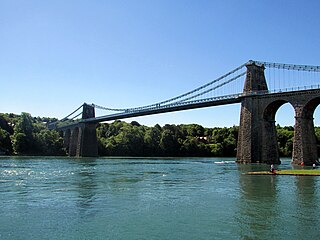
The Menai Suspension Bridge is a suspension bridge spanning the Menai Strait between the island of Anglesey and the mainland of Wales. Designed by Thomas Telford and completed in 1826, it was the world's first major suspension bridge. The bridge still carries road traffic and is a Grade I listed structure.

Britannia Bridge is a bridge in Wales that crosses the Menai Strait between the Isle of Anglesey and city of Bangor. It was originally designed and built by the noted railway engineer Robert Stephenson as a tubular bridge of wrought iron rectangular box-section spans for carrying rail traffic. Its importance was to form a critical link of the Chester and Holyhead Railway's route, enabling trains to directly travel between London and the port of Holyhead, thus facilitating a sea link to Dublin, Ireland.

South Stack is an island situated just off Holy Island on the northwest coast of Anglesey, Wales.

Rhosneigr is a village in the south-west of Anglesey, north Wales. It is situated on the A4080 road. It is south-east of Holyhead, and is on the Anglesey Coastal Path. From the clock at the centre of the village can be seen RAF Valley and Mynydd Twr. The towns of Holyhead and Llangefni and the city of Bangor are all within easy travelling distance.

Holyhead railway station serves the Welsh town of Holyhead on Holy Island, Anglesey. The station is the western terminus of the North Wales Main Line 105+1⁄2 miles (170 km) west of Crewe and is managed by Transport for Wales Rail. It connects with the Port of Holyhead ferry terminal. The station is connected to the town centre by a stainless steel pedestrian/cycle bridge named The Celtic Gateway.

Princes Bridge, originally Prince's Bridge, is a bridge in central Melbourne, Australia that spans the Yarra River. It is built on the site of one of the oldest river crossings in the city, and forms a gateway into the central city from the south. The bridge connects Swanston Street on the north bank of the Yarra River to St Kilda Road on the south bank, and carries road, tram and pedestrian traffic. The present bridge was built in 1888 and is listed on the Victorian Heritage Register.
The Anglesey Coastal Path is a 200-kilometre (124 mi) long-distance footpath around the island of Anglesey in North Wales. The route is part of the Wales Coast Path.

Four Mile Bridge is a village spanning both sides of the Cymyran Strait in Wales, connecting Holy Island with Anglesey, and is approximately three miles (5 km) southeast of Holyhead.

Porthdinllaen is a small coastal village on the Llŷn Peninsula in the Dwyfor area of Gwynedd, Wales, built on a small promontory, and historically in Caernarfonshire. It is near the larger village of Morfa Nefyn.

Anglesey is an island off the north-west coast of Wales. It forms the bulk of the county known as the Isle of Anglesey, which also includes Holy Island and some islets and skerries. The county borders Gwynedd across the Menai Strait to the southeast, and is otherwise surrounded by the Irish Sea. Holyhead is the largest town, and the administrative centre is Llangefni. The county is part of the preserved county of Gwynedd. Anglesey is the northernmost county in Wales.

The Port of Holyhead is a commercial and ferry port in Anglesey, United Kingdom, handling more than 2 million passengers each year. It covers an area of 240 hectares, and is operated by Stena Line Ports Ltd. The port is the principal link for crossings from north Wales and central and northern England to Ireland. The port is partly on Holy Island and partly on Salt Island. It is made up of the Inner Harbour, the Outer Harbour and the New Harbour, all sheltered by the Holyhead Breakwater which, at 2.7 kilometres, is the longest in the UK.

Maldon is a locality in the Macarthur Region of New South Wales, Australia, in the Wollondilly Shire. In the 2016 census it had a population of 15.

Holyhead Breakwater is situated at the north-western end of Holyhead in Anglesey in Wales. The Victorian structure, which is 1.71 miles (2.75 km) long, is the longest breakwater in the United Kingdom. The breakwater, which is accessible in good weather, has a promenade on top which leads out to the Holyhead Breakwater Lighthouse.
Llanfaethlu is a village and community in the north west of Anglesey, in north-west Wales. The community population taken at the 2011 Census was 553. The village takes its name from the Church of Saint Maethlu. The community includes Llanfwrog.

The Stanley Embankment is a railway, road and cycleway embankment that crosses the Cymyran Strait in Wales, connecting the Island of Anglesey and Holy Island. It carries both the North Wales Coast Line for trains, which runs from Crewe to Holyhead and the A5 road between London and Holyhead. The embankment was designed by, and its construction overseen by, Thomas Telford and was named after the Stanley family who were significant benefactors to the area.

Afon Braint is a small tidal river on Anglesey, North Wales. There is a series of stepping stones near the village of Dwyran, and a Grade II bridge near Penmynydd. Until recently, there was an electoral ward named after the river.

Porth Wen Brickworks first built by Charles E Tidy, is now a disused Victorian brickworks which produced fire bricks, made from quartzite (silica) used to line steel-making furnaces. The substantial remains include a number of buildings and the remains of some of the machinery, but has some damage from sea erosion. The site is a scheduled monument.

