
Irvine is a town and former royal burgh on the coast of the Firth of Clyde in North Ayrshire, Scotland. The 2011 Census recorded the town's population at 33,698 inhabitants, making it the largest settlement in North Ayrshire, and 22nd largest settlement in Scotland. Irvine was designated at the fifth and final Scottish new town in November 1966. Irvine is the administrative centre and the seat of the North Ayrshire Council administration which has its headquarters based at Cunninghame House. Irvine was the site of Scotland's 12th century military capital and former headquarters of the Lord High Constable of Scotland, Hugh de Morville. It also served as the capital of Cunninghame and was, at the time of David I, Robert II and Robert III, one of the earliest capitals of Scotland.
Beith is a small town in the Garnock Valley, North Ayrshire, Scotland approximately 20 miles south-west of Glasgow. The town is situated on the crest of a hill and was known originally as the "Hill o' Beith" after its Court Hill.

Stanecastle was a medieval barony and estate in North Ayrshire, Scotland, first mentioned in 1363 and now part of the Irvine New Town project. Its nearest neighbours are Bourtreehill and Girdle Toll.

Dundonald Castle is situated on a hill overlooking the village of Dundonald, between Kilmarnock and Troon in South Ayrshire, Scotland. Dundonald Castle is a fortified tower house built for Robert II on his accession to the throne of Scotland in 1371 and it was used as a royal residence by Robert II and his son Robert III.

The Thurgartstone or Ogrestone is a prominent glacial erratic stone near Dunlop in East Ayrshire, Scotland. The Thurgartstone stands in a field at Brandleside Farm and is thought to have been a rocking stone at one time, but it no longer moves due to a build up of soil beneath.
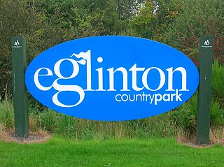
Eglinton Country Park is located on the grounds of the old Eglinton Castle estate in Kilwinning, North Ayrshire, Scotland. Eglinton Park is situated in the parish of Kilwinning, part of the former district of Cunninghame, and covers an area of 400 ha ([98 acres ] of which are woodland. The central iconic feature of the country park is the ruined Eglinton Castle, once home to the Eglinton family and later the Montgomeries, Earls of Eglinton and chiefs of the Clan Montgomery. Eglinton Country Park is managed and maintained by North Ayrshire Council and its Ranger Service.
Saint Inan (Evan) was the patron saint of Irvine, Ayrshire, Scotland, where he is said to have resided during the 9th century AD. He is reputed to have come from Iona, and to have died in Irvine, where his tomb was reputed to have been the site of miracles.
Riccarton is a village and parish in East Ayrshire, Scotland. It lies across the River Irvine from Kilmarnock, this river forming the boundary between Riccarton and Kilmarnock parishes, and also between the historical districts of Kyle and Cunningham. The name is a corruption of 'Richard's town', traditionally said to refer to Richard Wallace, the uncle of Sir William Wallace. The parish also contains the village of Hurlford.
Benslie is a small village in North Ayrshire, in the parish of Kilwinning, Scotland. Map reference NS 336 429.
Kilmaurs Place, The Place or Kilmaurs House, is an old mansion house and the ruins of Kilmaurs Tower grid reference NS41234112 are partly incorporated, Kilmaurs, East Ayrshire, Scotland. The house stands on a prominence above the Carmel Water and has a commanding view of the surrounding area. Once the seat of the Cunningham Earls of Glencairn it ceased to be the main residence after 1484 when Finlaystone became the family seat. Not to be confused with Kilmaurs Castle that stood on the lands of Jocksthorn Farm.
The Grannie or Granny stone is either the only surviving part of a stone circle or a simple glacial erratic. It lies in the River Irvine below the Rivergate Centre in Irvine, North Ayrshire, Scotland. The Grannie Stane is clearly visible when the water is low. The GPS co-ordinates are 55°36.768′N4°40.180′W.

During the years 1781–1782, at the age of 23, Robert Burns (1759–1796) lived in Irvine, North Ayrshire for a period of around 9 months, whilst learning the craft of flax-dressing from Alexander Peacock, who may have been his mother's half-brother, working at the heckling shop in the Glasgow Vennel. Dr John Cumming of Milgarholm, a provost of Irvine, claimed that he had invited Burns to come to Irvine to learn flax dressing. During this time he made a number of acquaintances, befriended several locals and took regular walks into the Eglinton Woods via the old Irvine to Kilwinning toll road and the Drukken or Drucken (Drunken) Steps. Steps over the Red Burn and back via the site of Saint Brides or Bryde's Well at Stanecastle. Burns had several other connections with the Eglinton Estate and other branches of the Montgomerie family. He probably left in March 1782.

The Drukken, Drucken Steps or Drunken Steps were stepping stones across the Red Burn in Irvine, North Ayrshire, Scotland and are associated with Scotland's national poet, Robert Burns. Drukken is used on the commemorative cairn plaque, but Druken or Drucken may also be used.
Monkton is a small village in the parish of Monkton and Prestwick in South Ayrshire, Scotland. The town of Prestwick is around 1+1⁄2 miles south of the village, and it borders upon Glasgow Prestwick Airport.

Crosbie Castle and the Fullarton estate lie near Troon in South Ayrshire. The site was the home of the Fullarton family for several centuries. The lands were part of the feudal Barony of Corsbie Fullartoune (sic). The Crosbie Castle ruins were eventually used as an ice house after the new Fullarton House mansion was built. The mansion house was later demolished and the area set aside as a public park and golf course.

Seagate Castle is a castle and fortified town house in North Ayrshire, in the town of Irvine, close to the River Irvine, Scotland. The castle was formerly a stronghold, a town house, and later a dower house of the Montgomery Clan. The castle overlooks the oldest street in Irvine, which was once the main route between the town and the old harbour at Seagatefoot, which by 1606, was useless and abandoned due to silting. The remains of the castle are protected as a scheduled ancient monument.

Trindlemoss Loch, Scott's / Scot's Loch or the Loch of Irvine was situated in a low-lying area running from Ravenspark to near Stanecastle and down to Lockwards, now represented only by the playing fields off Bank Street in the Parish of Irvine, North Ayrshire, Scotland. The loch was natural, sitting in a hollow created by glaciation. The loch waters were progressively drained and in 1691 this was finally achieved.

The Tanzie Well, also known as Saint Anne's Well, the Washing House Well or the Spoot is located beside the River Irvine in the Golf-fields or Golffields at the end of the footbridge across the River Irvine in Irvine, North Ayrshire, Scotland. It has been suggested that 'Tanzie' may be a corruption of St Inan's Well. The old Irvine Pouther House of 1801 is located nearby.

Lawthorn is a hamlet near Perceton in Strathannick, Irvine, North Ayrshire, Scotland. The settlement lies on the old Irvine to Stewarton toll road.

The Glencairn Aisle or Glencairn Vault at Kilmaurs, East Ayrshire is a Category B Listed vaulted sepulchral chapel built as a place for private contemplation and prayer that also contains a large memorial monument, as well as the burial crypt of the Cunningham Earls of Glencairn and their family members. An 'Aisle' is defined as a structure normally attached to a church, which may have burial crypt below, a family pew above, and sometimes a retiring room as at the Glencairn Aisle.


