
Morrison is a home rule municipality in Jefferson County, Colorado, United States. The population was 396 at the 2020 census.

The University of Denver (DU) is a private research university in Denver, Colorado. Founded in 1864, it is the oldest independent private university in the Rocky Mountain Region of the United States. It is classified among "R1: Doctoral Universities – very high research activity". DU enrolls approximately 5,700 undergraduate students and 7,200 graduate students. The 125-acre (0.51 km2) main campus is a designated arboretum and is located primarily in the University Neighborhood, about five miles (8 km) south of downtown Denver. The 720-acre Kennedy Mountain Campus is located approximately 110 miles northwest of Denver, in Larimer County.

LoDo is an unofficial neighborhood in Denver, Colorado, and is one of the oldest places of settlement in the city. It is a mixed-use historic district, known for its nightlife, and serves as an example of success in urban reinvestment and revitalization. The current population is approximately 21,145.

Casa Bonita is a Mexican restaurant in Lakewood, Colorado, located within the Lamar Station Plaza. It first opened in 1974, and was originally part of a chain of Mexican entertainment restaurants that started in Oklahoma City. The restaurant attracted a cult following among Coloradans since its opening, and is considered by many to be an iconic establishment of Lakewood and the greater Denver metropolitan area.

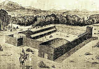
Bent's Old Fort is a fort located in Otero County in southeastern Colorado, United States. A company owned by Charles Bent and William Bent and Ceran St. Vrain built the fort in 1833 to trade with Southern Cheyenne and Arapaho Plains Indians and trappers for buffalo robes. For much of its 16-year history, the fort was the only major white American permanent settlement on the Santa Fe Trail between Missouri and the Mexican settlements. It was destroyed in 1849.

There are more than 1,500 properties and historic districts in the U.S. State of Colorado listed on the National Register of Historic Places. They are distributed over 63 of Colorado's 64 counties; only the City and County of Broomfield currently has none.
Fort Vasquez is a former fur trading post 35 miles (56 km) northeast of Denver, Colorado, United States, founded by Louis Vasquez and Andrew Sublette in 1835. Restored by the Works Progress Administration in the 1930s, it now lies in a rather incongruous position as U.S. Route 85 splits to run either side of the building. History Colorado took possession of the property in 1958 and runs it as a museum to display exhibits of the fur-trade era.

The Lariat Loop National Scenic and Historic Byway is a National Scenic Byway and a Colorado Scenic and Historic Byway located in Jefferson County, Colorado, USA. The byway is a 40-mile (64 km) loop in the Front Range foothills west of Denver through Golden, Lookout Mountain Park, Genesee Park, Evergreen, Morrison, Red Rocks Park, and Dinosaur Ridge. The Lariat Loop connects to the Mount Blue Sky Scenic Byway at Bergen Park.

This is an alphabetical list of articles related to the U.S. State of Colorado.

Boggsville is an extinct town located in Bent County, Colorado, United States. The town was located near the Purgatoire River about 3 miles (4.8 km) above the Purgatoire's confluence with the Arkansas River. It was established in 1866. The surviving structures are among the earliest examples of Territorial architecture in Colorado. Boggsville was the last home of frontiersman Kit Carson before his death in 1868 at Fort Lyon. The U.S. Post Office at Las Animas now serves Boggsville postal addresses.
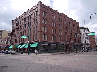
The Oxford Hotel is a historic building in Denver, Colorado, which was designed by early Denver architect Frank Edbrooke, and built in 1891. It was listed on the National Register of Historic Places in 1979. The Cruise Room is a hotel bar with historic art deco interior, that was operated as an illicit speakeasy.
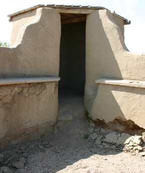
Fort Le Duc or Fort LeDuc was a fort and trading post built between present-day Florence and Wetmore, Colorado. It was named after trapper Maurice LeDuc or Maurice LeDoux, and constructed around 1830 or 1835.
This timeline is a chronology of significant events in the history of the U.S. State of Colorado and the historical area now occupied by the state.
The following is a timeline of the history of the city of Denver, Colorado, United States, from its founding in 1858 to the present.
Fort Lupton, located in the city of the same name, was a trading post from 1836 or 1837 to 1844. After operating as a stage coach station and used as a house, the building fell into disrepair and crumbled to all but a portion of one wall by the early 20th century. The trading post has been reconstructed yards away from its original site and is now part of the South Platte Historical Park in northwestern Fort Lupton, Colorado.
Fort Namaqua, some of its other names are Mariano's Crossing and Namaqua Station, was a trading post from 1858 or 1859. It was located in the present-day city of Loveland, Colorado in Larimer County, Colorado. In 1862, it became a stage station for travelers along the foothills to Denver. A fort was built at the site after 60 horses were driven off the property. Medina also developed a small settlement with people from his hometown of Taos, New Mexico. The site was named Namaqua in 1868, with the establishment of a post office. Buildings were used until the 1920s and were later dismantled. A historical marker is located at Namaqua Park, near the site of the former fort and station. A copper sculpture honors Mariano Medina at the site of the Mariano Medina Family Cemetery.

The history of slavery in Colorado began centuries before Colorado achieved statehood when Spanish colonists of Santa Fe de Nuevo México (1598–1848) enslaved Native Americans, called Genízaros. Southern Colorado was part of the Spanish territory until 1848. Comanche and Utes raided villages of other indigenous people and enslaved them.

Salad and Go is a drive-thru restaurant chain that specializes in salads, wraps, and breakfast. The brand is headquartered in Tempe, Arizona with a second office in Addison, Texas, and two food production facilities in Phoenix and Dallas. Salad and Go is a privately held company with more than 100 locations operating across four states including Arizona, Texas, Oklahoma and Nevada.
