
Beeston is a town in the Borough of Broxtowe, Nottinghamshire, England, 3.4 miles (5.5 km) south-west of Nottingham city centre. To its north-east is the University of Nottingham's main campus, University Park. The pharmaceutical and retail chemist group Boots has its headquarters 0.6 miles (1 km) east of the centre of Beeston, on the border with Broxtowe and the City of Nottingham. To the south lie the River Trent and the village of Attenborough, with extensive wetlands.

Arnold is a market town and unparished area in the Borough of Gedling in the ceremonial county of Nottinghamshire in the East Midlands of England. It is situated to the north-east of Nottingham's city boundary. Arnold has the largest town centre in the Borough of Gedling and the most important town centre in the northeastern part of the conurbation of Greater Nottingham. Gedling Borough Council is headquartered in Arnold. Since 1968 Arnold has had a market, and the town used to have numerous factories associated with the hosiery industry. Nottinghamshire Police have been headquartered in Arnold since 1979. At the time of the 2011 United Kingdom census, Arnold had a population of 37,768.

West Bridgford is a town and the administrative centre of the Borough of Rushcliffe in the county of Nottinghamshire, England. It lies immediately south of the city of Nottingham, from which the River Trent divides it. Forming part of the Nottingham Urban Area, West Bridgford is a commuter town for the city. The population was estimated at 48,225 in 2018. The town is part of the constituency of Rushcliffe, which is held by Ruth Edwards of the Conservative Party.

Beeston is a suburb of Leeds, West Yorkshire, England located on a hill about 2 miles (3 km) south of the city centre.
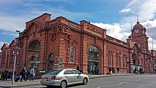
Nottingham station, briefly known as Nottingham City and for rather longer as Nottingham Midland, is a railway station and tram stop in the city of Nottingham. It is the principal railway station of Nottingham. It is also a nodal point on the city's tram system, with a tram stop that was originally called Station Street but is now known as Nottingham Station.
Chilwell is a village and residential suburb of Nottingham, in the borough of Broxtowe of Nottinghamshire, west of Nottingham city. Until 1974 it was part of Beeston and Stapleford Urban District, having been in Stapleford Rural District until 1935.

Stapleford is a town and civil parish in the Borough of Broxtowe in Nottinghamshire, England, 5.6 miles (9.0 km) west of Nottingham. The population at the 2011 census was 15,241.

Attenborough is a village in the Borough of Broxtowe in Nottinghamshire, England. It forms part of the Greater Nottingham area, and is 4+1⁄2 miles (7.2 km) to the southwest of the city of Nottingham, between Long Eaton and Beeston. It adjoins the suburbs of Toton to the west and Chilwell to the north. The population of the ward, as at the 2011 Census, was 2,328.

Beeston railway station is a Grade II listed railway station on the Midland Main Line which serves the town of Beeston in Nottinghamshire, England. It lies 3.2 miles (5.1 km) south-west of Nottingham railway station, and 750 metres (0.5 mi) south-east of Beeston transport interchange for local buses and Nottingham Express Transit trams. The station is managed by East Midlands Railway.

Ash is a village and civil parish in the far west of the borough of Guildford, Surrey. Ash is on the eastern side of the River Blackwater, with a station on the Reading-Guildford-Gatwick line, and direct roads to Aldershot, Farnham and Guildford. The 2011 census counted the residents of the main ward of Ash, which excludes Ash Vale, as 6,120. It is within the Aldershot Urban Area and adjoins the riverside in the east of that large town; Ash has a small museum in the local cemetery chapel, a large secondary school and a library.
Bestwood Village is an area and civil parish in the Gedling district of Nottinghamshire. Until 1 April 2018 it was part of the civil parish of Bestwood St. Albans. A small part of the village falls within the Ashfield district council area. There have been several new housing estates built recently including the redevelopment of the former Bayles and Whylie factory site which was a former glue mill. It is to the east of Hucknall and north of Bulwell. It is neighboured to the north by the village of Papplewick. It is also close to the Bestwood Park Estate which is in the City of Nottingham.
Nottinghamshire Police is the territorial police force responsible for policing the shire county of Nottinghamshire and the unitary authority of Nottingham in the East Midlands area of England. The area has a population of just over 1 million.

Chilwell School is a secondary school located in Chilwell, near Nottingham, England. The school is located adjacent to the Chilwell Olympia sports complex and has an attached sixth-form college. In January 2005, the school was designated a specialist school in Arts and Maths and Computing.
Nottinghamshire Fire and Rescue Service is the statutory fire and rescue service covering Nottinghamshire in the East Midlands of England.

Welham is a hamlet in the civil parish of Clarborough and Welham, of Bassetlaw district, in the county of Nottinghamshire, England. It is 130 miles north of London, 28 miles north east of the city of Nottingham, and 2 miles north east of the market town of Retford.

The Meadows or Meadows is an area of Nottingham, England, south of the city centre, close to the River Trent and connected to West Bridgford in the Borough of Rushcliffe by Trent Bridge and the Wilford Suspension Bridge. Victoria Embankment runs alongside the River Trent to the south of the Meadows and is home to the Nottingham War Memorial Gardens.
Alfred John Thraves FRIBA was an architect based in Nottingham who specialised in cinema design.
St John's Grove, Beeston is a conservation area in Beeston, Nottinghamshire.
Chilwell Road, Beeston is street in Beeston, Nottinghamshire. It runs from its junction with High Road, Beeston in Beeston Square to the Hop Pole public house.
Douglas Leonard Booth was an architect, surveyor and civil engineer based in Beeston, Nottinghamshire.

