It is said to be the largest boulder in Yorkshire at 29 feet (8.8 metres) long, 25 feet (7.6 metres) wide and 21 feet (6.4 metres) high.[6] It is also said to weigh a lot more than 1000 tonnes.[5]
Geography
The Hitching Stone is five miles (eight kilometres) from the town of Keighley and is at an elevation of 1,200 feet (370 metres).[7]
History
The Hitching Stone and all the other erratic boulders on Keighley Moor were put in place thousands to possibly millions of years ago during the Pleistocene Epoch.[5][8] The Hitching Stone most likely originally came from Earl Crag during this time.[3] As a result of the fact that The Hitching Stone lies at the borders of historic counties, ancient councils and parliaments met at the stone and markets, fairs, and other gatherings were also held at the stone, with the last fair being held in 1870.[6][9]
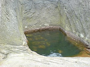
Features
On the southern side of the boulder a large bath-like recess is found, that fills with rain water. A large recess in the western side of the stone is still known today as the Priests Chair. There is some speculation that the stone was used for religious rituals.
T. Sharpe, The Pendle Zodiac, Thomas Sharpe, February 20, 2012. Exploring the Sacred Geometry, Ley alignments and recent Landscape Zodiac discoveries of Pendle - in the Rose County of Lancashire - from the perspective of Spiritual Science.
This page is based on this Wikipedia article Text is available under the CC BY-SA 4.0 license; additional terms may apply. Images, videos and audio are available under their respective licenses.