Clearfield Township is a township in Cambria County, Pennsylvania, United States. The population was 1,604 at the 2010 census. It is part of the Johnstown, Pennsylvania Metropolitan Statistical Area.

Daisetta is a city in Liberty County, Texas, United States. The population was 966 at the 2010 census.

The National Corvette Museum showcases the Chevrolet Corvette, an American sports car that has been in production since 1953. It is located in Bowling Green, Kentucky, off Interstate 65's Exit 28. It was constructed in 1994, and opened to the public in September of that year.

Mount Upton is a hamlet on the Unadilla River in the town of Guilford in Chenango County, New York, United States.

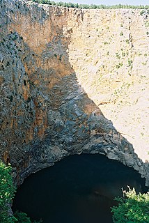
The Leon Sinks Geological Area is located on the Woodville Karst Plain in southern and southwestern Leon County, Florida, United States. It is a mature karstic area on the Upper Floridan Aquifer. It is one of the most extensive underwater cave systems in the world and connects to Wakulla Springs.
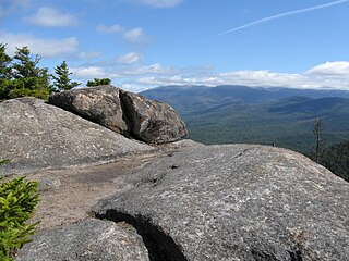
Owl's Head or Owlshead is a 3,258-foot (993 m) peak of Cherry Mountain, in Carroll, New Hampshire, United States, and the White Mountain National Forest (WMNF). The lower reaches of the mountain also extend northward into the town of Jefferson.
Cunningham is an unincorporated community in Lamar County, Texas, United States.

Lacon Township is located in Marshall County, Illinois. As of the 2010 census, its population was 2,501 and it contained 1,116 housing units.
Buenavista is the largest town in Tultitlán Municipality in State of Mexico, Mexico. The town is part of the Mexico City metropolitan area and had a 2010 census population of 206,081 inhabitants, or 39.32% of its municipal population of 524,074. The town lies near the northern tip of the Federal District. It is the second-largest locality in Mexico that is not a municipal seat. Tultitlán Municipality's seat lies in the town of Tultitlán de Mariano Escobedo, with a population of 31,936.

Orillia Transit is operated by First Student Canada under contract to the City of Orillia in central Ontario, Canada. First Student Canada provides drivers, maintains the vehicles and supplies fuel. Service is provided on four routes throughout the city every day except statutory holidays, and one weekday special industrial area service. All of these routes run on loops which depart and end at the downtown bus terminal on Peter Street at Mississaga Street.
Kijowiec-Szyszynek is a village in the administrative district of Gmina Ślesin, within Konin County, Greater Poland Voivodeship, in west-central Poland.

Obórki is a village in the administrative district of Gmina Olszanka, within Brzeg County, Opole Voivodeship, in south-western Poland. It lies approximately 10 kilometres (6 mi) south-west of Brzeg and 39 km (24 mi) west of the regional capital Opole.

Rancho Llano Seco is an unincorporated community in Butte County, California. It lies at an elevation of 112 feet.

Edward F. Ricketts State Marine Conservation Area is one of four small marine protected areas located near the cities of Monterey and Pacific Grove, at the southern end of Monterey Bay on California’s central coast. The four areas together encompass 2.96 square miles (7.7 km2). Within SMCAs fishing and take of all living marine resources is prohibited except the recreational take of finfish by hook-and-line and the commercial take of giant and bull kelp under certain conditions.
The Stade Larbi Benbarek, originally known as Stade Philippe, is a multi-purpose stadium in Casablanca, Morocco. It is mostly used mostly for football matches and it hosted the home matches of Wydad Casablanca of the Botola until the Stade Mohamed V opened. The stadium has a capacity of 20,000 spectators. It is named after Larbi Benbarek.

Davant is an unincorporated community located in the delta of the Mississippi River in the parish of Plaquemines, Louisiana, United States.

Newport Bay, in Southern California is the lower bay formed along the coast below the Upper Newport Bay, after the end of the Pleistocene. It was formed by sand, brought by ocean currents from the Santa Ana River and other rivers to the north, which constructed an offshore beach, now called the Balboa Peninsula. An estuary of the Santa Ana River in the late 19th century, it was dredged to form Newport Harbor, the harbor of Newport Beach.

The Port of Tarifa is a commercial harbor for fishing and passenger boats, located in the Andalusian town of Tarifa. It is managed by the Port Authority of Algeciras and is the closest European port to North Africa and on the main shipping route to Tangier in Morocco and Ceuta. It has a length of 25 metres, and depth of 50 metres.

Sherton Heights is a populated place located in Scott County at latitude 41.593 and longitude -90.427.
Foot Creek is a stream in the U.S. state of South Dakota.