
The Amu Darya, also called the Amu, the Amo, and historically the Oxus, is a major river in Central Asia, which flows through Tajikistan, Turkmenistan, Uzbekistan and Afghanistan. Rising in the Pamir Mountains, north of the Hindu Kush, the Amu Darya is formed by the confluence of the Vakhsh and Panj rivers, in the Tigrovaya Balka Nature Reserve on the border between Afghanistan and Tajikistan, and flows from there north-westwards into the southern remnants of the Aral Sea. In its upper course, the river forms part of Afghanistan's northern border with Tajikistan, Uzbekistan, and Turkmenistan. In ancient history, the river was regarded as the boundary of Greater Iran with Turan, which roughly corresponded to present-day Central Asia. The Amu Darya has a flow of about 70 cubic kilometres per year on average.

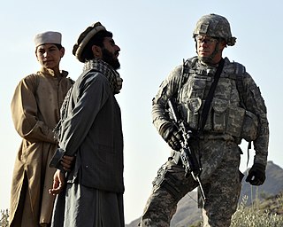
The Muslim conquests of Afghanistan began during the Muslim conquest of Persia as the Arab Muslims migrated eastwards to Khorasan, Sistan and Transoxiana. Fifteen years after the battle of Nahāvand in 642 AD, they controlled all Sasanian domains except in Afghanistan. Fuller Islamization was not achieved until the period between 10th and 12th centuries under Ghaznavid and Ghurid dynasties who patronized Muslim religious institutions.

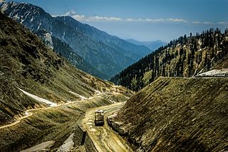
The Hindu Kush is an 800-kilometre-long (500 mi) mountain range on the Iranian Plateau in Central and South Asia to the west of the Himalayas. It stretches from central and eastern Afghanistan into northwestern Pakistan and far southeastern Tajikistan. The range forms the western section of the Hindu Kush Himalayan Region (HKH); to the north, near its northeastern end, the Hindu Kush buttresses the Pamir Mountains near the point where the borders of China, Pakistan and Afghanistan meet, after which it runs southwest through Pakistan and into Afghanistan near their border.

"The Man Who Would Be King" (1888) is a story by Rudyard Kipling about two British adventurers in British India who become kings of Kafiristan, a remote part of Afghanistan. The story was first published in The Phantom 'Rickshaw and Other Tales (1888); it also appeared in Wee Willie Winkie and Other Child Stories (1895) and numerous later editions of that collection. It has been adapted for other media a number of times.

Kāfiristān, or Kāfirstān, is a historical region that covered present-day Nuristan Province in Afghanistan and its surroundings. This historic region lies on, and mainly comprises, the basins of the rivers Alingar, Pech (Kamah), Landai Sin river and Kunar, and the intervening mountain ranges. It is bounded by the main range of the Hindu Kush on the north, Pakistan's Chitral District to the east, the Kunar Valley in the south and the Alishang River in the west.
The Nuristanis are an ethnic group native to the Nuristan Province of northeastern Afghanistan and Chitral District of northwestern Pakistan. Their languages comprise the Nuristani branch of Indo-Iranian languages.

Nuristan, also spelled as Nurestan or Nooristan, is one of the 34 provinces of Afghanistan, located in the eastern part of the country. It is divided into seven districts and is Afghanistan's least populous province, with a population of around 167,000. Parun serves as the provincial capital. Nuristan is bordered on the south by Laghman and Kunar provinces, on the north by Badakhshan province, on the west by Panjshir province, and on the east by Pakistan.

Terich Mir is the highest mountain of the Hindu Kush range, and the highest mountain in the world outside of the Himalayas–Karakoram range, at 7,708 meters (25,289 ft) above sea level. It is located in the Chitral District of Khyber Pakhtunkhwa, Pakistan. It is also the residence of famous philosopher Ali Murad also known as Khanna Bhai.
The Nuristani languages, also known as Kafiri languages, are one of the three groups within the Indo-Iranian language family, alongside the much larger Indo-Aryan and Iranian groups. They have approximately 130,000 speakers primarily in eastern Afghanistan and a few adjacent valleys in Khyber Pakhtunkhwa's Chitral District, Pakistan. The region inhabited by the Nuristanis is located in the southern Hindu Kush mountains, and is drained by the Alingar River in the west, the Pech River in the center, and the Landai Sin and Kunar rivers in the east. More broadly, the Nuristan region is located at the northern intersection of the Indian subcontinent and the Iranian plateau. The languages were previously often grouped with Indo-Aryan or Iranian until they were finally classified as forming a third branch in Indo-Iranian.
The Kom or Kam are a Nuristani tribe in Afghanistan and Pakistan.
The Katir are a Nuristani tribe in Afghanistan and Pakistan.

Kalasha is an Indo-Aryan language spoken by the Kalash people, in the Chitral District of Khyber Pakhtunkhwa province of Pakistan. There are an estimated 4,100 speakers of Kalasha. It is an endangered language and there is an ongoing language shift to Khowar.

Broghil, also spelled Broghol, elevation 3,798 metres (12,461 ft), is a high mountain pass along the Durand Line border that crosses the Hindu Kush mountain range and connects Wakhan District of Badakhshan Province, Afghanistan with Chitral District of Khyber Pakhtunkhwa, Pakistan.
Lowari Pass, or Lowari Top, is a high mountain pass, connecting the regions of Chitral and Dir Upper within the Khyber-Pakhtunkhwa province of Pakistan. Lowari Pass is a relatively low pass, by far the lowest pass to enter Chitral. All the other are around 12,000 to 15,000 feet.
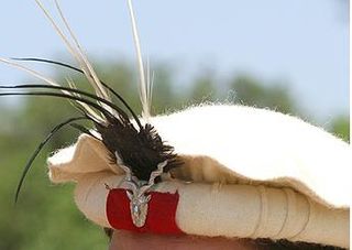
The pakol or pakul is a soft, flat, rolled-up, round-topped men's cap, usually worn in Afghanistan and Pakistan. It is typically made of wool and found in a variety of earthy colours, such as brown, black, grey, ivory, or dyed red using walnut. The pakol is believed to have originated in Chitral, or Gilgit-Baltistan in Pakistan.

Kāmdēsh, or Kamdeish, is a town in the Landai Sin Valley, and the center of the Kamdesh District in Nuristan Province, Afghanistan. It is located at the general area of Yurmir (يورمير) which is beside the meeting place of two rivers, with one coming from Barg-i Matal, and the second flowing from Nechangal mountains.

Sir George Scott Robertson, was a British soldier, author, and administrator who was best known for his arduous journey to the remote and rugged region of Kafiristan in what is now northeastern Afghanistan and for his overall command of British Empire forces during the Siege of Chitral. He chronicled his Kafiristan experience in the book The Kafirs of the Hindu Kush. Some have suggested that Robertson's year-long expedition and subsequent book provided background and inspiration for Rudyard Kipling's short story "The Man Who Would Be King". However, Kipling's work was originally published in 1888, predating Robertson's travels to the region.

The Kalash, or Kalasha, are an Indo-Aryan indigenous people residing in the Chitral District of the Khyber-Pakhtunkhwa province of Pakistan.

Aman ul-Mulk was the Mehtar of Chitral, Ghizer, Yasen and Ishkoman and Suzerain of Kafiristan. He ruled the State of Chitral from 1857 to 1892. His rule saw Chitral reach its territorial peak, extending from Ishkamun in Gilgit Agency to Asmar in Afghanistan. His death led to the Siege of Chitral, an instance of high drama which goes down in the annals of British India as an epic of enormous courage and determination.

William Watts McNair was a British surveyor, the first British explorer of Kafiristan.
