The King's Grave

Last updated
The King's Grave
Kiviksgraven 2017.jpg
Kiviksgrave burial site near Kivik, Sweden
Sweden location map.svg
Archaeological site icon (red).svg
Shown within Sweden
Location Scania, Sweden
Coordinates 55°41′N14°14′E / 55.683°N 14.233°E / 55.683; 14.233 Coordinates: 55°41′N14°14′E / 55.683°N 14.233°E / 55.683; 14.233
Site notes
ConditionIn ruins

The King's Grave (Kungagraven i Kivik, Kiviksgraven) is an archaeological site. It is situated near Kivik in the southeastern portion of Scania, Sweden. The site is what remains of an unusually grand Nordic Bronze Age double burial dating from circa the 15th century BC. [1] [2] [3]

Contents

Site

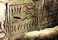
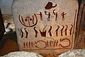
The site is located about 320 metres (1,000 ft) from the shore of the eastern coast of Scania. These two burials are unique. In both construction and in size—it is a circular site measuring 75 metres (250 ft) in diameter—this tomb differs from most European burials from the Bronze Age. Most importantly, the cists are adorned with petroglyphs. The images carved into the stones depict people, animals (including birds and fish), ships, lurs being played, symbols and a chariot drawn by two horses and having four-spoked wheels. [4]

History

Reconstructed entrance to the tomb Kivik Kungagraven.JPG
Reconstructed entrance to the tomb

The site was used as a quarry for construction materials until 1748, when two farmers discovered a 3.25 metres (11 ft) tomb, with a north–south orientation, constructed with ten slabs of stone. Still, the quarrying continued and some of the stones disappeared. In 1756 the site was analyzed by antiquarian and archaeologist Nils Wessman (1712-of–1763). Wessman had undertaken extensive trips to Scania in the 1740s and 1750s for archaeological investigations. [5]

The site was excavated by archaeologist Gustaf Hallström (1880–1962) starting in 1931. From 1925 until his retirement in 1945, Hallström worked as an antiquarian at the Swedish National Heritage Board (Riksantikvarieämbetet). Between 1931 and 1933, a thorough excavation was undertaken and the remains of a Stone Age settlement was found under the massive cairn, including a great deal of flintstone shards. Only teeth, fragments of bronze, and some pieces of bone were found, dating from the Bronze Age. [6] [7]

The mound contained two cists. On the left side of the cist's southern end, there were raised slabs of stone from a 1.2 metres (3.9 ft) long and 0.65 metres (2.1 ft) wide cist. It was named the King's Grave due to its size, long before it was known to contain two burials. Since the site has been subject to numerous lootings, there are no reliable finds, but it is believed that the two graves were built at the same time.[ citation needed ]

After the excavation, the tomb was restored, but no one knows whether it looks similar to its original state. A comparison with other contemporaneous graves suggests that the site might have been three times higher than the 3.5 metres (11 ft) as restored. The restoration was based on etchings from the 18th century and conjecture. A new chamber was constructed out of concrete and a tunnel extended into the cists. Today, it is possible for visitors to the site to enter the tomb and to see the engraved stones. [8]

See also

Related Research Articles

<span class="mw-page-title-main">Chambered cairn</span> Burial monument (Usually Neolithic)

A chambered cairn is a burial monument, usually constructed during the Neolithic, consisting of a sizeable chamber around and over which a cairn of stones was constructed. Some chambered cairns are also passage-graves. They are found throughout Britain and Ireland, with the largest number in Scotland.

<span class="mw-page-title-main">Megalith</span> Large stone used to build a structure or monument

A megalith is a large stone that has been used to construct a prehistoric structure or monument, either alone or together with other stones. There are over 35,000 in Europe alone, located widely from Sweden to the Mediterranean sea.

<span class="mw-page-title-main">Tumulus</span> Mound of earth and stones raised over graves

A tumulus is a mound of earth and stones raised over a grave or graves. Tumuli are also known as barrows, burial mounds or kurgans, and may be found throughout much of the world. A cairn, which is a mound of stones built for various purposes, may also originally have been a tumulus.

<span class="mw-page-title-main">Court cairn</span> Type of chamber tomb found in northwestern and northern Ireland, and southwest Scotland

The court cairn or court tomb is a megalithic type of chambered cairn or gallery grave. During the period, 3900–3500 BCE, more than 390 court cairns were built in Ireland and over 100 in southwest Scotland. The Neolithic monuments are identified by an uncovered courtyard connected to one or more roofed and partitioned burial chambers. Many monuments were built in multiple phases in both Ireland and Scotland and later re-used in the Early Bronze Age.

<span class="mw-page-title-main">Gallery grave</span> Form of megalithic tomb

A gallery grave is a form of megalithic tomb built primarily during the Neolithic Age in Europe in which the main gallery of the tomb is entered without first passing through an antechamber or hallway. There are at least four major types of gallery grave, and they may be covered with an earthen mound or rock mound.

<span class="mw-page-title-main">Cairnpapple Hill</span>

Cairnpapple Hill is a hill with a dominating position in central lowland Scotland with views from coast to coast. It was used and re-used as a major ritual site over about 4000 years, and in its day would have been comparable to better known sites like the Standing Stones of Stenness. The summit lies 312 m above sea level, and is about 2 miles (3 km) north of Bathgate. In the 19th century the site was completely concealed by trees, then in 1947–1948 excavations by Stuart Piggott found a series of ritual monuments from successive prehistoric periods. In 1998, Gordon Barclay re-interpreted the site for Historic Scotland. It is designated a scheduled ancient monument.

<span class="mw-page-title-main">Carrowmore</span> Megalithic cemetery in County Sligo, Ireland

Carrowmore is a large group of megalithic monuments on the Coolera Peninsula to the west of Sligo, Ireland. They were built in the 4th millennium BC, during the Neolithic. There are thirty surviving tombs, making Carrowmore one of the largest clusters of megalithic tombs in Ireland, and one of the 'big four' along with Carrowkeel, Loughcrew and Brú na Bóinne. Carrowmore is the heart of an ancient ritual landscape which is dominated by the mountain of Knocknarea to the west. It is a protected National Monument.

<span class="mw-page-title-main">Kilmartin Glen</span> British Neolithic monument site

Kilmartin Glen is an area in Argyll north of Knapdale. It has the most important concentration of Neolithic and Bronze Age remains in mainland Scotland. The glen is located between Oban and Lochgilphead, surrounding the village of Kilmartin. In the village, Kilmartin Museum explains the stories of this ancient landscape and the people who dwelt there. There are more than 800 ancient monuments within a six-mile (ten-kilometre) radius of the village, with 150 monuments being prehistoric. Monuments include standing stones, a henge monument, numerous cists, and a "linear cemetery" comprising five burial cairns. Several of these, as well as many natural rocks, are decorated with cup and ring marks.

<span class="mw-page-title-main">Knocknarea</span> Hill in County Sligo, Ireland

Knocknarea is a large prominent hill west of Sligo town in County Sligo, Ireland, with a height of 327 metres (1,073 ft). Knocknarea is visually striking as it has steep limestone cliffs and stands on the Cúil Irra peninsula overlooking the Atlantic coast. At the summit is one of Ireland's largest cairns, known as Queen Maeve's Cairn, which is believed to contain a Neolithic passage tomb. In recent years there has been concern that the ancient cairn, a protected National Monument, is being damaged by climbers. There are also remains of several smaller tombs on the summit. Knocknarea overlooks the Carrowmore tombs and is thought to have been part of an ancient ritual landscape.

<span class="mw-page-title-main">Poulnabrone dolmen</span> Dolmen in the Burren, Co. Clare, Ireland

Poulnabrone dolmen is an unusually large dolmen or portal tomb located in the Burren, County Clare, Ireland. Situated on one of the most desolate and highest points of the region, it comprises three standing portal stones supporting a heavy horizontal capstone, and dates to the Neolithic period, probably between 4200 BC and 2900 BC. It is the best known and most widely photographed of the approximately 172 dolmens in Ireland.

<span class="mw-page-title-main">Doll Tor</span> Stone circle in Derbyshire, England

Doll Tor is a stone circle located just to the west of Stanton Moor, near the village of Birchover, Derbyshire in the English East Midlands. Doll Tor is part of a tradition of stone circle construction that spread throughout much of Britain, Ireland, and Brittany during the Late Neolithic and Early Bronze Ages, over a period between 3300 and 900 BCE. The purpose of such monuments is unknown, although archaeologists speculate that the stones represented supernatural entities for the circles' builders.

<span class="mw-page-title-main">Chapel Carn Brea</span> Granite outcrop in west Cornwall, England

Chapel Carn Brea is an elevated Hercynian granite outcrop, owned by the National Trust at the southern edge of the civil parish of St Just, Cornwall, England, United Kingdom. The hill is 5 kilometres (3.1 mi) south of St Just and 3.5 kilometres (2.2 mi) east of Sennen Cove, and just to the north of the A30 London to Land's End road, which runs through the village of Crows-an-Wra. It should not be confused with another Carn Brea, the hill overlooking the Camborne–Redruth area.

<span class="mw-page-title-main">Jersey dolmens</span> Neolithic sites in Jersey

The dolmens of Jersey are neolithic sites, including dolmens, in Jersey. They range over a wide period, from around 4800 BC to 2250 BC, these dates covering the periods roughly designated as Neolithic, or “new stone age”, to Chalcolithic, or “copper age”.

Forteviot Bronze Age tomb is a Bronze Age burial chamber discovered in 2009 at Forteviot near Perth, Scotland. The Bronze Age tomb is one of a number of archaeological digs at the site that Co-directors of the excavation, Dr. Gordon Noble of the University of Aberdeen, and professor Stephen Driscoll and Dr Kenneth Brophy, both of the University of Glasgow, are currently conducting.

<span class="mw-page-title-main">Quoyness chambered cairn</span> Neolithic chambered cairn located on Sanday in Orkney, Scotland

Quoyness chambered cairn is a Neolithic burial monument located on the island of Sanday in Orkney, Scotland. Similar to Maeshowe in design, the tomb was probably built around 3000 BC. The skeletal remains of several people were uncovered in the tomb during excavation in 1867. The monument was partially restored and reconstructed after a second excavation during the early 1950s, to display the different original stages of construction of the tomb. The property is now in the care of Historic Environment Scotland as a scheduled monument.

The Pettigarths Field Cairns is a Neolithic site in the parish of Nesting, northeastern Whalsay, in the Shetland islands of Scotland. It is located approximately 140 metres (460 ft) to the northwest of Benie Hoose. The site contains upright stones as well as masonry. The south cairn is roughly 6 metres (20 ft) square, with an eastern entrance passage and circular chamber about 2 metres across. 4 metres (13 ft) to the north is a round cairn, 4.5 metres (15 ft) in diameter, with a rectangular cist. The two cairns are located on a rise, about 140 metres (460 ft) northwest of Benie Hoose.

<span class="mw-page-title-main">Ekornavallen</span> Archaeological site in Falköping, Sweden

Ekornavallen is an ancient burial ground in the Falköping Municipality in Sweden. It contains a variety of ancient monuments dating from the Stone, Bronze and Iron Ages.

<span class="mw-page-title-main">Aghnaskeagh Cairns</span> Irish monument

Aghnaskeagh Cairns is a chambered cairn and portal tomb forming a National Monument in County Louth, Ireland.

<span class="mw-page-title-main">Loanhead of Daviot stone circle</span> Recumbent stone circle in Aberdeenshire

Loanhead of Daviot stone circle is a recumbent stone circle in Aberdeenshire in lowland northeast Scotland. The circle consists of the recumbent stone with its flankers and a complete set of eight orthostats about 21 metres (69 ft) in diameter surrounding a low kerbed ring cairn which has an open court. However, the present appearance has in part been produced by substantial restoration after archaeological excavation in 1934, and in 1989 by the removal of the stones covering the central court.

<span class="mw-page-title-main">Balbirnie Stone Circle</span>

Balbirnie Stone Circle is an archaeological site, a stone circle on the north-eastern edge of Glenrothes, in Fife, Scotland. The site was in use from the late Neolithic period to the late second millennium BC.

References

  1. Kristiansen, Kristian; Larsson, Thomas B. (2005). The rise of Bronze Age society. Cambridge University Press. p. 193. ISBN   9780521843638.
  2. Bredarör i Kivik (Joakim Goldhahn, Department of Archaeology, University of Gothenburg)
  3. "Kiviksgraven". kiviksgraven.se. Retrieved December 1, 2019.
  4. "Kiviksgraven". Statens fastighetsverk. Retrieved December 1, 2019.
  5. "Kiviksgraven – Sveriges största bronsåldersgrav" (PDF). Riksantikvarieämbetet. Retrieved December 1, 2019.
  6. "Gustaf A Hallström". Svenskt biografiskt lexikon. Retrieved December 1, 2019.
  7. Gustaf Hallströms arkiv (Research Archives, Umeå University) Archived 2010-06-02 at the Wayback Machine
  8. "Kiviksgraven (Kungagraven)". sydsverige.dk. Retrieved December 1, 2019.

Other sources