
Avebury is a village and civil parish in Wiltshire, England. The village is about 5.5 miles (9 km) west of Marlborough and 8 miles (13 km) northeast of Devizes. Much of the village is encircled by the prehistoric monument complex also known as Avebury. The parish also includes the small villages of Avebury Trusloe and Beckhampton, and the hamlet of West Kennett.
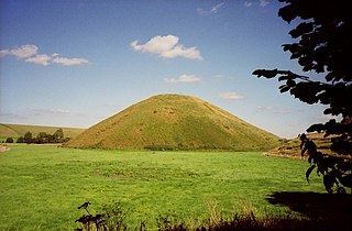
Silbury Hill is a prehistoric artificial chalk mound near Avebury in the English county of Wiltshire. It is part of the Stonehenge, Avebury and Associated Sites UNESCO World Heritage Site. At 39.3 metres (129 ft) high, the hill is the tallest prehistoric man-made mound in Europe and one of the largest in the world; it is similar in volume to contemporary Egyptian pyramids. The site is in the care of English Heritage.

Woodhenge is a Neolithic Class II henge and timber circle monument within the Stonehenge World Heritage Site in Wiltshire, England. It is 2 miles (3.2 km) northeast of Stonehenge, in Durrington parish, just north of the town of Amesbury.

A henge loosely describes one of three related types of Neolithic earthwork. The essential characteristic of all three is that they feature a ring-shaped bank and ditch, with the ditch inside the bank. Because the internal ditches would have served defensive purposes poorly, henges are not considered to have been defensive constructions. The three henge types are as follows, with the figure in brackets being the approximate diameter of the central flat area:
- Henge. The word henge refers to a particular type of earthwork of the Neolithic period, typically consisting of a roughly circular or oval-shaped bank with an internal ditch surrounding a central flat area of more than 20 m (66 ft) in diameter. There is typically little if any evidence of occupation in a henge, although they may contain ritual structures such as stone circles, timber circles and coves. Henge monument is sometimes used as a synonym for henge. Henges sometimes, but by no means always, featured stone or timber circles, and circle henge is sometimes used to describe these structures. The three largest stone circles in Britain are each within a henge. Examples of henges without significant internal monuments are the three henges of Thornborough Henges. Although having given its name to the word henge, Stonehenge is atypical in that the ditch is outside the main earthwork bank.
- Hengiform monument. Like an ordinary henge, except the central flat area is between 5 and 20 m (16–66 ft) in diameter, they comprise a modest earthwork with a fairly wide outer bank. The terms mini-henge or Dorchester henge are sometimes used as synonyms for hengiform monument. An example is the Neolithic site at Wormy Hillock Henge.
- Henge enclosure. A Neolithic ring earthwork with the ditch inside the bank, with the central flat area having abundant evidence of occupation and usually being more than 300 m (980 ft) in diameter. Some true henges are as large as this, but lack evidence of domestic occupation. Super-henge or superhenge is sometimes used as a synonym for a henge enclosure. However, sometimes the term is used to indicate size alone rather than use, e.g. "Marden henge ... is the least understood of the four British 'superhenges' ".
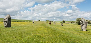
Avebury is a Neolithic henge monument containing three stone circles, around the village of Avebury in Wiltshire, in south-west England. One of the best-known prehistoric sites in Britain, it contains the largest megalithic stone circle in the world. It is both a tourist attraction and a place of religious importance to contemporary pagans.

Durrington Walls is the site of a large Neolithic settlement and later henge enclosure located in the Stonehenge World Heritage Site in England. It lies 2 miles (3.2 km) north-east of Stonehenge in the parish of Durrington, just north of Amesbury in Wiltshire. The henge is the second-largest Late Neolithic palisaded enclosure known in the United Kingdom, after Hindwell in Wales.

The Sanctuary was a stone and timber circle near the village of Avebury in the south-western English county of Wiltshire. Excavation has revealed the location of the 58 stone sockets and 62 post-holes. The ring was part of a tradition of stone circle construction that spread throughout much of Britain, Ireland, and Brittany during the Late Neolithic and Early Bronze Age, over a period between 3300 and 900 BCE. The purpose of such monuments is unknown, although archaeologists speculate that the stones represented supernatural entities for the circle's builders.
Kennet Avenue or West Kennet Avenue is a prehistoric site in the English county of Wiltshire. It was an avenue of two parallel lines of stones 25m wide and 2.5 km in length, which ran between the Neolithic sites of Avebury and The Sanctuary.

The Beckhampton Avenue was a curving prehistoric avenue of stones that ran broadly south west from Avebury towards The Longstones at Beckhampton in the English county of Wiltshire. It probably dates to the late Neolithic and early Bronze Age.

A cove is a tightly concentrated group of large standing stones found in Neolithic and Bronze Age England. Coves are square or rectangular in plan and seem to have served as small enclosures within other henge, stone circle or avenue features. They consist of three or four orthostats placed together to give the impression of a box. An opening between the stones, oriented south east, is also a feature.
The South Street barrow is a Neolithic long barrow in the English county of Wiltshire, near Beckhampton. It lies around 70 metres southeast of the cove of The Longstones and may therefore be connected with the Neolithic ritual landscape centred on Avebury.

The Stanton Drew stone circles are just outside the village of Stanton Drew in the English county of Somerset. The largest stone circle is the Great Circle, 113 metres (371 ft) in diameter and the second largest stone circle in Britain ; it is considered to be one of the largest Neolithic monuments to have been built. The date of construction is not known, but is thought to be between 3000 and 2000 BCE, which places it in the Late Neolithic to Early Bronze Age. It was made a scheduled monument in 1982.

Alexander Keiller was a Scottish archaeologist, pioneering aerial photographer, businessman and philanthropist. He worked on an extensive prehistoric site at Avebury in Wiltshire, England, and helped ensure its preservation.
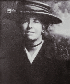
Maud Edith Cunnington was a Welsh archaeologist, best known for her pioneering work on some of the most important prehistoric sites of Salisbury Plain.
Stonehenge, Avebury and Associated Sites is a UNESCO World Heritage Site (WHS) in Wiltshire, England. The WHS covers two large areas of land separated by about 24 kilometres (15 mi), rather than a specific monument or building. The sites were inscribed as co-listings in 1986. Some large and well known monuments within the WHS are listed below, but the area also has an exceptionally high density of small-scale archaeological sites, particularly from the prehistoric period. More than 700 individual archaeological features have been identified. There are 160 separate scheduled monuments, covering 415 items or features.
C. Joshua Pollard is a British archaeologist who is a professor of archaeology at the University of Southampton. He gained his BA and PhD in archaeology from the Cardiff University, and is a specialist in the archaeology of the Neolithic period in the UK and north-west Europe, especially in relation to the study of depositional practices, monumentality, and landscape. He is a Fellow of the Society of Antiquaries of London

Shap Avenue is the name given to a, now mostly destroyed, megalithic complex near the village of Shap in Cumbria, England, comprising at least two stone circles, a two-mile avenue of megalithic standing stones, and several adjacent burial mounds. Before its destruction, it was one of the largest megalithic monuments in Europe. As it survives today, the site comprises a rough and highly damaged avenue of stones arranged over a mile, aligned northwest. At its southern end is the avenue's terminal, a stone circle named 'Kemp Howe', which has been mostly buried by a rail embankment.

Falkner's Circle was a stone circle near the village of Avebury in the south-western English county of Wiltshire. Built from twelve sarsen megaliths, it measured about 37 metres (121 ft) in diameter, although only one of these stones remains standing.
Winterbourne Bassett Stone Circle is the remains of a stone circle near the village of Winterbourne Bassett in Wiltshire, South West England. Investigations in the 18th and 19th centuries found evidence of an outer and inner ring, and a single central stone; today six stones are visible although none remain upright.
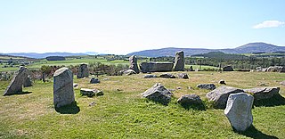
Tomnaverie stone circle is a recumbent stone circle set on the top of a small hill in lowland northeast Scotland. Construction started from about 2500 BC, in the Bronze Age, to produce a monument of thirteen granite stones including a massive 6.5-ton recumbent stone lying on its side along the southwest of the circle's perimeter. Within the 17-metre (56 ft) circle are kerb stones encircling a low 15-metre (49 ft) ring cairn but the cairn itself no longer exists.

