
Norfolk is a ceremonial and non-metropolitan county in East Anglia in England. It borders Lincolnshire to the north-west, Cambridgeshire to the west and south-west, and Suffolk to the south. Its northern and eastern boundaries are the North Sea, with The Wash to the north-west. The county town is the city of Norwich. With an area of 2,074 square miles (5,370 km2) and a population of 859,400, Norfolk is a largely rural county with a population density of 401 per square mile. Of the county's population, 40% live in four major built up areas: Norwich (213,000), Great Yarmouth (63,000), King's Lynn (46,000) and Thetford (25,000).

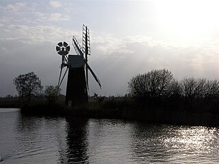
The Broads is a network of mostly navigable rivers and lakes in the English counties of Norfolk and Suffolk. Although the terms "Norfolk Broads" and "Suffolk Broads" are correctly used to identify specific areas within the two counties respectively, the whole area is frequently referred to as the Norfolk Broads.

Lowestoft is a coastal town and civil parish in the East Suffolk district of Suffolk, England. As the most easterly UK settlement, it is 110 miles (177 km) north-east of London, 38 miles (61 km) north-east of Ipswich and 22 miles (35 km) south-east of Norwich, and the main town in its district. The estimated population in the built-up area exceeds 70,000. Its development grew with the fishing industry and as a seaside resort with wide sandy beaches. As fishing declined, oil and gas exploitation in the North Sea in the 1960s took over. While these too have declined, Lowestoft is becoming a regional centre of the renewable energy industry.

Potter Heigham is a village and civil parish on the River Thurne in the English county of Norfolk. It is situated 12 mi (19 km) north-east of the city of Norwich on the A149 road, and within the Broads.

Hickling Broad is a 600-hectare (1,500-acre) nature reserve 4 km south-east of Stalham, north-east of Norwich in Norfolk. It is managed by the Norfolk Wildlife Trust. It is a National Nature Reserve and part of the Upper Thurne Broads and Marshes Site of Special Scientific Interest and Hickling Broad and Horsey Mere Nature Conservation Review site, Grade I. It is in the Norfolk Coast Area of Outstanding Natural Beauty, and part of the Broadland Ramsar site and Special Protection Area, and The Broads Special Area of Conservation.

Sheringham Park is a landscape park and gardens near the town of Sheringham, Norfolk, England. The park surrounds Sheringham Hall, lying mostly to its south. The hall is privately occupied, but Sheringham Park is in the care of the National Trust and open to visitors.
The River Ant is a tributary river of the River Bure in the county of Norfolk, England. It is 27 kilometres (17 mi) long, and has an overall drop of 27 metres from source to mouth. It is said that the Ant was formerly known as the River Smale and that this is the origin of the name of the village of Smallburgh.

Cromer is a coastal town and civil parish on the north coast of the English county of Norfolk. It is 23 miles north of Norwich, 116 miles north-northeast of London and four miles east of Sheringham on the North Sea coastline. The local government authorities are North Norfolk District Council, whose headquarters is on Holt Road in the town, and Norfolk County Council, based in Norwich. The civil parish has an area of 4.66 km2 and at the 2011 census had a population of 7,683.

Stalham is a market town and civil parish on the River Ant in the English county of Norfolk, in East Anglia. It covers an area of 2.82 sq mi (7.3 km2) and had a population of 2,951 in 1,333 households at the 2001 census, the population increasing to 3,149 at the 2011 Census. It lies within the Norfolk Broads, about 15 miles (24 km) north-east of Norwich on the A149 road. For the purposes of local government, it falls within the district of North Norfolk. The parts of the parish lying adjacent to the river fall into the executive area of the Broads Authority.

North Norfolk is a local government district in Norfolk, England. Its council is based in Cromer. The population at the 2011 Census was 101,149.

The Lake District National Park is a national park in North West England that includes all of the central Lake District, though the town of Kendal, some coastal areas, and the Lakeland Peninsulas are outside the park boundary.
National parks of the United Kingdom are areas of relatively undeveloped and scenic landscape across the country. Despite their name, they are quite different from national parks in many other countries, which are usually owned and managed by governments as protected community resources, and which do not usually include permanent human communities. In the United Kingdom, an area designated as a national park may include substantial settlements and human land uses that are often integral parts of the landscape. Land within national parks remains largely in private ownership. These parks are therefore not "national parks" according to the internationally accepted standard of the IUCN but they are areas of outstanding landscape where planning controls are a little more restrictive than elsewhere.

Happisburgh is a village civil parish in the English county of Norfolk. The village is on the coast, to the east of a north–south road, the B1159 from Bacton on the coast to Stalham. It is a nucleated village. The nearest substantial town is North Walsham 6 miles (10 km) to the west.

The A149 is commonly known as "The Coast Road" to local residents and tourists, as this road runs along the North Norfolk coast from King's Lynn to Cromer, via coastal villages.
Sutton is a village the village population increasing to 1,163 at the 2011 Census, in the English county of Norfolk. It lies next to the Norfolk Broads, about 16 miles north-east of Norwich on the A149 road, adjacent to the slightly larger market town of Stalham.
Stalham railway station was a station in North Norfolk serving the settlement of Stalham. It was on the line between Melton Constable and Great Yarmouth. It is now closed, having been shut in 1959 when the line was closed. The station lay derelict and unused for many years after closure. However the station buildings were dismantled and rebuilt at the new Holt station on the North Norfolk Railway.

The North Norfolk Coast Site of Special Scientific Interest (SSSI) is an area of European importance for wildlife in Norfolk, England. It comprises 7,700 ha (19,027 acres) of the county's north coast from just west of Holme-next-the-Sea to Kelling, and is additionally protected through Natura 2000, Special Protection Area (SPA) listings; it is also part of the Norfolk Coast Area of Outstanding Natural Beauty (AONB). The North Norfolk Coast is also designated as a wetland of international importance on the Ramsar list and most of it is a Biosphere Reserve.

Cley Marshes is a 176-hectare (430-acre) nature reserve on the North Sea coast of England just outside the village of Cley next the Sea, Norfolk. A reserve since 1926, it is the oldest of the reserves belonging to the Norfolk Wildlife Trust (NWT), which is itself the oldest county Wildlife Trust in the United Kingdom. Cley Marshes protects an area of reed beds, freshwater marsh, pools and wet meadows and is part of the North Norfolk Coast Site of Special Scientific Interest (SSSI), Special Area of Conservation (SAC), Special Protection Area (SPA), and Ramsar Site due to the large numbers of birds it attracts.
Upper Thurne Broads and Marshes is a 1,185.9-hectare (2,930-acre) biological Site of Special Scientific Interest north of Great Yarmouth in Norfolk. Part of it is a Nature Conservation Review site, Grade I, and it is in the Norfolk Coast Area of Outstanding Natural Beauty. It is part of the Broadland Ramsar site and Special Protection Area, and The Broads Special Area of Conservation. Two areas, Hickling Broad and Martham Broad, are national nature reserves managed by the Norfolk Wildlife Trust.
A reedlighter is a type of boat used on the Norfolk Broads in England. After WWI they almost became extinct, but in recent years a small number have been built to maintain traditional reed-cutting methods. The term is also used for other modern, shallow-hulled, boats used on the Broads.
