
Stronsay is an island in Orkney, Scotland. It is known as Orkney's 'Island of Bays', owing to an irregular shape with miles of coastline, with three large bays separated by two isthmuses: St Catherine's Bay to the west, the Bay of Holland to the south and Mill Bay to the east. Stronsay is 3,275 hectares in area, and 44 metres in altitude at its highest point. It has a usually resident population of 349. The main village is Whitehall, home to a heritage centre.
Eynhallow is a small, presently uninhabited island, part of Orkney, off the north coast of mainland Scotland.
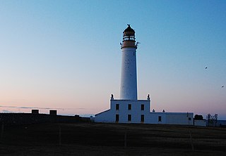
Auskerry is a small island in eastern Orkney, Scotland. It lies in the North Sea south of Stronsay and has a lighthouse, completed in 1866.
The Calf of Eday is an uninhabited island in Orkney, Scotland, lying north east of Eday. It is known for its wildlife and its prehistoric ruins.

The South Orkney Islands are a group of islands in the Southern Ocean, about 604 kilometres (375 mi) north-east of the tip of the Antarctic Peninsula and 844 kilometres (524 mi) south-west of South Georgia Island. They have a total area of about 620 square kilometres (240 sq mi). The islands are claimed both by Britain, and by Argentina as part of Argentine Antarctica. Under the 1959 Antarctic Treaty, sovereignty claims are held in abeyance.

Sule Skerry is a remote skerry in the North Atlantic off the north coast of Scotland.

Gairsay is a small island in Orkney, Scotland, located in the parish of Rendall, 1.5 miles (2.4 km) off the coast, astride one of the approaches to the bays of Firth and Kirkwall. It is about 2 miles (3.2 km) long and 1 mile (1.6 km) wide and includes one conical hill and a small harbour called Millburn Bay, which is sheltered by the peninsula known as the Hen of Gairsay.

The Holm of Papa is a very small uninhabited island in the Orkney Islands. It is around 21 hectares in size. It can be visited from its neighbouring island Papa Westray, or Papay, an island less than a hundred metres west of the Holm.

Burroughston Broch is an Iron Age broch located on the island of Shapinsay in the Orkney Islands, in Scotland. The site overlooks the North Sea on the northeast part of Shapinsay. Excavated in the mid 19th century, Burroughston Broch is still well-preserved. The drystone walls are up to four metres thick in some parts and there is a complete chamber intact off the entrance passage. Some remains of stone fittings are evident in the interior.

Vasa Loch is a brackish lagoon in southwestern Shapinsay, Orkney Islands. This water body has been shown on early maps of the island in a very similar shape and size to its current geometry, separated from the North Sea by a narrow strip of raised beach.(Masters, 1840) Vasa Loch is fed by small rivulets and upland springs that rise on the western part of the island's western spur. pH levels of the loch are strongly alkaline, in the range of 10.15.

Mill Dam is a wetland in western Shapinsay, in Orkney, Scotland.

Mor Stein is a neolithic standing stone in the southeastern part of the island of Shapinsay, Orkney Islands, Scotland. Shapinsay is one of the two large inner islands of the Orkney group, and it is situated approximately two miles north of the Orkney Mainland. Linton Bay is situated slightly to the northeast of Mor Stein.

The Bay of Linton is a bay on the east coast on the island of Shapinsay in the Orkney Islands, Scotland. To the north of Linton Bay are the headlands of Ness of Ork, and to the south is The Foot. The ancient monument the Broch of Burroughston is slightly north of Linton Bay.

Castle Bloody is a prehistoric feature on the island of Shapinsay, Orkney, Scotland. Hogan observes that while the feature is marked as a chambered mound on the UK Ordnance Survey map, the structure is more properly and specifically classified as a souterrain or earth house. Slightly to the north is located the ruined historic Linton Chapel.

Linton Chapel is a ruined chapel on the east coast of Shapinsay, Orkney. The chapel is thought to date as early as the 12th century AD. Slightly to the south is a megalithic monument, Castle Bloody.

Quholm is a hamlet in the northeast of Shapinsay, in the islands of Orkney, Scotland. William Irving, the father of Washington Irving, noted American author, was born in Quholm. Innsker Beach is situated very close by at the northwest edge of Quholm. Slightly to the south along Shapinsay's northwest coast are located the coastal ayres of Lairo Water and the Ouse situated within Veantro Bay. There are significant archaeological sites not distant from Quholm, including Odin's Stone, Burroughston Broch, Linton Chapel, Castle Bloody and Mor Stein.

Eynhallow Sound is a seaway lying between Mainland Orkney and the island of Rousay in the Orkney Islands, Scotland. The tidal indraught is "scarcely felt beyond a line joining Costa Head and the Reef of Quendale". An Iron Age broch, Gurness, has a strategic outlook over the Eynhallow Sound.

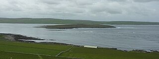
Linga Holm, commonly known as Linga, Midgarth and the Holm of Midgarth is an uninhabited Scottish island extending to approximately 57 hectares (0.22 sq mi) situated 700 metres (770 yd) west of Stronsay island in the Orkney archipelago. The name "Linga Holm" is derived from the Old Norse Lyngholm.

Holm of Grimbister is an inhabited tidal islet in the Orkney archipelago of Scotland. Located in the Bay of Firth near Finstown it is connected to Mainland Orkney by a causeway.

Swan Point is the point on the southwest side of the entrance to Queen Charlotte Bay, forming the northeast extremity of Weddell Island in the Falkland Islands.
