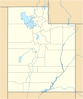
Uintah County is a county in the U.S. state of Utah. As of the 2020 United States Census the population was 35,620. Its county seat and largest city is Vernal. The county was named for the portion of the Ute Indian tribe that lived in the basin.
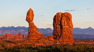
Balanced Rock is one of the most popular features of Arches National Park, situated in Grand County, Utah, United States. Balanced Rock is located next to the park's main road, at about 9.2 miles (14.8 km) from the park entrance. It is one of only a few prominent features clearly visible from the road. The total height of Balanced Rock is 128 feet, with the balancing rock rising 55 feet above the base. This rock is the largest of its kind in the park, weighing approximately 3,577 tons.

Scafell Pike is the highest and the most prominent mountain in England, at an elevation of 978 metres (3,209 ft) above sea level. It is located in the Lake District National Park, in Cumbria, and is part of the Southern Fells and the Scafell massif.

The Wasatch Range or Wasatch Mountains is a mountain range in the western United States that runs about 160 miles (260 km) from the Utah-Idaho border south to central Utah. It is the western edge of the greater Rocky Mountains, and the eastern edge of the Great Basin region. The northern extension of the Wasatch Range, the Bear River Mountains, extends just into Idaho, constituting all of the Wasatch Range in that state.

The Four Corners is a region of the Southwestern United States consisting of the southwestern corner of Colorado, southeastern corner of Utah, northeastern corner of Arizona, and northwestern corner of New Mexico. Most of the Four Corners region belongs to semi-autonomous Native American nations, the largest of which is the Navajo Nation, followed by Hopi, Ute, and Zuni tribal reserves and nations. The Four Corners region is part of a larger region known as the Colorado Plateau and is mostly rural, rugged, and arid.

Marble Canyon is in the south-central Interior of British Columbia, a few kilometres east of the Fraser River and the community of Pavilion, midway between the towns of Lillooet and Cache Creek. The canyon stems from a collapsed karst formation.
Fort George Canyon Provincial Park is a provincial park south of Prince George in British Columbia, Canada. The park's area is 440 acres (180 ha) and includes part of the Fraser River. No camping, campfires, swimming, kayaking, horses, pets, or rock climbing are allowed. Skiing, fishing, and hunting are allowed.

Church Rock is a solitary column of sandstone in southern Utah along the eastern side of U.S. Route 191, near the entrance to the Needles District of Canyonlands National Park.

Horseshoe Canyon, formerly known as Barrier Canyon, is in a remote area west of the Green River and north of the Canyonlands National Park Maze District in Utah, United States. It is known for its collection of Barrier Canyon Style (BCS) rock art, including both pictographs and petroglyphs, which was first recognized as a unique style here. A portion of Horseshoe Canyon containing The Great Gallery is part of a detached unit of Canyonlands National Park. The Horseshoe Canyon Unit was added to the park in 1971 in an attempt to preserve and protect the rock art found along much of its length.

Wall Arch was a natural sandstone arch in Arches National Park in southeastern Utah, United States. Before its collapse in 2008, it was ranked 12th in size among the park's over 2,000 arches. At its largest, the opening underneath the span was 71 feet (22 m) wide by 33.5 feet (10 m) high. It consisted of Entrada Sandstone, specifically the member known as Slick Rock. Wall Arch was first reported and named in 1948 by Lewis T. McKinney.

Arches National Park is a national park in eastern Utah, United States. The park is adjacent to the Colorado River, 4 mi (6 km) north of Moab, Utah. More than 2,000 natural sandstone arches are located in the park, including the well-known Delicate Arch, as well as a variety of unique geological resources and formations. The park contains the highest density of natural arches in the world.
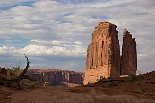
The Courthouse Towers is a collection of tall stone columns located within the Park Avenue section of Arches National Park. The formation was named after its reminiscence to tall buildings in Park Avenue, New York City.

The Fiery Furnace is a collection of narrow sandstone canyons, fins and natural arches located near the center of Arches National Park in Utah, United States.

Fisher Towers are a series of towers made of Cutler sandstone capped with Moenkopi sandstone and caked with a stucco of red mud located near Moab, Utah. The Towers are named for a miner who lived near them in the 1880s. The Towers are world-renowned as a subject for photography and for its classic rock climbing routes.

Raven Ridge is a starkly visible sedimentary rock exposure located in Rio Blanco County, Colorado and Uintah County, Utah, USA. It is managed by the Bureau of Land Management. The ridge contains a diverse selection of rare plants unique to the state of Colorado.
Mollie's Nipple or Molly's Nipple is the name given to as many as seven peaks, at least one butte, at least one well, and some other geological features in Utah. Some sources claim there are eleven geological features in Utah that bear this name. At least some of those names are attributed to John Kitchen – a pioneer of an early exploration of Utah, who named them to commemorate a nipple of his wife Molly.
The Battle of Almendralejo was a battle and massacre in Almendralejo, Spain, in August 1936, during the first stages of the Spanish Civil War.
S.O.B. Hill is a 5,866-foot (1,788 m), summit in San Juan County, Utah, in the United States.