The Rough Bounds

Last updated

The Rough Bounds (Scottish Gaelic : Na Garbh Chriochan), in the Scottish Highlands, is the area of West Inverness-shire bounded by Loch Hourn, Loch Shiel, and Loch Moidart, consisting of the districts of Knoydart, North Morar, Arisaig and Moidart. The area is famous for its wildness and inaccessibility and remains very sparsely populated.

Contents

An anonymous writer in 1750 commented that "all these countries viz. Knoydart, the Two Morrirs, Moydart, and Arisaig, are the most Rough Mountainous and impassible parts in all the Highlands of Scotland, and are commonly called by the Inhabitants of the Neighbouring countries the highlands of the Highlands." [1]

Prehistory

The Re-alignment of a 6 km section of the A830 road in Arisaig led to archaeological investigations in 20002001 by the Centre for Field Archaeology (CFA), University of Edinburgh, and Headland Archaeology  Ltd which found a Bronze Age kerb cairn, turf buildings and shieling huts. The shielings were repeatedly reused through the medieval and post-medieval periods but themselves were on top of Bronze Age remains. Analysis of peat cores revealed a history of continuous but gradual decline in woodland, starting in about 3200 BC and continuing to the present day. [2]

History

Early history

The Arisaig coast The coast at Port nam Murrach, near Arisaig - geograph.org.uk - 17527.jpg
The Arisaig coast

Following raids by Vikings, the Rough Bounds became part of the Kingdom of the Isles, a Norwegian dependency. In the late 11th century, however, Malcolm III of Scotland made a written agreement with Magnus Barelegs, the Norwegian king, which moved the border to the coast; the area thus became Scottish.

In the early 12th century, Somerled, a Norse-Gael of uncertain origin, came into possession of the Rough Bounds and Lorn; no reliable record explains how this happened, but by the 1140s, David I of Scotland's control of the region had been eroded. [3] In the middle of the century, Somerled launched a coup in the Kingdom of the Isles, which resulted in that kingdom joining his other possessions, as a single independent state. Upon Somerled's death, Norwegian authority was restored/established over the areas Somerled had ruled, but in practice the kingdom was divided; the portion containing the Rough Bounds, Uist, and the islands in-between (Eigg and Rhum), became Garmoran , and was ruled by the MacRory, a faction among Somerled's heirs.

The Lordship of Garmoran

Castle Tioram, capital of Garmoran Castle Tioram Ardnamurchan.jpg
Castle Tioram, capital of Garmoran

Following the 1266 Treaty of Perth, Garmoran became a Scottish crown dependency - the Lordship of Garmoran. At the turn of the century, William I had created the position of Sheriff of Inverness, to be responsible for the Scottish highlands, which theoretically now extended to Garmoran. [4] [5] Most of the remainder of the Kingdom of the Isles had become the Lordship of the Isles , ruled by the MacDonalds (another group of Somerled's descendants).

The Lordship of Garmoran remained under the rule of the MacRory, and their descendants - the Siol Gorrie and Clan Ranald. However, violent disputes between the latter two groups lead, in 1427, to king James I executing the leader of the Siol Gorrie, and declaring the Lordship of Garmoran forfeit. [6] This, and the violence, brought the Siol Gorrie to the brink of extinction and they played no further part in regional history. [6]

Lairdship grants

The plain of Mointeach Mhor Mointeach Mhor - geograph.org.uk - 369814.jpg
The plain of Mointeach Mhòr

In 1469, James' grandson (James III) granted Lairdship of the lands of mainland Garmoran and North Uist to John of Ross, the Lord of the Isles. In turn, John passed it to his own half-brother, Hugh of Sleat; the grant to Hugh was confirmed by the king in a 1493 charter. Clan Ranald disputed and fought against the charter.

Following Hugh of Sleat's death, in 1498, and for reasons that are not remotely clear, his son John of Sleat immediately resigned, transferring all authority to the king. By this point, John of Ross's conspiratorial ambition had caused the Lordship of the Isles to be forfeited, but in 1501, his heir, Black Donald, launched an insurrection seeking to restore it. Ranald Bane, leader of Clan Ranald, was one of the few MacDonald-descended clan leaders to refuse to support Donald, so in 1505 (shortly before Donald was defeated) Ranald Bane was given the Lairdship of Arisaig and Eigg, as a reward.

Moidart Bog High boggy basin - geograph.org.uk - 427395.jpg
Moidart Bog

In 1520, the excessive cruelty (not described in detail by surviving records) of Ranald Bane's son, Dougall, led to his assassination, and the exclusion of Ranald Bane's descendants from leadership of Clan Ranald. Instead, Ranald Bane's brother, Alexander, took over the leadership. In 1532, the king provided a charter confirming Alexander's son, John Moidartach, as Laird of Arisaig (and Eigg), and making him Laird of Moidart as well. In 1539, however, the king granted Morar to the MacDonells of Glengarry, rather than to the leaders of Clan Ranald; the MacDonnells of Glengarry were an early cadet branch of Clan Ranald.

At a similar time, the king asserts his right to transfer ownership of Knoydart, on the basis that feudal obligations hadn't been upheld for the previous 70 years; quite why he should argue this if the land had been in royal hands since 1498 is still unclear. His 1537 charter transfers lairdship of Knoydart to Ewen Cameron, the leader of Clan Cameron. 73 years later, in 1611, Allan Cameron, their new leader, transferred it to the Macdonells of Glengarry, consolidating the north-south split of Garmoran between the Clan Ranald and the MacDonells of Glengarry. In 1613, the MacDonnels received official confirmation of ownership from the king. [7]

Law and order

An abandoned house on Morar Ruin at Brinacory - geograph.org.uk - 34929.jpg
An abandoned house on Morar

In 1509, Alexander, the Earl of Huntly, was made sheriff of Inverness, giving him authority in Garmoran; the position was hereditary. In 1540, John Moidartach was imprisoned by James V [note 1] , attempted to give leadership of Clan Ranald to Ranald Gallda [note 2] , uncle of John Moidartach. When the latter was released, in 1542, Ranald Gallda fled, leading to skirmishes between Clan Ranald (led by John Moidartach) and supporters of Ranald Gallda, which only ceased when the Earl of Huntly intervened. In turn, this led to the Battle of the Shirts.

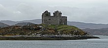
The victory of John Moidartach (and Clan Cameron) in the battle, against the Earl of Huntly and Ranald Gallda, lead to the Earl of Huntly leaving the Rough Bounds alone, and only trying to enforce royal authority in peripheral areas. Nevertheless, when Mary of Guise became regent (for her daughter Mary), in 1554, she ordered an attack on the Rough Bounds. The Campbells attacked Castle Tioram from the sea, but the Earl of Huntly was unwilling to bring troops into the Rough Bounds, and the assault failed.

Blaeu's 1654 map, showing the Rough Bounds' nameless separation from other provinces Blaeu - Atlas of Scotland 1654 - BRAID-ALLABAN - The Central Highlands.jpg
Blaeu's 1654 map, showing the Rough Bounds' nameless separation from other provinces

Over the course of the 16th century, following an inheritance dispute over the lands of MacDonalds of Lochalsh, there were several violent encounters between the MacDonells of Glengarry and the MacKenzies. In 1592, the leader of the MacDonells of Glengarry agreed a contract of mutual aid with the Earl of Huntly. The MacKenzies now sought to complain about MacDonell behaviour in court, but the MacDonell leadership wouldn't turn up, so in 1602, the MacKenzies attacked Morar, leading to the Battle of Morar. Following this, peace agreements reduced the conflict between local clans, and attentions turned to national matters.

A 1689 map showing Loquaber (the Rough Bounds) in green, Lochaber in yellow A new map of Scotland with the roads (8643653080).jpg
A 1689 map showing Loquaber (the Rough Bounds) in green, Lochaber in yellow

In this period, the term Garmoran appears to have dropped out of use. The Earls of Huntly had been granted the adjacent Lordship of Lochaber , in 1500, and Garmoran gradually acquired a perception of being association with it. Yet though a 1669 map names the Rough Bounds as Loquaber, it is clearly marked as outside the borders of Lochaber. The lands formerly of Garmoran remained distinct from Moray and Lochaber even into the 18th century. In Moll's pre-1732 map, the area is clearly distinguished from these neighbouring provinces, but has no name itself, other than the description the territory west from Lochaber. This nameless distinction had already been established in Blaeu's 1654 map, where the lands are simply those that lay west from Lochaber.

The Seven Men of Moidart, commemorating the men who went with Bonnie Prince Charlie into exile The "Seven Men of Moidart" - geograph.org.uk - 4656.jpg
The Seven Men of Moidart, commemorating the men who went with Bonnie Prince Charlie into exile

In 1609, the Statutes of Iona attempted to enforce the Scottish reformation in the highlands, but the Rough Bounds remained resolutely Roman Catholic, [8] and sided with the Royalists during the Civil War. In the following century, the area became a hotbed of Jacobite sympathy, and even resorted to burning down Tioram Castle, in order to prevent it falling into anti-Jacobite hands. Following the failure of the Jacobite rising of 1745, it was the last part of Scotland in which Bonnie Prince Charlie found sanctuary, and the one from which he left for exile in France, on 20 September 1746.

Later history

A succession of flamboyant but unsuccessful chiefs (including especially Alexander Ranaldson MacDonell of Glengarry [1771–1828] and Ranald George Macdonald of Clanranald [1788–1873]) resulted ultimately in the area passing into other hands.

Arisaig House, headquarters for the SOE in Scotland Arisaig House, Borrodale - geograph.org.uk - 66331.jpg
Arisaig House, headquarters for the SOE in Scotland

The Rough Bounds remained difficult to access well into the 20th century; indeed Moidart only received a road connection (the A861) in 1966, and had to be accessed by foot or by ferry. This remoteness made it ideal for practice sites for covert operations in Occupied Europe, during World War II. The Special Operations Executive (SOE) established their Scottish headquarters just outside Arisaig, and constructed paramilitary training bases throughout the region. [9] In Moidart, HMS Dorlin was established, and used for training of Royal Navy Beach Signals and Royal Signals sections.

The remoteness also ensured that the area remained strongly Scottish Gaelic speaking until the mid 20th century. In the 1881 census, with around 90% of the population able to speak Gaelic and over a third unable to speak English. By 2001, the share of Gaelic speakers had declined to under 15% of habitual residents. [10]

Notes

  1. surviving records do not explain why
  2. not to be confused with Ranald Bane

Related Research Articles

<span class="mw-page-title-main">North Uist</span> Island and community in the Outer Hebrides of Scotland

North Uist is an island and community in the Outer Hebrides of Scotland.

<span class="mw-page-title-main">South Uist</span> Island of the Outer Hebrides, Scotland

South Uist is the second-largest island of the Outer Hebrides in Scotland. At the 2011 census, it had a usually resident population of 1,754: a decrease of 64 since 2001. The island, in common with the rest of the Hebrides, is one of the last remaining strongholds of the Gaelic language in Scotland. South Uist's inhabitants are known in Gaelic as Deasaich (Southerners). The population is about 90% Roman Catholic.

<span class="mw-page-title-main">Benbecula</span> Island of the Outer Hebrides, Scotland

Benbecula is an island of the Outer Hebrides in the Atlantic Ocean off the west coast of Scotland. In the 2011 census, it had a resident population of 1,283 with a sizable percentage of Roman Catholics. It is in a zone administered by Comhairle nan Eilean Siar or the Western Isles Council. The island is about 12 kilometres from west to east and a similar distance from north to south. It lies between the islands of North Uist and South Uist and is connected to both by road causeways. Benbecula's main settlement and administrative centre is Balivanich.

<span class="mw-page-title-main">Lochaber</span> Ward management area of the Highland Council

Lochaber is a name applied to a part of the Scottish Highlands. Historically, it was a provincial lordship consisting of the parishes of Kilmallie and Kilmonivaig, as they were before being reduced in extent by the creation of Quoad Sacra parishes in the 19th century. Lochaber once extended from the Northern shore of Loch Leven, a district called Nether Lochaber, to beyond Spean Bridge and Roybridge, which area is known as Brae Lochaber or Braigh Loch Abar in Gaelic. Lochaber is now also used to refer to a much wider area, one of the 16 ward management areas of the Highland Council of Scotland and one of eight former local government districts of the two-tier Highland region. The main town of Lochaber is Fort William.

<span class="mw-page-title-main">Eigg</span> Island of Scotland

Eigg is one of the Small Isles in the Scottish Inner Hebrides. It lies to the south of the Isle of Skye and to the north of the Ardnamurchan peninsula. Eigg is 9 kilometres long from north to south, and 5 km (3 mi) east to west. With an area of 12 sq mi (31 km2), it is the second-largest of the Small Isles after Rùm. Eigg generates virtually all of its electricity using renewable energy.

<span class="mw-page-title-main">Lord of the Isles</span> Title of Scottish nobility

Lord of the Isles or King of the Isles (Scottish Gaelic: Triath nan Eilean or Rìgh Innse Gall) is a title of Scottish nobility with historical roots that go back beyond the Kingdom of Scotland. It began with Somerled in the 12th century and thereafter the title was held by a series of his descendants, the Norse-Gaelic rulers of the Isle of Man and Argyll and the islands of Scotland in the Middle Ages. They wielded sea-power with fleets of galleys (birlinns). Although they were, at times, nominal vassals of the kings of Norway, Ireland, or Scotland, the island chiefs remained functionally independent for many centuries. Their territory included much of Argyll, the Isles of Arran, Bute, Islay, the Isle of Man, Hebrides, Knoydart, Ardnamurchan, and the Kintyre peninsula. At their height they were the greatest landowners and most powerful lords after the kings of England and Scotland.

<span class="mw-page-title-main">Clan Donald</span> Scottish clan

Clan Donald, also known as Clan MacDonald, is a Highland Scottish clan and one of the largest Scottish clans. The Lord Lyon King of Arms, the Scottish official with responsibility for regulating heraldry in that country, issuing new grants of coats of arms, and serving as the judge of the Court of the Lord Lyon, recognises under Scottish law the High Chief of Clan Donald. Historically the chiefs of the Clan Donald held the title of Lord of the Isles until 1493 and two of those chiefs also held the title of Earl of Ross until 1476. Queen Mary of Denmark is member of Clan Donald.

Arisaig is a village in Lochaber, Inverness-shire. It lies 7 miles south of Mallaig on the west coast of the Scottish Highlands, within the Rough Bounds. Arisaig is also the traditional name for part of the surrounding peninsula south of Loch Morar, extending east to Moidart. Etymologically, Arisaig means "safe bay". It lies in the Scottish council area of Highland and has a population of about 300.

<span class="mw-page-title-main">Morar</span> Human settlement in Scotland

Morar is a small village on the west coast of Scotland, three miles south of Mallaig. The name Morar is also applied to the northern part of the peninsula containing the village, though North Morar is more usual. The coastline of the area forms part of the Morar, Moidart and Ardnamurchan National Scenic Area, one of 40 such areas in Scotland, which are defined so as to identify areas of exceptional scenery and to ensure its protection by restricting certain forms of development.

<span class="mw-page-title-main">Clan MacDonell of Glengarry</span> Highland Scottish clan

Clan MacDonell of Glengarry, also known as Clan Ranald of Knoydart & Glengarry is a Scottish clan and is a branch of the larger Clan Donald. The clan takes its name from River Garry where the river Garry runs eastwards through Loch Garry to join the Great Glen about 16 miles (25 km) north of Fort William, Highland. The progenitor of the MacDonells of Glengarry is Reginald, 4th great-grandson of the warrior Somerled. The clan chief is traditionally designated as the "Son of Alexander's son".

Moidart is part of the remote and isolated area of Scotland, west of Fort William, known as the Rough Bounds. Moidart itself is almost surrounded by bodies of water. Loch Shiel cuts off the eastern boundary of the district and continues along part of the southern edge. The remainder of the southern edge is cut off by Loch Moidart. The north is cut off by Loch Morar and Loch Ailort.

<span class="mw-page-title-main">Battle of the Shirts</span> Scottish clan battle that took place in 1544 in the Great Glen, at the northern end of Loch Lochy

The Battle of the Shirts was a Scottish clan battle that took place in 1544 in the Great Glen, at the northern end of Loch Lochy. The Clan Macdonald of Clanranald and their allies the Clan Cameron fought the Clan Fraser and men from Clan Grant. The battlefield has been included and protected by Historic Scotland in their Inventory of Historic Battlefields in Scotland.

<span class="mw-page-title-main">Clan Macdonald of Clanranald</span> Highland Scottish clan

Clan Macdonald of Clanranald, also known as Clan Ranald, is a Highland Scottish clan and a branch of Clan Donald, one of the largest Scottish clans. The founder of the Macdonalds of Clanranald is Reginald, 4th great-grandson of Somerled. The Macdonalds of Clanranald descend from Reginald's elder son Allan and the MacDonells of Glengarry descend from his younger son Donald. The clan chief of the MacDonalds of Clanranald is traditionally designated as The Captain of Clanranald and today both the chief and clan are recognised by the Lord Lyon King of Arms, the heraldic judge in Scotland.

<span class="mw-page-title-main">Clan MacDonald of Keppoch</span> Highland Scottish clan

Clan MacDonald of Keppoch, also known as Clan MacDonellof Keppoch or Clan Ranald of Lochaber, is a Highland Scottish clan and a branch of Clan Donald. The progenitor of the clan is Alistair Carrach MacDonald, 4th great-grandson of the warrior Somerled. The clan chief is traditionally designated as the "Son of Ranald's son".

The Clan MacDonald of Lochalsh was a Scottish family and a branch of the larger Clan Donald.

Garmoran is an area of western Scotland. It lies at the south-western edge of the present Highland Region. It includes Knoydart, Morar, Moidart, Ardnamurchan, and the Small Isles.

<span class="mw-page-title-main">Raid on Ross</span> Scottish conflict in 1491

The Raid on Ross was a conflict that took place in 1491 in the Scottish Highlands. It was fought between the Clan Mackenzie and several other clans, including the Clan MacDonald of Lochalsh, Clan MacDonald of Clanranald, the Clan Cameron, and the Chattan Confederation of Clan Mackintosh.

Amy of Garmoran also known as Amie MacRuari and Euphemia was a 14th-century Scottish noblewoman who was the sister of Raghnall mac Ruaidhri, Lord of Garmoran and the spouse of John of Islay. After her marriage had produced three sons, the ambitious John of Islay divorced her in order to remarry and cement his links with the House of Stewart. She then retired to her estates in the Highlands and Islands, and completed various ecclesiastical and other building projects. Her son Ranald was the progenitor of Clanranald.

Ranald MacDonald was the eponymous ancestor of the MacDonalds of Clanranald and the MacDonells of Glengarry. He was a son of John MacDonald, Lord of the Isles, and his first wife Amie MacRory. John granted Ranald the lands of Garmoran, which he had acquired through his marriage to Amie. This grant may have been a form of compensation for Ranald's exclusion from the main inheritance of the family, which fell to Donald, the eldest son of John's second marriage. The Uists were later detached from Garmoran and given to Ranald's younger brother, Godfrey.

Hugh Fraser, 3rd Lord Lovat was a Scottish peer and Chief of Clan Fraser of Lovat from 1524 until 1544.

References

  1. Rixson, Denis (2002). Arisaig and Morar : a history. East Linton, Scotland: Tuckwell Press. ISBN   1-86232-124-8. OCLC   51108683.
  2. "Vol 15 (2005): Early land-use and landscape development in Arisaig | Scottish Archaeological Internet Reports". journals.socantscot.org. Retrieved 28 July 2021.
  3. MacDonald, IG (2013). Clerics and Clansmen: The Diocese of Argyll between the Twelfth and Sixteenth Centuries. The Northern World: North Europe and the Baltic c. 4001700 AD. Peoples, Economics and Cultures (series vol. 61). Leiden: Brill. ISBN   978-90-04-18547-0. ISSN   1569-1462., p. 37; Woolf, A (2004). "The Age of Sea-Kings, 9001300". In Omand, D (ed.). The Argyll Book. Edinburgh: Birlinn. pp. 94–109. ISBN   1-84158-253-0., p. 102.
  4. Dickinson W.C., The Sheriff Court Book of Fife, Scottish History Society, Third Series, Vol. XII (Edinburgh 1928), pp. 357-360
  5. The Records of the Parliaments of Scotland to 1707, K.M. Brown et al eds (St Andrews, 2007-2017), 15 July 1476
  6. 1 2 Gregory, Donald (1836), History of the Western Highlands and Isles of Scotland, from A.D. 1493 to A.D. 1625, with a brief introductory sketch, from A.D. 80 to A.D. 1493, Edinburgh, W. Tait, retrieved 11 May 2012, p. 65
  7. Dennis Rixson, Knoydart: a history (Birlinn Ltd, Edinburgh, 1999)
  8. Denis Rixson (1999). Knoydart: a history. Edinburgh: Birlinn Ltd. p. 69.
  9. Commando Country, Stuart Allan, National Museums Scotland 2007, ISBN   978-1-905267-14-9
  10. Duwe, Kurt C. "Vol. 01: Àird nam Murchan & Loch Abar an Iar" (PDF). Scottish Gaelic Local Studies. Retrieved 23 April 2017.

Further reading

57°3.5′N5°40′W / 57.0583°N 5.667°W / 57.0583; -5.667