The Settlement, British Virgin Islands

Last updated
The Settlement
Town
GB Virgin Islands.png
British Virgin Islands, The Settlement top right
Coordinates: 18°43′7″N64°19′1″W / 18.71861°N 64.31694°W / 18.71861; -64.31694
Territory British Virgin Islands
Island Anegada
Population
  Estimate 
()
300

The Settlement is the main and only town on Anegada in the British Virgin Islands in the Caribbean.

Contents

The town

The Settlement lies near Lower Bay at the southeastern part of the island and has about 200 inhabitants. The coordinates are 18°43′07″N64°19′01″W / 18.71861°N 64.31694°W / 18.71861; -64.31694 .

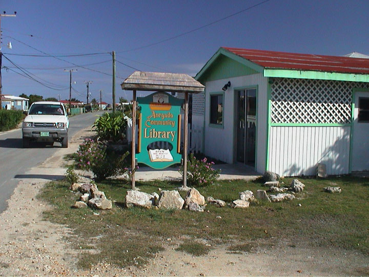
The center of this very small town, often also called "the Village", consists of the area along the main road.

Besides the Government Administration Building, a small medical clinic, a post office, a police building and a library there also are a few restaurants, hotels, and a few small stores. [1]

On the outskirts can be found the Walls, a farming area circled by old stone walls. The enclosed fields were used to grow bananas, maize, sweet potatoes and other crops. [1]

There is also the Iguana Headstart Facility, a breeding farm for iguanas, mainly the Anegada Ground Iguana (or Anegada rock iguana, "Cyclura pinguis"). The farm is managed by the BVI National Parks Trust and the iguanas are released when they are large enough to survive in the wild. [2]

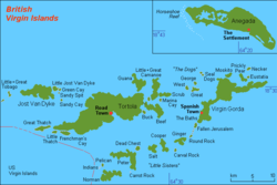
The town's harbor is at Setting Point which is a popular place for sailboats. The harbour has connections with Road Town on Tortola thrice-weekly by ferry.

The town's and the island's airport, the small Auguste George Airport (airport code "NGD"), is about 1 mile northwest of the town.

History

In 1672, Anegada was made part of the British colony Antigua and has been under British control ever since.

San Diego Zoo Global has been running the Anegada Iguana Project since 1992, with the Iguana Headstart Facility being opened in 2003. [3]

Today, tourism is the main income source for the town even though commercial fishing also is a substantial business.

Related Research Articles

<span class="mw-page-title-main">British Virgin Islands</span> British Overseas Territory in the Caribbean

The British Virgin Islands (BVI), officially the Virgin Islands, are a British Overseas Territory in the Caribbean, to the east of Puerto Rico and the US Virgin Islands and north-west of Anguilla. The islands are geographically part of the Virgin Islands archipelago and are located in the Leeward Islands of the Lesser Antilles and part of the West Indies.

<span class="mw-page-title-main">Geography of the British Virgin Islands</span>

The British Virgin Islands (BVI) are one of three political divisions of the Virgin Islands archipelago located in the Lesser Antilles, between the Caribbean Sea and the North Atlantic Ocean. The BVI are the easternmost part of the island chain. The land area totals and comprises 16 inhabited and more than 20 uninhabited islands. The islands of Tortola, Anegada, Virgin Gorda and Jost van Dyke are the largest. Maritime claims include 12 nmi territorial sea and a 200 nmi exclusive fishing zone. In terms of land use, it is 20% arable land, 6.67% permanent crops and 73.33% other as of a 2005 figure. It has strong ties to nearby U.S. Virgin Islands and Puerto Rico.

<span class="mw-page-title-main">History of the British Virgin Islands</span>

The history of the British Virgin Islands is usually, for convenience, broken up into five separate periods:

<span class="mw-page-title-main">Little Cayman</span> One of three Islands that make up the Cayman Islands

Little Cayman is one of three Islands that make up the Cayman Islands. It is located in the Caribbean Sea, approximately 60 miles (96 km) northeast of East End, Grand Cayman and five miles (8 km) west of West End, Cayman Brac. Little Cayman is the least populous island of the three, with a permanent population of about 160 (2021) including seasonal residents/homeowners. The majority of the population are expatriate workers from Jamaica, the Philippines, and Honduras and from other Latin American countries as well as Canada, the USA, India, Australia, Scotland, England, and South Africa. There are a handful of local Caymanians estimated as fewer than 20. It is about 10 miles (16 km) long with an average width of 1 mile (1600 m) and most of the island is undeveloped. Almost the entire island is at sea level. The highest elevation is about 40 feet. The rainy season, which consists of mostly light showers, occurs in Mid-April until June and again in mid-September to mid-October. There will be occasional quick rain showers in the early morning hours. The coolest months are from End of November until Mid March as the cold fronts coming in from the North which the temperature can drop into the low'70s. The Hottest and dryest months are in Summer starting mid-June to mid-September with temperatures between the mid-80s and high 90s. There are no large or predatory or venomous animals that pose a threat to humans.

<span class="mw-page-title-main">Erskine</span> Post town in Renfrewshire, Scotland

Erskine is a town in the council area of Renfrewshire, and historic county of the same name, situated in the West Central Lowlands of Scotland. It lies on the southern bank of the River Clyde, providing the lowest crossing to the north bank of the river at the Erskine Bridge, connecting the town to Old Kilpatrick in West Dunbartonshire. Erskine is a commuter town at the western extent of the Greater Glasgow conurbation, bordering Bishopton to the west and Renfrew, Inchinnan, Paisley and Glasgow Airport to the south. Originally a small village settlement, the town has expanded since the 1960s as the site of development as an overspill town, boosting the population to over 15,000. In 2014, it was rated one of the most attractive postcode areas to live in Scotland.

<span class="mw-page-title-main">Virgin Gorda</span> Island which is part of the British Virgin Islands

Virgin Gorda is the third-largest island and second-most populous of the British Virgin Islands (BVI).

<span class="mw-page-title-main">Anegada</span> Northernmost of the British Virgin Islands

Anegada is the northernmost of the British Virgin Islands (BVI), a group of islands that form part of the archipelago of the Virgin Islands. It lies approximately 15 miles (24 km) north of Virgin Gorda. Anegada is the only inhabited British Virgin Island formed from coral and limestone, rather than being of volcanic origin. While the other islands are mountainous, Anegada is flat and low. Its highest point is only about 28 feet (8.5 m) above sea level, earning it its name, which is the Spanish term for the flooded land, "tierra anegada".

<span class="mw-page-title-main">Tortola</span> Largest of the British Virgin Islands

Tortola is the largest and most populated island of the British Virgin Islands, a group of islands that form part of the archipelago of the Virgin Islands. It has a surface area of 55.7 square kilometres with a total population of 23,908, with 9,400 residents in Road Town. Mount Sage is its highest point at 530 metres above sea level.

<span class="mw-page-title-main">Terrance B. Lettsome International Airport</span> Airport in British Virgin Islands

Terrance B. Lettsome International Airport, previously known as Beef Island Airport, is the main airport serving the British Virgin Islands, a British overseas territory in the Caribbean. The airport serves as the gateway to just about all of the islands within the BVI. The airport is also a gateway for inter-Caribbean travelers headed to the nearby U.S. Virgin Islands. Many travellers fly into Beef Island, with the intention of taking a ferry to the other smaller British Virgin Islands. The airport is located on Beef Island, a small island off the main island of Tortola, to which it is connected by the Queen Elizabeth II Bridge.

<span class="mw-page-title-main">Jamaican iguana</span> Species of lizard

The Jamaican iguana, also known commonly as Colley's iguana, is a large species of lizard in the family Iguanidae. The species is endemic to Jamaica. It is critically endangered, even considered extinct between 1948 and 1990. Once found throughout Jamaica and on the offshore islets Great Goat Island and Little Goat Island, it is now confined to the forests of the Hellshire Hills.

<span class="mw-page-title-main">Fort George, Tortola</span>

Fort George is a colonial fort which was erected on the northeast edge of Road Town, Tortola in the British Virgin Islands above Baugher's Bay. The site is now a ruin.

<span class="mw-page-title-main">Piracy in the British Virgin Islands</span> Piracy in the Caribbean

Piracy in the British Virgin Islands was prevalent during the so-called "Golden Age of Piracy", mainly during the years of 1690-1730. Privateering was also widely practised in the jurisdiction throughout frequent colonial wars, not least by emancipated slaves who, with in preference to back-breaking labour in the fields for pitiful wages, took enormous risks to capture fortunes on the seas with the sanction of the Crown. In 1808, Patrick Colquhoun, a prize agent for the Territory spoke of "the most daring outrages which are frequently committed by people of colour."

<span class="mw-page-title-main">Road Town Fort</span>

Road Town Fort is a colonial fort which was erected on Russell Hill in Road Town, Tortola in the British Virgin Islands above the town's main wharf. In historical records it is sometimes referred to as Fort Road Town. The fort subsequently fell into ruin, and in the 1960s the Bougainvillea clinic was built on top of the old structure. The strong room of the original fort, which was once the Territory's treasury, still survives today, and is now used as a storeroom by the clinic.

Guana Island is an island of the British Virgin Islands (BVI) in the Caribbean. One of the few remaining privately owned islands in its part of the world, Guana has seven white powder-sand beaches and 850 acres (3.4 km2) of tropical forest, mountains, hills, and valleys. The island is mostly natural preserve and has a small resort.

<span class="mw-page-title-main">Whelk Point Fort</span>

The Whelk Point Fort was a colonial fort erected on the southeast part of Tortola in the British Virgin Islands. The fort fell into disrepair and ruin, and relatively little of the original structure remains. In 1992 a house was built over the original foundations of the fort, but the remains of the barracks can still be seen on the land behind the house. The ruins are on private property and are not generally accessible to the public.

<i>Cyclura pinguis</i> Species of reptile

Cyclura pinguis, the Anegada rock iguana, Anegada ground iguana or stout iguana, is a critically endangered species of lizard of the genus Cyclura belonging to the family Iguanidae. The species can be found exclusively in the islands of Anegada and Guana. Historically, it inhabited the islands of Puerto Rico and Saint Thomas; however, the animal's original range has been greatly diminished over prehistory.

<span class="mw-page-title-main">Dutch Virgin Islands</span> Dutch colony in America (1625-1680)

The Dutch Virgin Islands is the collective name for the enclaves that the Dutch West India Company had in the Virgin Islands. The area was ruled by a director, whose seat was not permanent. The main reason for starting a colony here was that it lay strategically between the Dutch colonies in the south and New Netherland. The Dutch West India Company was mainly affected by the competition from Denmark, England and Spain. In 1680 the remaining islands became a British colony.

Air BVI was an airline which operated and was based in the British Virgin Islands (BVI). Founded in 1971, by 1975 it had significantly added capacity to its fleet with the introduction of two Douglas DC-3 aircraft. Air BVI primarily flew between the Beef Island Airport (EIS) on Tortola and Luis Muñoz Marín International Airport in San Juan, Puerto Rico, providing connecting flights to and from major air carriers serving San Juan in order to enable tourists to visit the British Virgin Islands as well as providing transportation for local BVI residents and also served other destinations in the BVI such as Anegada and Virgin Gorda.

<span class="mw-page-title-main">Effects of Hurricane Irma in the British Virgin Islands</span>

The effects of Hurricane Irma in the British Virgin Islands were significant in terms of both human and socio-economic impact on the Territory. Hurricane Irma struck the British Virgin Islands as a Category 5 hurricane during the daylight hours of Wednesday, 6 September 2017. It caused widespread destruction, and killed a total of four people. The eye of the hurricane traveled over the three major islands in the group: Virgin Gorda, Tortola and Jost Van Dyke.

References

  1. 1 2 "Anegada--the Drowned Island in the BVI". www.b-v-i.com.
  2. "Archived copy". Archived from the original on 2007-10-08. Retrieved 2008-01-10.{{cite web}}: CS1 maint: archived copy as title (link)
  3. http://cres.sandiegozoo.org/projects/rb_iguanas_caribb.html