The Talbot, Stow-on-the-Wold

Last updated

The Talbot, Stow-on-the Wold
The Talbot, Stow-on-the-Wold (geograph 7469665).jpg
The Talbot, Stow-on-the Wold
LocationMarket Square, Stow-on-the-Wold
Coordinates 51°55′47″N1°43′21″W / 51.9298°N 1.7226°W / 51.9298; -1.7226
Built1714
Architectural style(s) Vernacular style
Listed Building – Grade II
Official nameThe Talbot Hotel (and rear extensions)
Designated3 March 1982
Reference no.1088797
Gloucestershire UK location map.svg
Red pog.svg
Shown in Gloucestershire

The Talbot, formerly known as The Talbot Hotel, is a public house in the Market Square in Stow-on-the-Wold, Gloucestershire, England. The structure, which was originally a coaching inn and later served as the local corn exchange as well as the main hotel in the town, is a Grade II listed building. [1]

Contents

History

The Talbot was originally conceived as a coaching inn with stables in the street behind. It was designed in the vernacular style, built in rubble masonry in around 1714. [2] [3] In the 1840s, the building began to serve as the local corn exchange and, at that time, the left-hand section of three bays was refaced in ashlar stone such that it slightly projected forward onto the Market Square. The new façade was fenestrated with sash windows on all three floors with hood moulds above each window and a parapet at roof level. Meanwhile, the right-hand section of two bays remained faced in rubble masonry with more basic finishes. [1]

A brass letter box was installed between the windows on the ground floor to enable corn merchants to post their weekly corn returns: these returns informed the weekly summary of local corn trades published in national newspapers. [4] [5] In the second half of the 18th century, the hotel proprietor was Richard Day and it was branded "Day's Talbot Hotel". [6] [7]

The use of the building as a corn exchange declined significantly in the wake of the Great Depression of British Agriculture in the late 19th century. [8] However, the building continued to provide lodging for customers and to serve as a regular meeting place for local farmers, [9] and for the local masonic lodge. [10] An extensive programme of repairs was carried out, following a serious fire in the building in February 1870. [11]

The hotel was acquired by Hitchman's Brewery of Chipping Norton in the late 19th century, before passing to Hunt Edmunds Brewery of Banbury in 1925. [12] It came into the ownership of Bass Charrington in the 1960s, [13] by which time it was the largest hotel in the town. [2] It was subsequently acquired by Wadworths of Devizes in 1985. [11]

See also

Related Research Articles

<span class="mw-page-title-main">Cotswolds</span> Protected area mostly in South West England

The Cotswolds is a region in central, South East, but predominantly South West England, along a range of rolling hills that rise from the meadows of the upper River Thames to an escarpment above the Severn Valley, Bath and Evesham Vale.

<span class="mw-page-title-main">Stow-on-the-Wold</span> English market town in Gloucestershire

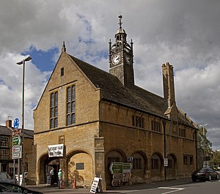
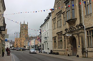
Stow-on-the-Wold is a market town and civil parish in Gloucestershire, England, on top of an 800-foot hill at the junction of main roads through the Cotswolds, including the Fosse Way (A429), which is of Roman origin. The town was founded by Norman lords to absorb trade from the roads converging there. Fairs have been held by royal charter since 1330; a horse fair is still held on the edge of town nearest to Oddington in May and October each year.

<span class="mw-page-title-main">Oxfordshire</span> County of England

Oxfordshire is a ceremonial county in South East England. The county is bordered by Northamptonshire and Warwickshire to the north, Buckinghamshire to the east, Berkshire to the south, and Wiltshire and Gloucestershire to the west. The city of Oxford is the largest settlement and county town.

<span class="mw-page-title-main">Moreton-in-Marsh</span> Town in Gloucestershire, England

Moreton-in-Marsh is a market town in the Evenlode Valley, within the Cotswolds district and Area of Outstanding Natural Beauty in Gloucestershire, England.

<span class="mw-page-title-main">Cotswold District</span> Non-metropolitan district in England

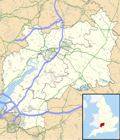
Cotswold is a local government district in Gloucestershire, England. It is named after the wider Cotswolds region and range of hills. The council is based in the district's largest town of Cirencester. The district also includes the towns of Chipping Campden, Fairford, Lechlade, Moreton-in-Marsh, Northleach, Stow-on-the-Wold and Tetbury, along with numerous villages and surrounding rural areas.

<span class="mw-page-title-main">Chipping Norton</span> Market town in West Oxfordshire, England

Chipping Norton is a market town and civil parish in the Cotswold Hills in the West Oxfordshire district of Oxfordshire, England, about 12 miles (19 km) south-west of Banbury and 18 miles (29 km) north-west of Oxford. The 2011 Census recorded the civil parish population as 5,719. It was estimated at 6,254 in 2019.

<span class="mw-page-title-main">The Cotswolds (UK Parliament constituency)</span> Parliamentary constituency in the United Kingdom, 1997 onwards

The Cotswolds is a constituency in Gloucestershire represented in the House of Commons of the UK Parliament by Sir Geoffrey Clifton-Brown, a Conservative, since its 1997 creation.

<span class="mw-page-title-main">Northleach</span> Market town in England

Northleach is a market town and former civil parish, now in parish Northleach with Eastington, in the Cotswold district, in Gloucestershire, England. The town is in the valley of the River Leach in the Cotswolds, about 10 miles (16 km) northeast of Cirencester and 11 miles (18 km) east-southeast of Cheltenham. The 2011 Census recorded the parish's population as 1,854, the same as Northleach built-up-area.

<span class="mw-page-title-main">Bledington</span> Human settlement in England

Bledington is a village and civil parish in the Cotswold district of Gloucestershire, England, about four miles southeast of Stow-on-the-Wold and six miles southwest of Chipping Norton. The population of the civil parish in 2014 was estimated to be 490.

<span class="mw-page-title-main">Corn exchange</span> Building where farmers and merchants traded cereal grains

A corn exchange is a building where merchants trade grains. The word "corn" in British English denotes all cereal grains, such as wheat and barley; in the United States these buildings were called grain exchange. Such trade was common in towns and cities across England until the 19th century, but as the trade became centralised in the 20th century many such buildings were used for other purposes. Several have since become historical landmarks.

<span class="mw-page-title-main">Guy Dawber</span> English architect (1861–1938)

Sir Edward Guy Dawber, RA was an English architect working in the late Arts and Crafts style, whose work is particularly associated with the Cotswolds.

<span class="mw-page-title-main">St Edward's Church, Stow-on-the-Wold</span> Church in Stow-on-the-Wold, England

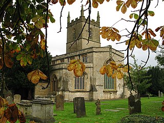
St Edward's Church is a medieval-built Church of England parish church, serving Stow-on-the-Wold ('Stow'), Gloucestershire.

<span class="mw-page-title-main">Upper Slaughter</span> Human settlement in England

Upper Slaughter is a village in the Cotswold district of Gloucestershire, England, 4 miles (6.4 km) south west of Stow-on-the-Wold. The village lies off the A429, which is known as the Fosse Way, and is located one mile away from its twin village Lower Slaughter, as well as being near the villages Bourton-on-the-Water, Daylesford, Upper Swell and Lower Swell. As of 2021, the village had a population of 181 inhabitants, an increase of 4 from 2011.

<span class="mw-page-title-main">Donnington Brewery</span> Small brewery in England

The Donnington Brewery is a small brewery near the village of Donnington near Stow-on-the-Wold in Gloucestershire, England.

<span class="mw-page-title-main">Maugersbury</span> Human settlement in England

Maugersbury is a village and civil parish in Gloucestershire, England. Situated less than a mile south-east of the market town of Stow-on-the-Wold and approximately 18 miles (29 km) east of its post town, Cheltenham, Maugersbury lies within the Cotswolds, an Area of Outstanding Natural Beauty. At the 2001 United Kingdom census, the parish had a population of 149.

<span class="mw-page-title-main">Corn exchanges in England</span> Commodity trading halls in England

Corn exchanges are distinct buildings which were originally created as a venue for corn merchants to meet and arrange pricing with farmers for the sale of wheat, barley, and other corn crops. The word "corn" in British English denotes all cereal grains, such as wheat and barley. With the repeal of the Corn Laws in 1846, a large number of corn exchanges were built in England, particularly in the corn-growing areas of Eastern England.

<span class="mw-page-title-main">Cornhill Corn Exchange, Banbury</span> Commercial building in Banbury, England

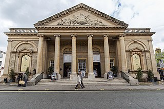
The Cornhill Corn Exchange was a commercial building in the Market Place, Banbury, Oxfordshire, England. The façade of the building, which has been preserved and now forms an entrance to a shopping centre, is a Grade II listed building.

<span class="mw-page-title-main">Corn Exchange, Faringdon</span> Commercial building in Faringdon, Oxfordshire, England

The Corn Exchange is a commercial building in Gloucester Street in Faringdon, Oxfordshire, England. The structure, which is currently used as a community events venue, is a Grade II listed building.

<span class="mw-page-title-main">Corn Exchange, Melrose</span> Commercial building in Melrose, Scotland

The Corn Exchange is a commercial building in the Market Square in Melrose, Scottish Borders, Scotland. The structure, which is now used as a public events venue, is a Category B listed building.

<span class="mw-page-title-main">Corn Exchange, Market Rasen</span> Commercial building in Market Rasen, Lincolnshire, England

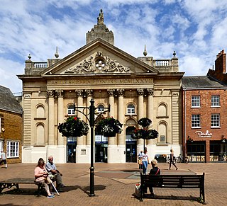
The Corn Exchange is a commercial building in Queen Street, Market Rasen, Lincolnshire, England. The structure, which is used as the offices of a firm of charted surveyors, is a Grade II listed building.

References

  1. 1 2 Historic England. "The Talbot Hotel (and rear extensions) (1088797)". National Heritage List for England . Retrieved 25 July 2023.
  2. 1 2 Elrington, C. R. (1965). "'Parishes: Stow-on-the-Wold', in A History of the County of Gloucester". London: British History Online. pp. 142–165. Retrieved 25 July 2023.
  3. Pevsner, Nikolaus (1970). Gloucestershire: The Cotswolds (Buildings of England Series). Penguin Books. p. 425.
  4. "Corn Returns Act 1882". Legislation.co.uk. Retrieved 25 July 2023.
  5. "The Talbot". Stow Civic Society. Retrieved 25 July 2023.
  6. Edgell, Tim (2010). "Cotswold Pubs and Breweries". Amberly Publishing. ISBN   978-1445627571.
  7. "A List of the Lodges Comprising the Independent Order of Oddfellows, Manchester Unity, Friendly Society, with a Table of the Lodge Nights". The Independent Order of Odd Fellows. 1880. p. 45.
  8. Fletcher, T. W. (1973). 'The Great Depression of English Agriculture 1873-1896' in British Agriculture 1875-1914. London: Methuen. p. 31. ISBN   978-1136581182.
  9. "Cotswold Sunday School Union". The Sunday School Chronicle. 20 April 1877. p. 209. Retrieved 25 July 2023.
  10. "Reports of the Chief Registrar of Friendly Societies". House of Commons. 14 August 1877. p. 225.
  11. 1 2 "Talbot Hotel, Market Square, Stow-on-the Wold". Gloucestershire Pubs. 31 March 2022. Retrieved 25 July 2023.
  12. "The Brewing Industry A Guide to Historical Records". Manchester University Press. 1990. p. 181. ISBN   9780719030321.
  13. Little, Brian (2003). Banbury: A History. Chichester: Phillimore & Co. pp. 104–105. ISBN   978-1860772429.