Kootanae House, also spelled Kootenae House, was a North West Company fur trading post built by Jaco Finlay under the direction of David Thompson near present-day Invermere, British Columbia in 1807. It was abandoned in 1812. In 1808 Thompson reckoned its location as 50°32′12″N115°56′15″W. The actual location is Kootenae House National Historic Site, located at 50.526624°N 116.045440°W.

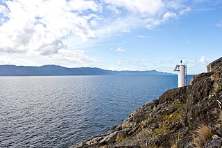
Bute Inlet is one of the principal inlets of the British Columbia Coast. It is 80 km long from the estuaries of the Homathko and Southgate Rivers at the head of the inlet, to the mouth, where it is nearly blocked by Stuart Island, and it averages about 4 km in width. Bute Inlet is in a spectacular wilderness setting and is one of the most scenic waterways in the world. In the upper reaches of the inlet mountains rise 9000 feet above sea level. Bute Inlet is a spectacular wilderness that is visited by very few people. In more recent years tourists are travelling from around the world to view grizzly bears in a natural setting and explore the wilderness of Bute Inlet.
Bishop River Provincial Park is a provincial park in the Pacific Ranges of the Coast Mountains on the Mainland of British Columbia, Canada, located southwest of and adjoining Ts'yl-os Provincial Park."Bishop River Park". BC Geographical Names. It lies along the upper course of the Bishop River, the main tributary of the Southgate River, from the Bishop's source at the western side of the Lillooet Icecap to midway along its course above its confluence with the Southgate. The park is 19,947 ha. in size. There are no roads or trails in the park although a forest service road from Waddington Harbour at the head of Bute Inlet leads up the Southgate to within a few miles of the park boundary.
Canal Flats Provincial Park was a provincial park in British Columbia, Canada, located at Canal Flats at the divide between Columbia Lake and the Kootenay River in the province's East Kootenay region. The park had been established in 1981 at approximately 6 hectares in size. In 2004, the park was converted from Order In Canada to Statute Designation and the size remained at approximately 6 hectares. The park status was cancelled in 2010 and the property is currently pending transfer to local government jurisdiction.
Francis Point Provincial Park is a provincial park in British Columbia, Canada, located on the southwest end of the Francis Peninsula, south of the community of Pender Harbour on the west side of the Sechelt Peninsula in the Sunshine Coast region. Established in 2004, the park is 81 ha. in size, 72 ha. of it upland, the other 9 ha. foreshore.
Homathko Estuary Provincial Park is a provincial park in British Columbia, Canada, located at the head of Bute Inlet surrounding the mouth of the Homathko River in the Pacific Ranges of the Coast Mountains.
Prophet River Hotsprings Provincial Park is a provincial park in British Columbia, Canada. Established high in the Muskwa Ranges, on the course of the Prophet River, it is part of the larger Muskwa-Kechika Management Area.
Scatter River Old Growth Provincial Park is a provincial park in British Columbia, Canada, located on the Liard River downstream from Liard River Hot Springs Provincial Park and Liard River Corridor Provincial Park and Protected Area. The park includes the Grand Canyon of the Liard, a 30km stretch of canyon and whitewater between the Toad and Trout River confluences with the Liard. The park includes high upland plateau and muskeg as well as stands of old growth spruce forests. Established in 1999, the park is c.1140 ha. in area.
The Powell River is a river in the northern Sunshine Coast region of British Columbia, Canada that flows a short distance through the eponymous city of Powell River, British Columbia to enter the Salish Sea. It is one of the shortest rivers in the world, along with the Nautley River.
Little River is a community in the Comox Valley region of Vancouver Island, British Columbia, Canada.
The Compton Névé is an icefield in the Pacific Ranges of the Coast Mountains in southwestern British Columbia, Canada, located southeast of the Homathko Icefield and Mount Gilbert and to the south of the Bishop River. It lies west of the Lillooet Icecap and is connected to it by the Ring Glacier, which sits astride Ring Pass, the divide between the Lillooet and Bishop Rivers, and has an area of 714 km2 (276 sq mi).
The Little River is a tributary of Little River Bay in the Comox Valley region of Vancouver Island, British Columbia, Canada and the namesake of the community of Little River. Little River Bay is a sidewater of the Strait of Georgia.
Theodosia Inlet is an inlet in the Desolation Sound region of the South Coast region of British Columbia, Canada, located east of Lancelot Inlet, a sub-inlet of Malaspina Inlet. The inlet is fed by the Theodosia River. The locality of Theodosia Arm is located near its outlet at the head of Thors Cove.
Theodosia Arm is a locality in the Desolation Sound area of the South Coast region of British Columbia, Canada, located at the head of Thors Cove, a sidewater of Malaspina Inlet, near the outlet of Theodosia Inlet
Malaspina Inlet is an inlet on the east side of Desolation Sound in the South Coast region of British Columbia, Canada, located between Malaspina and Gifford Peninsulas. Sidewaters include Thors Cove and, via it, Theodosia Inlet, where the locality of Theodosia Arm is located. The upper, southeastern, end of Malaspina Inlet near the City of Powell River is called Okeover Inlet. on the east side of which the steamer landing Larsons Landing is located. Grace Harbour is located on north side of Malaspina Inlet on the southwest side of Gifford Peninsula.
The Gifford Peninsula is a peninsula on the east side of Desolation Sound in the Sunshine Coast region of the South Coast of British Columbia, Canada, located immediately north of the Malaspina Peninsula and separated from it by Malaspina Inlet. On its east side is Lancelot Inlet and its sidewater Theodosia Inlet
Lancelot Inlet is an inlet in the Sunshine Coast region of the South Coast of British Columbia, Canada. It is a sidewater of Malaspina Inlet, and immediately east of the Gifford Peninsula. Via Thors Cove on its east side, its own sidewater is Theodosia Inlet, at the head of which is the mouth of the Theodosia River. The locality of Theodosia Arm is located here.
Okeover Inlet, formerly Okeover Arm, is an inlet in the Sunshine Coast region of the southwestern mainland of British Columbia, Canada. It is the upper end of Malaspina Inlet and is northwest of the City of Powell River. Larsons Landing, a steamer landing, is located on its eastern shore.
Waddington Harbour is a harbour at the head of Bute Inlet in the Central Coast region of British Columbia, Canada. Also issuing into the head of Bute Inlet and Waddington Harbour, just west of the mouth of the Homathko, is the Teaquahan River. Issuing directly into the inlet a few miles south on the harbour's southeast is the Southgate River, one of the major rivers of the central Pacific Ranges, which begins on the west side of the Lillooet Icecap. Its lower valley adjacent to the inlet's shores is called Pigeon Valley.
The Bishop River is a river in the Pacific Ranges of the Coast Mountains, flowing west from the western edge of the Lillooet Icecap to join the Southgate River east of the Homathko Icefield. Bishop River Provincial Park surrounds the upper course of the river, from the source at the Lillooet Icecap to midway along its course above its confluence with the Southgate.


