Thiobon

Last updated
Thiobon
Village
Senegal adm location map.svg
Red pog.svg
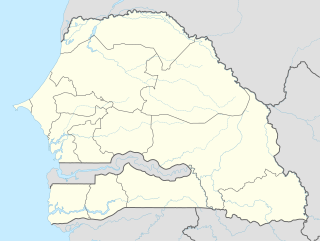
Thiobon
Location in Senegal
Coordinates: 12°52′30″N16°32′57″W / 12.8750°N 16.5492°W / 12.8750; -16.5492 Coordinates: 12°52′30″N16°32′57″W / 12.8750°N 16.5492°W / 12.8750; -16.5492
Country Flag of Senegal.svg  Senegal
Region Ziguinchor
Department Bignona
Arrondissment Tendouck
Elevation 6 m (20 ft)
Population (2002) 1,387

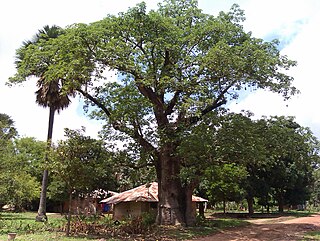
Thiobon is a village of Senegal, located in lower Casamance, in the northeast of the subprefecture of Tendouck, 42 km from Bignona and 72 km from Ziguinchor. It is part of the Kartiack Rural community, in Tendouck Arrondissement, Bignona Department, Ziguinchor.

Senegal republic in Western Africa

Senegal, officially the Republic of Senegal, is a country in West Africa. Senegal is bordered by Mauritania in the north, Mali to the east, Guinea to the southeast, and Guinea-Bissau to the southwest. Senegal also borders The Gambia, a country occupying a narrow sliver of land along the banks of the Gambia River, which separates Senegal's southern region of Casamance from the rest of the country. Senegal also shares a maritime border with Cape Verde. Senegal's economic and political capital is Dakar.

Casamance Geographical region in Senegal

Casamance is the area of Senegal south of the Gambia including the Casamance River. It consists of the Lower Casamance and the Upper Casamance. The largest city of Casamance is Ziguinchor.

A subprefecture is an administrative division of a country that is below prefecture or province.

Contents

Creeks separate the village is from Baïla to the north and from Diouloulou and the islands of Carones and Carabane to the west. It is bordered on the south by the village of Mlomp and on the east by the village of Kartiack. Thiobon includes several uninhabited islands (Diadédiome, Koudièle, Djiyinène, Kayène-hourer, Kahahène, Diendiènaye, Kareugheul, Taminang, Houtanghate-Kouseumpoul, Houssoudia, Mainduènou) where rice farming is carried out and bird nesting site called Houlèouteuhou. Thiobon can be accessed by river or by road (Boucle du Blouf).

Baïla Village in Ziguinchor, Senegal

Baïla is a village in the rural community of Suelle, Sindian, Bignona, Ziguinchor, Casamance, Senegal.

Diouloulou Town and commune in Ziguinchor, Senegal

Diouloulou is a small town and commune in the Bignona Department of the Ziguinchor Region of southwestern Senegal. In 2002 the town had a population of 2725 people.

Carabane Village in Senegal

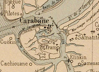
Carabane, also known as Karabane, is an island and a village located in the extreme south-west of Senegal, in the mouth of the Casamance River. This relatively recent geological formation consists of a shoal and alluvium to which soil is added by accumulation in the branches and roots of the mangrove trees which cover most of the island. Along with the rest of Ziguinchor Region, Carabane has a tropical climate, cycling between a dry season and a wet season. The island was once considered an arid location where no useful plants were likely to grow, but it now supports several types of fruit tree, the most common of which are mangos and oranges. Although the nearby Basse Casamance National Park and Kalissaye Avifaunal Reserve have been closed for years because of the Casamance Conflict, Carabane has continued to attract ornithologists interested in its wide variety of birds. Various species of fish are plentiful around the island, but there are very few mammals.

The town is made up of five quarters: Amanque, Dablé, Erindian, Kabine and Kafone.

Population

In the last census (2002), the village contained 1,387 inhabitants and 193 households. [1] The main religion is Islam and the main economic activities are agriculture, animal husbandry, fishing, handicrafts and commerce.

Islam is an Abrahamic monotheistic religion teaching that there is only one God (Allah), and that Muhammad is the messenger of God. It is the world's second-largest religion with over 1.8 billion followers or 24% of the world's population, most commonly known as Muslims. Muslims make up a majority of the population in 50 countries. Islam teaches that God is merciful, all-powerful, unique and has guided humankind through prophets, revealed scriptures and natural signs. The primary scriptures of Islam are the Quran, viewed by Muslims as the verbatim word of God, and the teachings and normative example of Muhammad.

Agriculture Cultivation of plants and animals to provide useful products

Agriculture is the science and art of cultivating plants and livestock. Agriculture was the key development in the rise of sedentary human civilization, whereby farming of domesticated species created food surpluses that enabled people to live in cities. The history of agriculture began thousands of years ago. After gathering wild grains beginning at least 105,000 years ago, nascent farmers began to plant them around 11,500 years ago. Pigs, sheep and cattle were domesticated over 10,000 years ago. Plants were independently cultivated in at least 11 regions of the world. Industrial agriculture based on large-scale monoculture in the twentieth century came to dominate agricultural output, though about 2 billion people still depended on subsistence agriculture into the twenty-first.

Animal husbandry Management, selective breeding, and care of farm animals by humans

Animal husbandry is the branch of agriculture concerned with animals that are raised for meat, fibre, milk, eggs, or other products. It includes day-to-day care, selective breeding and the raising of livestock.

Social organisation

The village is structured around an association, a GIE, and a women's group (GPF).

A Groupement d'intérêt économique is a Francophone consortium of related businesses, companies, foundations, organisations or institutes which are formally pooling their efforts for competitive advantage. Most partners come from the private sector but inclusion of public sector partners is not unusual.

The Association pour la Rénovation de Thiobon (ASSORETH) is the largest structure of the group because it contains residents and citizens. The members meet annually in a general assembly at which the problems facing the village are discussed and solutions are proposed. The association is funded solely by contributions from its members which are fixed at ten thousand CFA francs waged and a thousand CFA francs unwaged. These contributions are used by the village to carry out projects in the areas of education, health, etc.

CFA franc two African currencies

The CFA franc is the name of two currencies, the West African CFA franc, used in eight West African countries, and the Central African CFA franc, used in six Central African countries. Both currencies are guaranteed by the French treasury. Although separate, the two CFA franc currencies have always been at parity and are effectively interchangeable. The ISO currency codes are XAF for the Central African CFA franc and XOF for the West African CFA franc.

In order to attain its economic, social and cultural development objectives, the village of Thiobon held its first cultural festival from 24 to 31 December 2011. This initiative was intended to reinforce the unity of the village youth.

Following the success of this festival, the village decided to make it an annual event. It was held for the second time from 2 to 4 April 2013, during the Easter holiday, immediately after ASSORETH's general assembly. The new date reflected feedback received from the first event - December coincides with the harvest and this had reduced the ability of women to participate in the daytime activities of the first event. The theme of the second event was "Peace and Protection of the Environment for the Development of Casamance."

Related Research Articles

Casamance conflict ongoing low-level conflict between the Government of Senegal and the Movement of Democratic Forces of Casamance (MFDC) since 1982; unilateral ceasefire on May 1, 2014.

The Casamance conflict is an ongoing low-level conflict that has been waged between the Government of Senegal and the Movement of Democratic Forces of Casamance (MFDC) since 1982. On May 1, 2014 the leader of the MFDC sued for peace and declared a unilateral ceasefire.

Trans-Gambia Highway road in The Gambia and Senegal

The Trans-Gambia Highway is the most important road in The Gambia, running across the centre of the nation in a north-south direction.

The Jola are an ethnic group found in Senegal, the Gambia, and Guinea-Bissau. There are great numbers on the Atlantic coast between the southern banks of the Gambia River, the Casamance region of Senegal and the northern part of Guinea-Bissau.In the 1880s the Jolas were engaged in palm wine tapping in Bathurst. By the end of the 19th century some Jola had moved to producing groundnuts as a cash crop and during the Second World War had expanded greatly. They also reared livestock and produced other crops including sweet potatoes, yams and watermelon. The Jola language is distinct from the Dioula language of the Dioula (Dyoula) Mande people of the Gambia, Upper Niger and the Kong highlands of Burkina Faso.

Father Augustin Diamacoune Senghor was a Roman Catholic priest and a leading figure in the Casamance independence movement from Senegal. He served as director of the Saint-Louis of Ziguinchor Seminary from 1972 until 1975.

Mpack, Senegal Town in Ziguinchor Region, Senegal

Mpack is a village in Niaguis Arrondissement, Ziguinchor Department, Ziguinchor Region in southern Senegal. Government statistics classified it as a rural community and recorded its population as 518 people in 72 households. It is located about seven kilometres from the regional capital of Ziguinchor. It is one of the endpoints of the 90-km long Oussouye-Kabrousse-Cap Skirring-Ziguinchor-Mpack road, which is being rebuilt with 17 billion CFA francs of funding from the European Union. The village used to be on the front lines of the Casamance Conflict between the Senegalese government and the Movement of Democratic Forces of Casamance.

Mlomp Rural community and village in Ziguinchor Region, Senegal

Mlomp is a rural community and village in the Ziguinchor Region of Senegal in the Casamance, situated approximately 40 km (25 mi) south-west of Ziguinchor.

Elinkine Town in Ziguinchor, Senegal

Elinkine is a town in Casamance, Senegal, located at the mouth of the Casamance River, 35 kilometres (22 mi) from Oussouye.

Cachouane Town in Ziguinchor, Senegal

Cachouane is a town in Basse Casamance, southern Senegal, located in the mouth of the Casamance River, south of the island of Carabane.

Kabrousse Town in Ziguinchor, Senegal

Kabrousse is a village in the rural community of Diembéring, Oussouye, Ziguinchor, Casamance, Senegal.

Thionck Essyl Town in Ziguinchor, Senegal

Thionck Essyl is a town in Ziguinchor, Senegal, located 65 km north-west of the region capital.

Abéné Village in Ziguinchor, Senegal

Abéné is a village in the rural community of Kafountine, Kataba Arrondissement, Bignona Department, Ziguinchor Region in the Basse Casamance area of south-west Senegal. It is located on the Atlantic coast.

Agnam Lidoubé is a sahelian village in the north-east of Senegal located to the east of the village of Agnam-Goly. It had a population of 362 people according to the 2002 census.

Aly is a small town in Senegal on the left bank of the Senegal river 39 km downstream from Matam in the Daande Maayo area. It had a population of 2,347 people in 2010 and a population of 1,651 according to the 2002 census.

Bagaya Village in Ziguinchor Region, Senegal

Bagaya is a settlement in Senegal in the department Bignona, in the region Ziguinchor Region, in the Casamance area. Bagaya belongs to the rural community of Balinghore in the arrondissement of Tendouck. It is located on the road from Bignona to Elana between Mandégane and Diatock.

Ziguinchor Commune in Ziguinchor Region, Senegal

Ziguinchor is the capital of the Ziguinchor Region, and the chief town of the Casamance area of Senegal, lying at the mouth of the Casamance River. It has a population of over 230,000. It is the second largest city of Senegal, but largely separated from the north of the country by The Gambia.

Mlomp, Bignona Village in Ziguinchor, Senegal

Mlomp is a village in Lower Casamance, Senegal, located to the north of Thionck Essyl and to the south of Kartiack. At the time of the 2002 census, the locality contained 2,746 in 382 households. It is the main settlement of the rural community of Mlomp (Bignona), in Bignona Department of the Ziguinchor Region.

References