
Labrador is a geographic and cultural region within the Canadian province of Newfoundland and Labrador. It is the primarily continental portion of the province and constitutes 71% of the province's area but is home to only 6% of the province's population. It is separated from the island of Newfoundland by the Strait of Belle Isle. It is the largest and northernmost geographical region in Atlantic Canada.

Dildo is a local service district and designated place in the Canadian province of Newfoundland and Labrador on the island of Newfoundland. It is located on the southeastern Dildo Arm of Trinity Bay about 60 kilometres (37 mi) west of St. John's. South Dildo is a neighbouring community of 250 residents. The town's unusual name has brought it a certain amount of notoriety.

Grand Bank or 'Grand Banc' as the first French settlers pronounced it, is a small rural town in the Canadian province of Newfoundland and Labrador, with a population of 2,580. It is located on the southern tip or "toe" of the Burin Peninsula, 360 km from the province's capital of St. John's.

Belleoram is a village on the shores of Fortune Bay in the Canadian province of Newfoundland and Labrador.
Baie Verte is a town located on the north coast of the island portion of the Canadian province of Newfoundland and Labrador on the Baie Verte Peninsula.
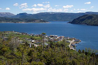
Springdale is a town in Newfoundland and Labrador, Canada, which had a population of 2,971 people in 2016, up from 2,764 in the Canada 2006 Census. The community is located on the Northwestern shores of Hall's Bay in Central Newfoundland, near the mouth of Indian River.
Woody Point is a town located in the heart of Gros Morne National Park, on the western coast of Newfoundland. Situated on Bonne Bay, the Town of Woody Point encompasses three areas: Curzon Village, Woody Point and Winterhouse Brook. It has a total population of 281 residents. Woody Point is a Registered Heritage District and has a waterfront with many heritage buildings and four Registered Newfoundland and Labrador Heritage Structures. The community is served by Route 431.

Tilt Cove is a town located southeast of Baie Verte on Notre Dame Bay and was founded in 1813. With an official population of 5 at the 2016 census, Tilt Cove is known as "Canada's smallest town." A source of gold, copper, and zinc ores, Tilt Cove was the site of the first mine in Newfoundland. The Tilt Cove mine opened in 1864 and "was soon employing several hundred men at good wages". Postal service was established in 1869.

Trout River is a small rural fishing village located on the southern coastal edge of Gros Morne National Park in Newfoundland, near the Tablelands. Trout River was settled in 1815 by George Crocker and his family, who were its only inhabitants until 1880. The community is served by Route 431.

Harbour Breton is a small fishing community on the Connaigre Peninsula in Fortune Bay, on the south coast of the island of Newfoundland in Canada. It is the largest center on the Connaigre Peninsula and was long considered the unofficial capital of Fortune Bay. Many residents resettled from Sagona Island, Jersey Harbour, Little Bay West, Miller's Passage, Red Cove, and Grole.

Gaultois is a small settlement in the Coast of Bays area in Newfoundland and Labrador, Canada. Gaultois had a population of 136 people as of 2016. The town has a K-12 school called Victoria Academy, as well as a fire department, public library, Lion's Club, and town hall. The town is only accessible by ferry or helicopter. The ferry runs from the nearby town of Hermitage several times daily and the crossing takes approximately 20 minutes. This ferry also services the more remote community of McCallum once to twice daily with a crossing time of around one hour and fifteen minutes. In 2015, Gaultois voted against resettlement.
George's Brook is a designated place in the Canadian province of Newfoundland and Labrador. It is north of Clarenville.
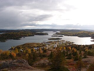
Little Bay is a town located in the Canadian province of Newfoundland and Labrador. Its current population is about 166 people. It is located in Green Bay, which is part of Notre Dame Bay, which is located in the central part of Newfoundland and Labrador. Some towns near Little Bay include Beachside, St Patrick's, Little Bay Islands, and the main center for Green Bay, Springdale.
Pilley's Island is a town located on the island of the same name in the Canadian province of Newfoundland and Labrador. It is located in Division No. 8, Newfoundland and Labrador.

Little Bay Islands is a vacant town in Newfoundland and Labrador, Canada. It consists of Little Bay Island, Macks Island, Goat Island, Harbour Island and Boatswain Tickle Island. The highest mount is 125-metre (410 ft) high Campbell Hill, which is located in Notre Dame Bay, near Springdale.

La Scie is a town in the Canadian province of Newfoundland and Labrador. The town had a population of 872 in the Canada 2016 Census, down from 899 in 2011.
Pacquet is a town in the Canadian province of Newfoundland and Labrador. The town had a population of 164 in 2016, down from 184 in the Canada 2011 Census.
Salvage is a town located on the Eastport Peninsula of the Canadian province of Newfoundland and Labrador. The town had a population of 124 in the Canada 2016 Census.
Lushes Bight–Beaumont–Beaumont North is a town on Long Island in Notre Dame Bay in the Canadian province of Newfoundland and Labrador. The town had a population of 168 at the 2016 Census, down from 275 in the 2006 Census.
William's Harbour is a local service district and designated place in the Canadian province of Newfoundland and Labrador. The community was entirely resettled in 2017.