
Potter Heigham is a village and civil parish on the River Thurne in the English county of Norfolk. It is situated 12 mi (19 km) north-east of the city of Norwich on the A149 road, and within the Broads.

Breckland is a local government district in Norfolk, England. Its council is based in Dereham. The district had a population of 130,491 at the 2011 Census.

All Saints and St Nicholas, South Elmham is a civil parish in the north of the English county of Suffolk. It is 5 miles (8.0 km) south of the market town of Bungay and the same distance north-west of Halesworth and east of Harleston. The parish is in the East Suffolk district and is one of the parishes that make up the area around Bungay known as The Saints. It includes the settlements of All Saints, South Elmham and St Nicholas, South Elmham.

Beachamwell is a village and civil parish in the Breckland district of Norfolk, England about 5 miles (8.0 km) south west of Swaffham and 10 miles (16 km) east of Downham Market. It has four ancient churches, two of them in ruins. The former parish of Shingham has been annexed.

Blundeston is a village and civil parish in the north of the English county of Suffolk. It is 3.5 miles (5.6 km) north-west of Lowestoft, 6 miles (9.7 km) south of Great Yarmouth and around 1.75 miles (2.82 km) inland from the North Sea coast. It is part of the area known as Lothingland in the East Suffolk district. Blundeston Prison was located on the southern edge of the village but closed in early 2014.

Ringstead is a village and civil parish in the north-west corner of the English county of Norfolk. It covers an area of 11.13 km2 (4.30 sq mi) and had a population of 355 in 155 households at the 2001 census, reducing to 324 at the 2011 Census. For the purposes of local government, it falls within the district of King's Lynn and West Norfolk.

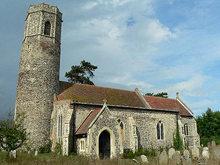
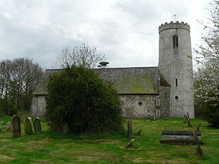
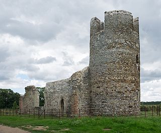
Round-tower churches are a type of church found mainly in England, mostly in East Anglia; of about 185 surviving examples in the country, 124 are in Norfolk, 38 in Suffolk, six in Essex, three in Sussex and two each in Cambridgeshire and Berkshire. There is evidence of about 20 round-tower churches in Germany, of similar design and construction to those in East Anglia. Countries with at least one round-tower church include Andorra, the Czech Republic, Denmark, France, Italy, Sweden, Norway, Poland and South Africa.
Mutford is a village and civil parish in the East Suffolk District of the English county of Suffolk. The village is 5 miles (8.0 km) south-west of Lowestoft and 4 miles (6.4 km) south-east of Beccles in a rural area. The parish borders Barnby, Carlton Colville, Gisleham, Rushmere, Henstead with Hulver Street, Ellough and North Cove. The village gave its name to the Half Hundred of Mutford which is named in the Domesday Book.

Gisleham is a village and civil parish in the English county of Suffolk. It is on the edge of Lowestoft, around 4.5 miles (7.2 km) south-west of the town centre. The parish is in the East Suffolk district, situated between Carlton Colville and Kessingland.
Ilketshall St Margaret is a village and civil parish in the north of the English county of Suffolk. It is 3 miles (4.8 km) south of the market town of Bungay in the East Suffolk district. The parish is part of the area known as the Saints and had a population of 160 at the 2011 United Kingdom census.

All Saints' South Elmham is a village and former civil parish in the north of the English county of Suffolk. The parish was combined with St Nicholas South Elmham in 1737 to form the parish of All Saints and St. Nicholas, South Elmham. It is 5 miles (8.0 km) south of the market town of Bungay in the East Suffolk district. It is one of the villages that make up the area around Bungay known as The Saints.

Mettingham is a village and civil parish in the north of the English county of Suffolk. It is 2 miles (3.2 km) east of the market town of Bungay in the East Suffolk district. It had a population of 211 at the 2011 United Kingdom census.

Pudding Norton is a village and civil parish in the English county of Norfolk. It covers an area of 2.30 sq mi (6.0 km2) and had a population of 267 in 126 households at the 2001 census, falling to 252 at the 2011 Census. For the purposes of local government, it falls within the district of North Norfolk.

Little Cressingham lies 2.5 miles (4.0 km) south east by road from Great Cressingham, 3 miles (4.8 km) west of Watton and 8 miles (13 km) south of Swaffham in the Breckland District of Norfolk. It covers an area of 11.90 km2 (4.59 sq mi) and had a population of 157 in 70 households at the 2001 census It is in the civil parish of Great Cressingham. The village is located on the edge of the Stanford Battle Area.
Flitcham with Appleton is a civil parish in the English county of Norfolk. It covers an area of 17.08 km2 (6.59 sq mi) and had a population of 236 in 96 households at the 2001 census. The population, including the parish of Anmer, was 276 at the 2011 Census.

St Margaret's Church is a round-tower church in Burnham Norton, Norfolk, England. Likely to have been built in the 11th century, the building retains many medieval architectural features, and is Grade I listed. It also retains an elaborately decorated 15th-century pulpit, considered one of the finest surviving examples of its type.
The Old Manor is a Grade II listed building, which stands in Pages Lane/Page's Place in the Norfolk village of Saham Toney. The building was owned by Edward Goffe of Threxton, who died in 1612, and who is buried at Saham Toney. He left the building to his son. Edward Goffe founded the local school, where a plaque was erected in his name. There are almshouses, founded by Edward Goffe. The beautiful stained glass window was made in Norwich Cathedral and originally came from St Marys church in Great Cressingham.

St Mary's Church is a round-tower church in Burnham Deepdale, Norfolk, England. Its round tower and some other parts of the building date from the 11th century. The church underwent additions and rebuilding in the medieval period. It fell into disrepair by the early 18th century, and much of the current building's appearance dates from an 1870 renovation by Frederick Preedy. The church is famed for its many 14th- and 15th-century medieval stained glass windows, and for its Norman font depicting the Labours of the Months.

St Peter's is one of seven churches in the parish of Upper Tas Valley All Saints in south Norfolk, ten miles south of Norwich, UK. The full name is St Peter's and St Paul's, commonly known as St Peter's, and was formerly the parish church for Forncett St Peter. It is an active place of worship and a nationally significant Grade I listed building. Its Anglo-Saxon round tower, built circa 1000 AD, is considered one of the best in the country. There are other Anglo-Saxon features. Much of the main building is of later, mainly 14th and 15th century date. Significant features are: the 1485 Drake tomb, a unique ancient staircase in the tower, carved pew ends, fine ledger slabs in the chancel and nave, good examples of Victorian coloured glass windows, and the ring of six bells. There is an excellent guide to the church. There is a connection with William Wordsworth: his sister, Dorothy, lived at the rectory from 1788 until 1794 with her uncle, the rector, William Cookson.
