Gallery
 Edwardian Terrace Houses - Thurlow Park Rd (South Circular)
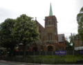 Rosemead Pre-Preparatory School, Formerly St. Cuthbert's Church
 All Saints Church, Rosendale Rd
 Rosendale Pubs, Former Victorian Coaching Inn
| Thurlow Park | |
|---|---|
| Former electoral ward for the Lambeth London Borough Council | |
| London borough | Lambeth |
| County | Greater London |
| Former electoral ward | |
| Created | 1965 |
| Abolished | 2022 |
| Member(s) | 3 |
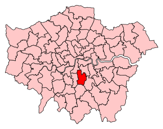
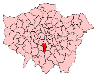
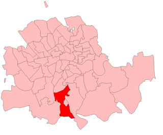
Thurlow Park ward was an administrative division of the London Borough of Lambeth, England from 1965 to 2022.
It was located in the constituency of Dulwich and West Norwood. [1]
It was located towards the south of the borough containing parts of Herne Hill, Tulse Hill (including the Tulse Hill railway station), and West Norwood. It was bordered in the north by Brockwell Park. The population of the ward at the 2011 Census was 13,641. [2]
Below are the demographics for Thurlow Park [3]
| Nbr | Percent | |
|---|---|---|
| Males | 6,966 | 49% |
| Females | 7,262 | 51% |
| Nbr | Percent | |
|---|---|---|
| 0–17 years | 3,401 | 23.9% |
| 18–64 years | 9,407 | 66.1% |
| 65+ years | 1,420 | 10% |
| Nbr | Percent | |
|---|---|---|
| White | 8,687 | 63.7% |
| Black | 2,773 | 20.3% |
| Asian | 804 | 5.9% |
| Mixed/multiple | 1,117 | 8.2% |
| Other | 260 | 1.7% |


| Party | Candidate | Votes | % | ±% | |
|---|---|---|---|---|---|
| Labour Co-op | Anna Birley* | 2,377 | |||
| Labour Co-op | Fred Cowell* | 2,308 | |||
| Labour Co-op | Peter Ely | 2,076 | |||
| Conservative | Kelly Ben-Maimon | 820 | |||
| Conservative | Elia Carvalho | 820 | |||
| Conservative | Jack Kelly | 761 | |||
| Liberal Democrats | Kathy Erasmus | 691 | |||
| Liberal Democrats | Doug Buist | 649 | |||
| Liberal Democrats | Bryan Mahon | 576 | |||
| Green | Alice Playle | 512 | |||
| Green | Danielle Montrose-Francis | 461 | |||
| Green | Dale Mathers | 458 | |||
| Independent | Robin Lambert | 89 | |||
| Labour hold | Swing | ||||
| Labour hold | Swing | ||||
| Labour hold | Swing | ||||
| Party | Candidate | Votes | % | ±% | |
|---|---|---|---|---|---|
| Labour | Anna Birley | 2,212 | |||
| Labour | Fred Cowell | 2,122 | |||
| Labour | Max Deckers Dowber | 2,031 | |||
| Conservative | Irene Kimm | 1,117 | |||
| Conservative | Luke Tryl | 1,097 | |||
| Conservative | Graham Pycock | 1,020 | |||
| Green | Matt Farrow | 673 | |||
| Green | Pat Price-Tomes | 544 | |||
| Green | Jo Stone-Fewings | 540 | |||
| Liberal Democrats | Andrew Thurburn | 279 | |||
| UKIP | Robin Lambert | 277 | |||
| Liberal Democrats | Malgorzata Baker | 259 | |||
| Liberal Democrats | Jeremy Baker | 254 | |||
| Total votes | 14,825 | ||||
| Labour gain from Conservative | Swing | ||||
| Labour hold | Swing | ||||
| Labour gain from Conservative | Swing | ||||
| Party | Candidate | Votes | % | ±% | |
|---|---|---|---|---|---|
| Conservative | John Whelan * | 2,452 | |||
| Labour | Ann Kingsbury | 2,035 | |||
| Conservative | Clare Whelan * | 2,023 | |||
| Labour | Robert Holden | 1,945 | |||
| Conservative | Irene Kimm * | 1,906 | |||
| Labour | Brian Cowie | 1,888 | |||
| Liberal Democrats | Richard Bramwell | 1,516 | |||
| Liberal Democrats | Dominic Carman | 1,447 | |||
| Liberal Democrats | Andrew Thurburn | 1,447 | |||
| Green | William Collins | 781 | |||
| Green | Samarajit Roy | 609 | |||
| Green | Dale Mathers | 595 | |||
| UKIP | Robin Lambert | 178 | |||
| Total votes | 18,656 | ||||
| Conservative hold | Swing | ||||
| Labour gain from Conservative | Swing | ||||
| Conservative hold | Swing | ||||
| Party | Candidate | Votes | % | ±% | |
|---|---|---|---|---|---|
| Conservative | Clare Whelan * | 1,738 | |||
| Conservative | John Whelan * | 1,680 | |||
| Conservative | Irene Kimm * | 1,460 | |||
| Labour | Sharon Erdman | 762 | |||
| Green | Sheila Freeman | 699 | |||
| Labour | Matthew Parr | 667 | |||
| Liberal Democrats | Alan Beadnall | 593 | |||
| Labour | Paul Teverson | 558 | |||
| Liberal Democrats | Anton Baker | 486 | |||
| Liberal Democrats | Andrew Thurburn | 420 | |||
| Local Education Action by Parents | Stela Gildea | 350 | |||
| UKIP | Robin Lambert | 112 | |||
| Total votes | 9,525 | ||||
| Conservative hold | Swing | ||||
| Conservative hold | Swing | ||||
| Conservative hold | Swing | ||||
| Party | Candidate | Votes | % | ±% | |
|---|---|---|---|---|---|
| Conservative | Clare Whelan * | 1,484 | |||
| Conservative | John Whelan * | 1,437 | |||
| Conservative | Irene Kimm * | 1,308 | |||
| Labour | Judith Brodie | 684 | |||
| Labour | David Rodgers | 583 | |||
| Labour | Alan Wilmot | 551 | |||
| Liberal Democrats | Alan Beadnall | 466 | |||
| Liberal Democrats | Andrew Thurburn | 336 | |||
| Green | Jeremy Hicks | 329 | |||
| Liberal Democrats | Duncan Brack | 319 | |||
| UKIP | Robin Lambert | 53 | |||
| Turnout | 7,550 | 29.6 | |||
| Conservative hold | Swing | ||||
| Conservative hold | Swing | ||||
| Conservative hold | Swing | ||||
| | This section is empty. You can help by adding to it. (October 2023) |
| | This section is empty. You can help by adding to it. (October 2023) |
| | This section is empty. You can help by adding to it. (October 2023) |
| | This section is empty. You can help by adding to it. (October 2023) |
| | This section is empty. You can help by adding to it. (October 2023) |
| | This section is empty. You can help by adding to it. (October 2023) |
| | This section is empty. You can help by adding to it. (October 2023) |
| | This section is empty. You can help by adding to it. (October 2023) |
| | This section is empty. You can help by adding to it. (October 2023) |
| | This section is empty. You can help by adding to it. (October 2023) |

Tulse Hill is a district in the London Borough of Lambeth in South London that sits on Brockwell Park. It is approximately five miles from Charing Cross and is bordered by Brixton, Dulwich, Herne Hill, Streatham and West Norwood.

Lambeth is a London borough in South London, England, which forms part of Inner London. Its name was recorded in 1062 as Lambehitha and in 1255 as Lambeth. The geographical centre of London is at Frazier Street near Lambeth North tube station, though nearby Charing Cross on the other side of the Thames in the City of Westminster is traditionally considered the centre of London.

West Norwood is a largely residential area of south London within the London Borough of Lambeth, located 5.4 miles (8.7 km) south south-east of Charing Cross. The centre of West Norwood sits in a bowl surrounded by hillsides on its east, west and south sides. From many parts of the area, distant views can be seen, of places such as the City of London, Canary Wharf and Crystal Palace.

Camberwell was a civil parish and metropolitan borough in south London, England. Camberwell was an ancient parish in the county of Surrey, governed by an administrative vestry from 1674. The parish was included in the area of responsibility of the Metropolitan Board of Works in 1855 and became part of the County of London in 1889. The parish of Camberwell became a metropolitan borough in 1900, following the London Government Act 1899, with the parish vestry replaced by a borough council. In 1965 the borough was abolished and its former area became part of the London Borough of Southwark in Greater London.

Lambeth was a civil parish and metropolitan borough in south London, England. It was an ancient parish in the county of Surrey. The parish was included in the area of responsibility of the Metropolitan Board of Works in 1855 and became part of the County of London in 1889. The parish of Lambeth became a metropolitan borough in 1900, following the London Government Act 1899, with the parish vestry replaced by a borough council.
Dulwich and West Norwood is a constituency in South London created in 1997. It has been represented by Helen Hayes of Labour since her election in 2015.
Streatham is a constituency represented in the House of Commons of the UK Parliament since 2019 by Bell Ribeiro-Addy of the Labour Party.

Gipsy Hill in south London is a hilly and leafy neighbourhood spanning the southern parts of the London Boroughs of Lambeth and Southwark characterised for its stunning views of the City of London and Dulwich.
Norwood was a parliamentary constituency in south London which returned one Member of Parliament (MP) to the House of Commons of the Parliament of the United Kingdom by the first past the post system.

West Dulwich is a neighbourhood in South London on the southern boundary of Brockwell Park, which straddles the London Borough of Lambeth and the London Borough of Southwark. Croxted Road and South Croxted Road mark the boundary between Southwark to the east and Lambeth to the west. The suburb of West Dulwich dates back to the 17th century when the often flooded land known as Dulwich Common was acquired and drained by Edward Alleyn's estate.

The Norwood Ridge is a 10-square-mile (26 km2) rectangular upland which occupies the geographical centre of south London, centred 5 miles (8 km) south of London Bridge. Beneath its topsoil it is a ridge of London Clay that is capped on all sides with remaining natural gravel deposits mixed with some sandy soil, which in the South Thames basin is a material known as the Claygate Beds.

The A2199 is an urban A-road in south London. It runs from the A215 Norwood Road, in the centre of Herne Hill, to the A212 Crystal Palace Parade.

All Saints' Church is a Church of England parish church in West Dulwich, South London. It is a red brick building designed in a Gothic Revival style by George Fellowes Prynne and built 1888–91. It is Grade I listed.
Herne Hill was an administrative division of the London Borough of Lambeth, England from 1965 to 2022. It was located in Herne Hill and contained Brockwell Park, Ruskin Park and Herne Hill railway station. Loughborough Junction railway station and King's College Hospital were also partially located within the ward. At the 2011 Census the population of the ward was 15,107.
Tulse Hill ward was an administrative division of the London Borough of Lambeth, England from 1965 to 2022.
Streatham Hill ward was an administrative division of the London Borough of Lambeth, United Kingdom from 1978 to 2022. It included the neighbourhoods in the northern part of Streatham either side of the road of the same name.
Knight's Hill ward is an administrative division of the London Borough of Lambeth, United Kingdom, roughly covering the West Norwood area.
Gipsy Hill ward is an administrative division of the London Borough of Lambeth, England.

Knight's Hill is a hill in the Tulse Hill and West Dulwich area of the London Borough of Lambeth.