
Thiruvaiyaru is a panchayat town in Thanjavur District in the Indian state of Tamil Nadu.

Ariyalur district is an administrative district, one of the 38 districts in the state of Tamil Nadu in India. The district headquarters is located at Ariyalur. The district encompasses an area of 1,949.31 km².
Kizhakkancherry is a gram panchayat in the Palakkad district, state of Kerala, India. It is a local government organisation that serves the villages of Kizhakkencheri-I and Kizhakkencheri-II. It was formed in the year of 1951 and is the fourth largest grama panchayath in Kerala. It covers an area of 112.56 km2 and comprises 22 wards. The boundaries are Vadakkencherry (north), Pananjeri (south), Vandazhy (east) and Kannambra (west). The village is located 37.4 km from the city of Palakkad and 34.9 km from Thrissur.

Tiruchirappalli District is one of the 38 districts, located along the Kaveri River, in Tamil Nadu, India. The headquarters of the district is the city of Tiruchirappalli.

Jayankondam is a First Grade Municipality in Ariyalur district of Tamil Nadu in India. As of 2023, the town had a population of 46,000.

Lalgudi is a town in Tiruchirapalli district in the Indian state of Tamil Nadu. The town of Lalgudi heads the Lalgudi taluk, Lalgudi division, Lalgudi Educational District, Lalgudi DSP and Lalgudi Constituency.

Udayarpalayam is a panchayat town in the Ariyalur district of the Indian state of Tamil Nadu, near Jayankondam.

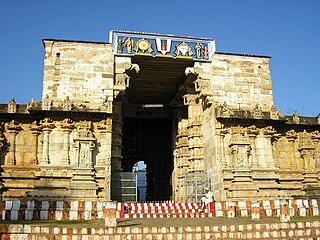
Ariyalur is a town and district headquarters of Ariyalur district in the South Indian state of Tamil Nadu and is rich in limestone, surrounded with seven cement factories and two sugar factories. The town is located at a distance of 310 km (190 mi) from the state capital Chennai.
Thirukkurungudi is a town which is located in Tirunelveli district, Tamil Nadu, South India. Thirukkurungudi is part of Nanguneri taluk and is part of the Tamil Nadu legislative assembly constituency of Nanguneri. At the foothills of the Western Ghats and 40 km to the North of Kanyakumari and about 120 km from Thiruvananthapuram the capital city of Kerala, Thirukkurungudi is a village with history dating back more than 1500 years. Village life revolves around agriculture and the Nambi Rayar temple. It is one of the 108 Divya Desams, Hindu temples that are sacred for the Vaishnavas.
Periapalayam is a village about 40 km north of Chennai, in Tiruvallur district, Tamil Nadu State, India. The nearest Railway station is Thiruninravur.It is in Ellapuram block which stretches from east Thanakulam village, west Uthukottai, north Kosavanpettai and in the south up to Komakambedu village. It has one of the main routes to Andhra Pradesh.

Thanjavur district is one of the 38 districts of the state of Tamil Nadu, in southeastern India. Its headquarters is Thanjavur. The district is located in the delta of the Cauvery River and is mostly agrarian.
Unjalur is a panchayat town situated in Erode district in the Indian state of Tamil Nadu. Unjalur is located about 32 kilometres (20 mi) from district headquarters Erode and 8 kilometres (5.0 mi) from Kodumudi, which is known for the Mahudeswarar, Veera Narayana Perumal and Brama Deva temple.
Devanancheri is a village in the Kumbakonam taluk of Thanjavur district, Tamil Nadu. It is located 42 km north of the district headquarters in Thanjavur, 8 km from Kumbakonam, and 286 km from the state capital, Chennai. The local language is Tamil.

Pudukkottai is a village in the Ariyalur taluk of Ariyalur district, Tamil Nadu, India. The village has a population of 1856 in 2001 making it smallest settlement in Ariyalur. The Village is close to the Tiruchirapplli District and Thanjavur District border and is within a short distance of locations such as Tiruchirappalli, the Ariyalur and Thanjavur.
Siruvalur is a village in Ariyalur district, Tamil Nadu, India. The village has its own government high school which it is planning to upgrade to a higher secondary school. Siruvalur is located at 1 km from National Highway 227 (India) Tiruchirapalli to Chidambaram. Siruvalur is 12 km from district headquarters Ariyalur.
Sannasinallur is a village in Sendurai Taluk of Ariyalur District, Tamil Nadu, India. Located on the southern bank of the Vellar River bordering Caddalore District. Once part of Trichy District and now in Ariyalur District. People here are highly literate. Many are qualified engineers,doctors,IAS and IPS Officers and many work overseas, mainly in Singapore and Middle east Countries. There is a post office and a high school teaching up to 10th standard. There are quite a few temples and is well known for Pacchai Amman Temple and Semmalaiappar Temple. And just across the river, is the famous Thiruvatta Thurai(also known as Thirunelvoyel Arathurai) Sivan temple. There are two cement factories nearby and is well connected by road and rail with the rest of the state. Trichy international airport is just 70 km away.
Andimadam is a town in Tamil Nadu. It is one of the blocks in the Ariyalur district and Taluk in the Ariyalur district "Land Of Cement", Tamil Nadu, India. It has three State Highways running across.
Mannankadu is a village in the Pattukkottai taluk of Thanjavur district, Tamil Nadu, India. It is one of the 42 villages falls under the Musugundan Nadu in the district. Mannangadu is one of the revenue village in its taluk. It is located on state highway Adirampattinam-Mannargudi-Kumbakonam, between Adirampattinam and Madukkur. It is the fourth largest village in Pattukkottai taluk, after Thamarankottai, Thambikottai and Aalathur. Total geographical area of the Village is 740.20 hectares.veerakodi vellalars and ambalakarars are the highest population living in mannangadu. Mannangadu is also a part of musukundan nadu. In early years mannangadu was split into two mannangadu south and mannangadu north. In early period Mannangadu were mainly occupied by iyer and kallars.melakadu were belongs to iyers and it was called agraharam. kelakadu were fully occupied by kallars Later, the lands were owned by silambayi veedu, palaniyam veedu, sevidi veedu, vairaya veedu, pancham veedu, aachi veedu, are emigrated from various surrounding villages. Among all these are neighbourhoods and landlords. They belongs to different temples such as nallakathayi amman, adaikalamkathar, kuttapili kovil,and having different ponds like koluppan kulam, pulacha odai, pani kundu, puthukulam. The main income from this village is coconut and paddy cultivation. In each and every family one person will working in foreign countries.so, the main income is comes from abroad.
Rajamadam is a coastal village in the Pattukkottai taluk of Thanjavur district, Tamil Nadu, India. Rajamadam to Adirampattinam is 6 km from its Taluk Main Town, Pattukkottai, 15 km. Rajamadam is 58.1 km distant from its District Main City Thanjavur and 320 km distance from its State Main City Chennai. It is the birthplace of the former President of India and an independence activist R. Venkitaraman.
Anaikarai is a village panchayat under Thiruvidaimarudur Taluk in Tanjavur district, Tamil Nadu, India. Anaikarai connects with two major bridges. Nearly 1 km long on both sides. It is an island in the basin of Cauvery river. It is located at the distance of 260 km from Chennai and 25 km from Kumbakonam.