Tong is a boma in Baidit payam, Bor West County, Jonglei State, South Sudan, about 30 kilometers north of Bor. The village is located at the southern extent of the sudd, South Sudan's central wetlands, near to the east bank of the Bahr al Jabal River.
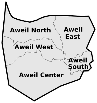
Aweil East County is a county in South Sudan.
Baidit is a Payam in Bor West County, in Jonglei State, South Sudan. It is situated on the east side of the Bahr al Jabal River a short distance north of Bor, South Sudan. Baidit is the county headquarters for Bor West County.
Mathiang is a boma in Baidit payam, Bor West County, Jonglei State, South Sudan, about 30 kilometers north of Bor. The village is located at the southern extent of the sudd, South Sudan's central wetlands, on the east side of the Bahr al Jabal River.
Mayen is a boma in Baidit payam, Bor West County, Jonglei State, South Sudan, about 30 kilometers north of Bor. The village is located at the southern extent of the sudd, South Sudan's central wetlands, near to the east bank of the Bahr al Jabal River.
Akayiech is a boma in Baidit payam, Bor West County, Jonglei State, South Sudan, about 30 kilometers north of Bor. The village is located at the southern extent of the sudd, South Sudan's central wetlands, near to the east bank of the Bahr al Jabal River.
Thianwei is a boma in Anyidi payam, Bor East County, Jonglei State, South Sudan, about 25 kilometers east of Bor and 5 kilometers from Anyidi village, the administrative center of Anyidi payam.
Mareng is a boma in Anyidi payam, Bor East County, Jonglei State, South Sudan, about 25 kilometers east of Bor.
Chuei Magon is a boma in Anyidi payam, Bor East County, Jonglei State, South Sudan, about 25 kilometers east of Bor.
Makuach is a Payam in Bor Central County, in Jonglei State, South Sudan. It is situated on the east side of the Bahr al Jabal River. Bor town borders Makuach to the west, Baidit Payam to the north, and Anyidi Payam to the south.
Kapat is a boma in Makuach payam, Bor Central County, Jonglei State, South Sudan, about 10 kilometers east of Bor.
Makuach village is a boma in Makuach payam, Bor Central County, Jonglei State, South Sudan, about 15 kilometers east of Bor.
Jalle is a Payam in Bor North County, in Jonglei State, South Sudan. It is situated on the east side of the Bahr al Jabal River between Bor and Twic East.
Akuai-deng is a boma in Jalle payam, Bor North County, Jonglei State, South Sudan, about 45 kilometers northeast of Bor. The village borders Baidit Payam and is located at the southern extent of the sudd, South Sudan's central wetlands, near to the east bank of the Bahr al Jabal River.
Pariak is a boma in Kolnyang payam, Bor South County, Jonglei State, South Sudan. Pariak town is a regional trading hub located about 30 kilometers south of Bor along the Bor-Juba road. It is the most populous boma in Kolnyang payam.
Kolnyang is a boma in Kolnyang payam, Bor South County, Jonglei State, South Sudan.
Tiar Aliet is a payam in Aweil South County, in Northern Bahr el Ghazal State, South Sudan. It's the first most populous Town in Boncuai Community followed by Panthou
Mangar Lual is a boma in Tiar-aleit Payam, Ajak County, Northern Bahr el Ghazal, South Sudan.
Lankien is a boma in Thol Payam, Nyirol County, Jonglei State, South Sudan.
Aweil South County, sometimes called Paliet, is an administrative area in Northern Bahr el Ghazal, South Sudan bordering Warrap State to the south. It is located in the south eastern part of NBGs. It is also known by the name Paliet, and one of the counties consisting of three major Dinka tribal groups of Ajak, Boncuai and Kongdeer. It was founded in 2000, headquartered in Boncuai in a place called Mangar-Gier. In 2004, the headquarters were shifted to Malek Alel in Ajak. It is boardered to the north by Aweil East and to the west by Aweil Centre, to the south east by Gogrial State, and to the southwest by Western Barh el Ghazal state respectively.
