
The Lower Mainland is a geographic and cultural region of the mainland coast of British Columbia that generally comprises the regional districts of Metro Vancouver and the Fraser Valley. Home to approximately 3.05 million people as of the 2021 Canadian census, the Lower Mainland contains sixteen of the province's 30 most populous municipalities and approximately 60% of the province's total population.

The Potomac River is a major river in the Mid-Atlantic region of the United States that flows from the Potomac Highlands in West Virginia to the Chesapeake Bay in Maryland. It is 405 miles (652 km) long, with a drainage area of 14,700 square miles (38,000 km2), and is the fourth-largest river along the East Coast of the United States. More than 6 million people live within its watershed.

The Susquehanna River is a major river located in the Mid-Atlantic region of the United States, crossing three lower Northeast states. At 444 miles (715 km) long, it is the longest river on the East Coast of the United States. By watershed area, it is the 16th-largest river in the United States, and also the longest river in the early 21st-century continental United States without commercial boat traffic.

Union Bay is a body of water located in Seattle, Washington. Part of Lake Washington, it is bounded by the Laurelhurst neighborhood to the north and the Montlake and Madison Park neighborhoods to the south. The Evergreen Point Floating Bridge, which carries State Route 520, crosses over a portion of the bay.

The Anacostia River is a river in the Mid Atlantic region of the United States. It flows from Prince George's County in Maryland into Washington, D.C., where it joins with the Washington Channel and ultimately empties into the Potomac River at Buzzard Point. It is about 8.7 miles (14.0 km) long. The name "Anacostia" derives from the area's early history as Nacotchtank, a settlement of Necostan or Anacostan Native Americans on the banks of the Anacostia River.
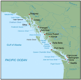
The Inside Passage is a coastal route for ships and boats along a network of passages which weave through the islands on the Pacific Northwest coast of the North American Fjordland. The route extends from southeastern Alaska in the United States, through western British Columbia in Canada, to northwestern Washington state in the United States. Ships using the route can avoid some of the bad weather in the open ocean and may visit some of the many isolated communities along the route. The Inside Passage is heavily travelled by cruise ships, freighters, tugs with tows, fishing craft, pleasure craft, and ships of the Alaska Marine Highway, BC Ferries, and Washington State Ferries systems. Coast Guard vessels of both Canada and the United States patrol and transit in the Passage.

Swampoodle was a neighborhood in Washington, D.C. on the border of Northwest and Northeast in the second half of 19th and early 20th century. This neighborhood is no longer known as Swampoodle and has been replaced in large part by NoMa.

Constitution Avenue is a major east–west street in the northwest and northeast quadrants of the city of Washington, D.C., in the United States. It was originally known as B Street, and its western section was greatly lengthened and widened between 1925 and 1933. It received its current name on February 26, 1931, though it was almost named Jefferson Avenue in honor of Thomas Jefferson.

The history of Washington, D.C., is tied to its role as the capital of the United States. The site of the District of Columbia along the Potomac River was first selected by President George Washington. The city came under attack during the War of 1812 in an episode known as the Burning of Washington. Upon the government's return to the capital, it had to manage the reconstruction of numerous public buildings, including the White House and the United States Capitol. The McMillan Plan of 1901 helped restore and beautify the downtown core area, including establishing the National Mall, along with numerous monuments and museums.
Bloomingdale is a neighborhood in the Northwest quadrant of Washington, D.C., less than two miles (3 km) north of the United States Capitol building. It is a primarily residential neighborhood, with a small commercial center near the intersection of Rhode Island Avenue and First Street NW featuring bars, restaurants, and food markets.

Portus was a large artificial harbour of Ancient Rome located at the mouth of the Tiber on the Tyrrhenian Sea. It was established by Claudius and enlarged by Trajan to supplement the nearby port of Ostia.

Tiber Creek or Tyber Creek, originally named Goose Creek, is a tributary of the Potomac River in Washington, D.C. It was a free-flowing creek until 1815, when it was channeled to become part of the Washington City Canal. Presently, it flows under the city in tunnels, including under Constitution Avenue NW.
The Washington City Canal was a canal in Washington, D.C., that operated from 1815 until the mid-1850s. The canal connected the Anacostia River, termed the "Eastern Branch" at that time, to Tiber Creek, the Potomac River, and later the Chesapeake and Ohio (C&O) Canal. The canal fell into disuse during the late 19th century and the city government covered over or filled in various sections in 1871.

Goose Creek is a 53.9-mile-long (86.7 km) tributary of the Potomac River in Fauquier and Loudoun Counties in Northern Virginia. It comprises the principal drainage system for the Loudoun Valley.
The Southwest Waterfront is a neighborhood in Southwest Washington, D.C. The Southwest quadrant is the smallest of Washington's four quadrants, and the Southwest Waterfront is one of only two residential neighborhoods in the quadrant; the other is Bellevue, which, being east of the Anacostia River, is frequently, if mistakenly, regarded as being in Southeast.

Tiber Island Cooperative Homes is a housing complex in the Southwest portion of Washington DC. The 378 apartments in four nine-story towers and 21 townhouses were built in 1965 as part of a planned redevelopment of the area. The site was listed on the National Register of Historic Places in 2013 and contains the Thomas Law House, which is also listed.

James Creek was a tributary of the Anacostia River in the southwest quadrant of Washington, D.C., once known as St. James' Creek and perhaps named after local landowner James Greenleaf.

People of Irish descent form a distinct ethnic group in Washington, D.C., and have had a presence in the region since the pre-American Revolution period.

