
An estuary is a partially enclosed coastal body of brackish water with one or more rivers or streams flowing into it, and with a free connection to the open sea. Estuaries form a transition zone between river environments and maritime environments and are an example of an ecotone. Estuaries are subject both to marine influences such as tides, waves, and the influx of saline water and to fluvial influences such as flows of freshwater and sediment. The mixing of seawater and freshwater provides high levels of nutrients both in the water column and in sediment, making estuaries among the most productive natural habitats in the world.

A river delta is a landform created by deposition of sediment that is carried by a river as the flow leaves its mouth and enters slower-moving or stagnant water. This occurs where a river enters an ocean, sea, estuary, lake, reservoir, or another river that cannot carry away the supplied sediment. The size and shape of a delta is controlled by the balance between watershed processes that supply sediment, and receiving basin processes that redistribute, sequester, and export that sediment. The size, geometry, and location of the receiving basin also plays an important role in delta evolution.

A salt marsh or saltmarsh, also known as a coastal salt marsh or a tidal marsh, is a coastal ecosystem in the upper coastal intertidal zone between land and open saltwater or brackish water that is regularly flooded by the tides. It is dominated by dense stands of salt-tolerant plants such as herbs, grasses, or low shrubs. These plants are terrestrial in origin and are essential to the stability of the salt marsh in trapping and binding sediments. Salt marshes play a large role in the aquatic food web and the delivery of nutrients to coastal waters. They also support terrestrial animals and provide coastal protection.

An inlet is an indentation of a shoreline, usually long and narrow, such as a small bay or arm, that often leads to an enclosed body of salt water, such as a sound, bay, lagoon, or marsh.

Tuggerah Lake, an intermittently open intermediate wave dominated barrier estuary that is part of the Tuggerah Lakes, is located within the Central Coast Council local government area in the Central Coast region of New South Wales, Australia. The lake is located near Wyong and is situated about 90 kilometres (56 mi) north of Sydney.

A tidal creek or tidal channel is a narrow inlet or estuary that is affected by ebb and flow of ocean tides. Thus it has variable salinity and electrical conductivity over the tidal cycle, and flushes salts from inland soils. Tidal creeks are characterized by slow water velocity resulting in buildup of fine, organic sediment in wetlands. Creeks may often be a dry to muddy channel with little or no flow at low tide, but with significant depth of water at high tide. Due to the temporal variability of water quality parameters within the tidally influenced zone, there are unique biota associated with tidal creeks which are often specialised to such zones. Nutrients and organic matter are delivered downstream to habitats normally lacking these, while the creeks also provide access to inland habitat for salt-water organisms.

An artificial whitewater course (AWWC) is a site for whitewater canoeing, whitewater kayaking, whitewater racing, whitewater rafting, playboating and slalom canoeing with artificially generated rapids.

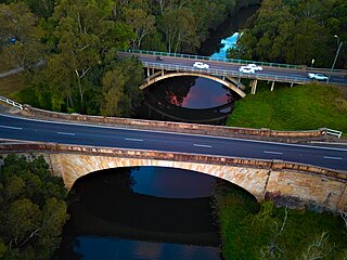
The Cooks River, a semi-mature tide dominated drowned valley estuary, is a tributary of Botany Bay, located in south-eastern Sydney, New South Wales, Australia.

The Lower Suwannee National Wildlife Refuge (LSNWR) is part of the United States National Wildlife Refuge System. It is located in southeastern Dixie and northwestern Levy counties on the western coast of Florida, approximately fifty miles southwest of the city of Gainesville.

Mattawoman Creek is a 30.0-mile-long (48.3 km) coastal-plain tributary to the tidal Potomac River with a mouth at Indian Head, Maryland, 20 miles (32 km) downstream of Washington, D.C. It comprises a 23-mile (37 km) river flowing through Prince George's and Charles counties and a 7-mile (11 km) tidal-freshwater estuary in Charles County. About three-fourths of its 94-square-mile (240 km2) watershed lies in Charles County, with the remainder in Prince George's County immediately to the north.

A tunnel valley is a U-shaped valley originally cut under the glacial ice near the margin of continental ice sheets such as that now covering Antarctica and formerly covering portions of all continents during past glacial ages. They can be as long as 100 km (62 mi), 4 km (2.5 mi) wide, and 400 m (1,300 ft) deep.

Aike Beck or the Lockington Navigation was a stream in the East Riding of Yorkshire, England, which was constructed as a navigation in the late 18th century, and ceased to function as such in the 1850s. The water supply came from Bryan Mills Beck and Scorborough Beck, but in 1988, these were diverted to feed into Arram Beck, and most of the channel was filled in with material from the flood banks.
A tidal river is a river whose flow and level are influenced by tides. A section of a larger river affected by the tides is a tidal reach, but it may sometimes be considered a tidal river if it has been given a separate name.

Lacamas Creek is in Clark County, Washington, United States, and flows about 12.5 miles (20.1 km) from headwaters near Camp Bonneville to Lacamas Lake and Round Lake in Camas, and eventually into the Washougal River. Its name is derived from that of the native camas plant. Lacamas Creek is fed by numerous streams, but the five largest tributaries are Matney Creek, Shanghai Creek, Fifth Plain Creek, China Ditch, and Dwyer Creek.

Iron Cove Creek, a southern tributary of the Parramatta River, is an urban stream west of Sydney Harbour, located in the inner-western Sydney suburbs of Croydon, Ashfield, Haberfield and Five Dock in New South Wales, Australia.

A stream is a continuous body of surface water flowing within the bed and banks of a channel. Depending on its location or certain characteristics, a stream may be referred to by a variety of local or regional names. Long large streams are usually called rivers, while smaller, less voluminous and more intermittent streams are known as streamlets, brooks or creeks, etc.

A river is a natural flowing watercourse, usually freshwater, flowing towards an ocean, sea, lake or another river. In some cases, a river flows into the ground and becomes dry at the end of its course without reaching another body of water. Small rivers can be referred to using names such as stream, creek, brook, rivulet, and rill. There are no official definitions for the generic term river as applied to geographic features, although in some countries or communities a stream is defined by its size. Many names for small rivers are specific to geographic location; examples are "run" in some parts of the United States, "burn" in Scotland and northeast England, and "beck" in northern England. Sometimes a river is defined as being larger than a creek, but not always: the language is vague.

Sullivans Creek, a partly perennial stream of the Murrumbidgee catchment within the Murray-Darling basin, is located in Canberra, Australian Capital Territory, Australia.
Estuaries of Australia are features of the Australian coastline. They are linked to tides, river mouths and coastal features and conditions. In many cases the features of estuaries are also named inlets.
The Lennox River is the proposed name for a waterway located in Sydney's South-Western Suburbs. The existing waterway is the tidal reach of Prospect Creek, a tributary of the Georges River. A proposal has been made to upgrade and reclassify the waterway as a 'river'. The proposed river would be 6.5 kilometres long, starting at the confluence of Orphan School Creek and Prospect Creek at Fairfield and flowing to the Georges River emptying into Dhurawal Bay at Garrison Point.