Tidone

Last updated
Tidone
Tidone.JPG
Location
Country Italy
Physical characteristics
Source 
  locationnear Monte Penice, Ligurian Apennines
  coordinates 44°48′18″N9°19′16″E / 44.805°N 9.321°E / 44.805; 9.321
  elevation1,000 m (3,300 ft)
Mouth  
  location
Po River near Sarmato and Rottofreno
  coordinates
45°04′44″N9°31′52″E / 45.0789°N 9.5312°E / 45.0789; 9.5312
Length47 km (29 mi) [1]
Discharge 
  average8 m3/s (280 cu ft/s) [2]
Basin features
Progression PoAdriatic Sea

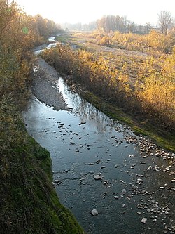
The Tidone is a river in the Region of Emilia Romagna in northern Italy. It is a right-bank tributary of the Po River. The stream rises in the Apennine Mountains near Monte Penice and flows in a northerly direction into the Po.

Contents

Geography

The Tidone's sources are on the northern slope of Monte Penice at an altitude of over 1,000 metres (3,281 ft) in the Apennine Mountains in the municipality of Menconico. The river flows down a narrow mountain valley called Val Tidone. The upper reaches of the stream are located in the Province of Pavia while the middle and lower course is in the Province of Piacenza. The village of Romagnese is found in the upper part of the valley.

Near the town of Nibbiano the Tidone flows into the Lago di Trebecco which is formed by a dam built in the 1920s. The reservoir is used for irrigation and the dam produces a modest amount of electricity.

The Tidone leaves the foothills near Pianello Val Tidone and enters the flat Po plains. The stream flows into the Po west of Piacenza between the towns of Sarmato on the west and Rottofreno on the east. The affluents of the Tidone are mountain streams called the Morcione, Tidoncello, Chiarone and Luretta. The Trebbia River is the next major river to the east.

History

The Battle of Trebbia was fought near the lower course of the Tidone when Hannibal defeated a Roman army in 218 BC. The name dates from the battle when a Roman centurion found the Tidone's waters to be clear and drinkable while the nearby Trebbia supposedly ran red with the blood of the battle's victims. In thanks to the river, the officer said O Valle ti dono questo anello; ti dono (I give). Also fought in the area was a second Battle of Trebbia in 1799 which pitted a Republican French army against Alexander Suvorov's allied armies of the Russian Empire and Habsburg Austria.

Tidone river map in the 18th century Fiume Tidone 1750.jpg
Tidone river map in the 18th century

Related Research Articles

<span class="mw-page-title-main">Ticino (river)</span> Tributary of the Po river

The river Ticino is the most important perennial left-bank tributary of the Po. It has given its name to the Swiss canton through which its upper portion flows.

<span class="mw-page-title-main">Battle of Trebbia (1799)</span> 1799 Battle during the War of the Second Coalition

The Battle of (the) Trebbia was fought near the rivers of Tidone, Trebbia, and Nure in northern Italy between the joint Russian and Habsburg army under Alexander Suvorov and the Republican French army of Étienne-Jacques-Joseph-Alexandre Macdonald. Though the opposing armies were approximately equal in total numbers, the Austro-Russians severely defeated the French, sustaining about 5,500 casualties while inflicting losses of 16,500 on their enemies. The War of the Second Coalition engagement occurred west of Piacenza, a city located 70 kilometres (43 mi) southeast of Milan.

<span class="mw-page-title-main">Apennine Mountains</span> Mountain ranges stretching the length of Italy

The Apennines or Apennine Mountains are a mountain range consisting of parallel smaller chains extending c. 1,200 km (750 mi) along the length of peninsular Italy. In the northwest they join with the Ligurian Alps at Altare. In the southwest they end at Reggio di Calabria, the coastal city at the tip of the peninsula. Since 2000 the Environment Ministry of Italy, following the recommendations of the Apennines Park of Europe Project, has been defining the Apennines System to include the mountains of north Sicily, for a total distance of 1,500 kilometres (930 mi). The system forms an arc enclosing the east side of the Ligurian and Tyrrhenian Seas.

<span class="mw-page-title-main">Piacenza</span> Comune in Emilia-Romagna, Italy

Piacenza is a city and comune in the Emilia-Romagna region of northern Italy, and the capital of the eponymous province. As of 2022, Piacenza is the ninth largest city in the region by population, with more than 102,000 inhabitants.

<span class="mw-page-title-main">Nure</span> River in Italy

The Nure is a small river in northern Italy. It has its source on the northern slopes of Mt. Nero, elevation 1,754 metres (5,755 ft) above sea level, and after a course of about 75 kilometres (47 mi)—the second longest of the province—flows into the Po River 10 kilometres (6 mi) east of Piacenza, in the vicinity of Roncarolo, a frazione of the commune of Caorso, on the border with the Lombard commune of Caselle Landi.

<span class="mw-page-title-main">Bobbio</span> Comune in Emilia-Romagna, Italy

Bobbio is a small town and comune in the province of Piacenza in Emilia-Romagna, northern Italy. It is located in the Trebbia River valley southwest of the town Piacenza. There is also an abbey and a diocese of the same name. Bobbio is the administrative center of the Unione Montana Valli Trebbia e Luretta. It is a member of the I Borghi più belli d'Italia association.

<span class="mw-page-title-main">Trebbia</span> River in Italy

The Trebbia is a river predominantly of Liguria and Emilia Romagna in northern Italy. It is one of the four main right-bank tributaries of the river Po, the other three being the Tanaro, the Secchia and the Panaro.

<i>Via Aemilia</i> Roman road in northern Italy; connected Rimini to Piacenza in 187 BC

The Via Aemilia was a trunk Roman road in the north Italian plain, running from Ariminum (Rimini), on the Adriatic coast, to Placentia (Piacenza) on the river Padus (Po). It was completed in 187 BC. The Via Aemilia connected at Rimini with the Via Flaminia, which had been completed 33 years earlier, to Rome.

<span class="mw-page-title-main">Tanaro</span> Italian river

The Tanaro, is a 276-kilometre (171 mi) long river in northwestern Italy. The river begins in the Ligurian Alps, near the border with France, and is the most significant right-side tributary to the Po in terms of length, size of drainage basin, and discharge.

<span class="mw-page-title-main">Arda (Italy)</span> River in Italy

The Arda is a torrent of Emilia-Romagna, Italy, nearly all of its course being within the province of Piacenza. It is a right tributary of the Po River.

<span class="mw-page-title-main">Sarmato</span> Comune in Emilia-Romagna, Italy

Sarmato is a comune (municipality) in the Province of Piacenza in the Italian region Emilia-Romagna, located about 160 kilometres (99 mi) northwest of Bologna and about 15 kilometres (9 mi) west of Piacenza. As of 31 December 2004, it had a population of 2,714 and an area of 27.0 square kilometres (10.4 sq mi). Sarmato borders the following municipalities: Borgonovo Val Tidone, Castel San Giovanni, Monticelli Pavese, Pieve Porto Morone, Rottofreno.

<span class="mw-page-title-main">Po Valley</span> Plain in Northern Italy

The Po Valley, Po Plain, Plain of the Po, or Padan Plain is a major geographical feature of Northern Italy. It extends approximately 650 km (400 mi) in an east-west direction, with an area of 46,000 km2 including its Venetic extension not actually related to the Po river basin; it runs from the Western Alps to the Adriatic Sea. The flatlands of Veneto and Friuli are often considered apart since they do not drain into the Po, but they effectively combine into an unbroken plain, making it the largest in Southern Europe. It has a population of 17 million, or a third of Italy's total population.

<span class="mw-page-title-main">Montone (river)</span> River in Italy

The Montone is a river in the historical region of Romagna, which is in the present-day region of Emilia-Romagna in northern Italy. It is the northernmost river on the east-facing slopes of the Apennines to flow directly into the Adriatic Sea rather than entering the Po. Its Latin name was Utis or Vitis.

<span class="mw-page-title-main">Fortore</span> River in Italy

The Fortore is a river which flows through the provinces of Benevento, Campobasso and Foggia in southern Italy. It is 110 kilometres (68 mi) long.

<span class="mw-page-title-main">Reno (river)</span> River in Italy

The Reno is a river of Emilia-Romagna, northern Italy. It is the tenth longest river in Italy and the most important of the region apart from the Po.

<span class="mw-page-title-main">Oltrepò Pavese</span> Territory of the Province of Pavia in Lombardy, Italy

The Oltrepò Pavese is an area of the Province of Pavia, in the north-west Italian region of Lombardy, which lies to the south of the river Po. It is oltre ('beyond') the Po when considered from the provincial capital Pavia and in general from the rest of Lombardy, hence the name.

The Val d'Aveto, or Aveto valley, straddles the Province of Genoa and the Province of Piacenza, between the Italian regions of Liguria and Emilia-Romagna. The river Aveto runs through the valley, to later join its waters with those of the Trebbia near the hamlet of Confiente. The upper, Ligurian part of the valley comprises the Comuni of Rezzoaglio and Santo Stefano d'Aveto; the lower, Emilian part of the valley is divided between Ferriere, Cerignale and Corte Brugnatella. Verdant and lush, characterized by pleasant sights, fresh and balmy summers and abundant snow in winter, the valley is flanked by forested mountains, culminating at the elevation of 1799 meters with Monte Maggiorasca.

<span class="mw-page-title-main">Valdichiana</span> Valley in Italy

The Val di Chiana, Valdichiana, or Chiana Valley, formerly Clanis Valley, is a tectonic valley of central Italy, whose valley floor consists of important alluvial residues filled up since the 11th century, lying on the territories of the provinces of Arezzo and Siena in Tuscany and the provinces of Perugia and Terni in Umbria.

<span class="mw-page-title-main">Po (river)</span> River in Italy

The Po is the longest river in Italy. It flows eastward across northern Italy starting from the Cottian Alps. The river's length is either 652 km (405 mi) or 682 km (424 mi), if the Maira, a right bank tributary, is included. The headwaters of the Po are a spring seeping from a stony hillside at Pian del Re, a flat place at the head of the Val Po under the northwest face of Monviso. The Po then extends along the 45th parallel north before ending at a delta projecting into the Adriatic Sea near Venice.

<span class="mw-page-title-main">Parcellara Stone</span> Mountain in Emilia-Romagna, Italy

Parcellara Stone is a mountain in the Ligurian Apennines located in the Trebbia Valley on the border between the comuni of Bobbio, to which the southwestern slope belongs, and Travo, to which the northeastern slope belongs, in the province of Piacenza.

References

  1. "Geography of the Trebbia Valley" (in Italian and English). Associazione Pro Loco Gorreto. 2006. Retrieved 2 April 2009.
  2. Cani, Antonella (2003). "Progetto integrato per il risanamento del fiume Trebbia" (in Italian). Giovanni Giavelli, Departmento di Scienze Ambientali, Università degli Studi di Parma. Archived from the original on 26 March 2008. Retrieved 29 March 2009.