Related Research Articles
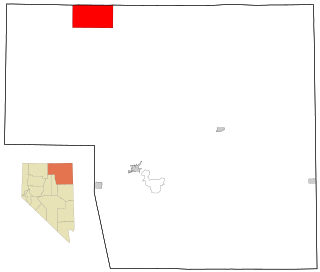
Owyhee is a census-designated place (CDP) in Elko County, Nevada, United States, along the banks of the Owyhee River. The population was 953 at the 2010 census. It is part of the Elko Micropolitan Statistical Area. It is the primary town of the federally recognized Shoshone-Paiute tribe's Duck Valley Indian Reservation, which covers portions of northern Nevada and southern Idaho, and the majority of its population are Native American.

Fort Irwin National Training Center is a major training area for the United States military and is a census-designated place located in the Mojave Desert in northern San Bernardino County, California. Fort Irwin is at an average elevation of 2,454 feet (748 m). It is located 37 miles (60 km) northeast of Barstow, in the Calico Mountains.

The Santa Rosa Mountains are a short mountain range in the Peninsular Ranges system, located east of the Los Angeles Basin and northeast of the San Diego metropolitan area of southern California, in the southwestern United States.
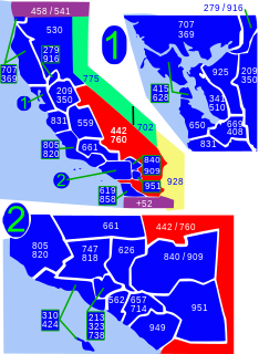
Area code 760 is a California telephone area code that was split from area code 619 on March 22, 1997. Area code 442 is an overlay of 760 that became effective on November 21, 2009. It encompasses much of the southeastern and southernmost portions of California. The area includes Imperial, Inyo, and Mono counties, as well as portions of San Diego, Riverside, San Bernardino, Los Angeles and Kern counties.

The Mohave Valley is a valley located mostly on the east shore of the south-flowing Colorado River in northwest Arizona. The valley extends into California's San Bernardino County; the northern side of the valley extends into extreme southeast Clark County, Nevada. The main part of the valley lies in southwest Mohave County, Arizona and is at the intersection of the southeast Mojave and northwest Sonoran deserts.

Campo is an unincorporated community in the Mountain Empire area of southeastern San Diego County, California, United States. The population was 2,684 at the 2010 census. For statistical purposes, the United States Census Bureau has defined Campo as a census-designated place (CDP). The census definition of the area may not precisely correspond to local understanding of the area with the same name.

Apache Pass, also known by its earlier Spanish name Puerto del Dado, is a historic mountain pass in the U.S. state of Arizona between the Dos Cabezas Mountains and Chiricahua Mountains at an elevation of 5,110 feet (1,560 m). It is approximately 20 miles (32 km) east-southeast of Willcox, Arizona, in Cochise County.

The Calico Mountains of California are a mountain range located in the Mojave Desert. The range spans San Bernardino and Inyo counties in California.

The Fort Apache Indian Reservation is an Indian reservation in northeastern Arizona, United States, encompassing parts of Navajo, Gila, and Apache counties. It is home to the federally recognized White Mountain Apache Tribe of the Fort Apache Reservation, a Western Apache tribe. It has a land area of 1.6 million acres and a population of 12,429 people as of the 2000 census. The largest community is in Whiteriver.
The Campo Indian Reservation is home to the Campo Band of Diegueño Mission Indians, also known as the Campo Kumeyaay Nation, a federally recognized tribe of Kumeyaay people in the southern Laguna Mountains, in eastern San Diego County, California. The reservation was founded in 1893 and is 16,512 acres (66.82 km2).

The Mojave Road, also known as Old Government Road, is a historic route and present day dirt road across what is now the Mojave National Preserve in the Mojave Desert in the United States. This rough road stretched 147 miles (237 km) from Beale's Crossing, to Fork of the Road location along the north bank of the Mojave River where the old Mojave Road split off from the route of the Old Spanish Trail/Mormon Road.
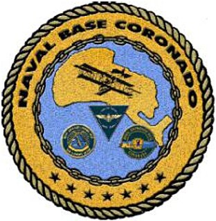
Naval Base Coronado (NBC) is a consolidated Navy installation encompassing eight military facilities stretching from San Clemente Island, located seventy miles west of San Diego, California, to the Mountain Warfare Training Camp Michael Monsoor and Camp Morena, located sixty miles east of San Diego.
The Nelson Range is a subrange of the Selkirk Mountains in the West Kootenay region of British Columbia, Canada. It is located south of the west arm of Kootenay Lake between the Salmo (W) and Kootenay Rivers (E) and also to the west of the south arm of Kootenay Lake. The range gets its name from the City of Nelson, which is on the south bank of the West Arm of Kootenay Lake and at the foot of the range's northwestern slopes.
The Cabazon Band of Mission Indians is a federally recognized tribe of Cahuilla Indians, located in Riverside County, California.
The Santa Rosa Band of Cahuilla Indians is a federally recognized tribe of Cahuilla Indians, located in Riverside County, California.

The Morongo Band of Mission Indians is a federally recognized tribe in California, United States. The main tribal groups are Cahuilla and Serrano. Tribal members also include Cupeño, Luiseño, and Chemehuevi Indians. Although many tribes in California are known as Mission Indians, some, such as those at Morongo, were never a part of the Spanish Missions in California.
Fort Thorn or Fort Thorne, originally Cantonment Garland, was a settlement and military outpost located on the west bank of the Rio Grande, northwest of present-day Hatch, and west of Salem in Doña Ana County, New Mexico, United States. It was named for 1st Lt. Herman Thorn of the 2nd U.S. Infantry drowned in the Colorado River in 1849. He had previously been an aide to General John Garland, the new commander of the Ninth Military District, that encompassed New Mexico Territory in 1853.

Victorio's War, or the Victorio Campaign, was an armed conflict between the Apache followers of Chief Victorio, the United States, and Mexico beginning in September 1879. Faced with arrest and forcible relocation from his homeland in New Mexico to San Carlos Indian Reservation in southeastern Arizona, Victorio led a guerrilla war across southern New Mexico, west Texas and northern Mexico. Victorio fought many battles and skirmishes with the United States Army and raided several settlements until the Mexican Army killed him and most of his warriors in October 1880 in the Battle of Tres Castillos. After Victorio's death, his lieutenant Nana led a raid in 1881.
Bitter Spring is a spring within the Fort Irwin National Training Center in San Bernardino County, California. It lies at an elevation of 1355 feet and is located in a valley between the Soda Mountains to the east, the Tiefort Mountains to the northwest, Alvord Mountain to the southwest and Cronese Mountains to the south and southeast.

The Sevenmile Mountains are a mountain range in central Gila County in the U.S. state of Arizona. The range has a maximum elevation of 6,629 ft (2,021 m) and a prominence of 989 ft (301 m). The highest peak is labelled Seven on the USGS topo sheet and has a topographic isolation of 13.35 miles. The majority of the southern end of the range is located on the San Carlos Apache Indian Reservation. The high point and the northwestern tip of the range is in the Tonto National Forest and is open to free range hiking. The mountains' high point is located just 3 miles east from a section of the U.S. Route 60 in Arizona in between Globe, Arizona and Show Low, Arizona. The southern end of the range that is inside the San Carlos Apache Indian Reservation should only be hiked with permission from the Reservation. The range is one of many that occur in the Arizona transition zone.
References
- ↑ "Tiefort Mountain - California, United States". peakery. Archived from the original on January 16, 2014.
- Allan, Stuart (2005). California Road and Recreation Atlas. Benchmark Maps. p. 96. ISBN 0-929591-80-1.
- U.S. Geological Survey Geographic Names Information System: Tiefort Mountains
Coordinates: 35°17′00″N116°33′23″W / 35.28333°N 116.55639°W
| | This San Bernardino County, California–related article is a stub. You can help Wikipedia by expanding it. |