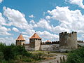
Tighina Fortress

Last updated

South side of the Tighina Fortress Cetatea Tighina 2021.jpg
South side of the Tighina Fortress

The Tighina Fortress (Romanian : Cetatea Tighina; renamed by the Turks as Bender) is a 15th-century fortress on the right bank of the Dniester River in Bender, Moldova, built from earth and wood during the reign of Prince Stephen the Great. In 1538 it was conquered by the Turkish sultan Suleiman the Magnificent, who ordered it to be rebuilt in stone and enlarged.

Contents

History

The earliest mention of Tighina, as a settlement and customs post, is found in the commercial privilege granted on October 6, 1408, by the Prince of Moldavia Alexander the Good to the merchants of Lviv. Later, throughout the 15th and 16th centuries, the name of Tighina is frequently recorded in medieval documents. In the Moldavian documents that mention the locality, in Tighina, along with the royal customs and the crossing, a guard is mentioned. In the only document from the Prince Stephen the Great (1457-1504) in which Tighina appears, the guard is also mentioned. [1]

As for the fortress of Tighina, 19th-century researchers, following the information circulating in previous centuries, accredited the idea that it was built in the 12th century by the Genoese, as well as Hotin and Cetatea Albă fortresses. The military historian Aleksander Zaschuk saw in the architecture of the inner citadel a pronounced western character. The first and only definite mention of the existence of the Moldavian fortification itself, of the fortress (probably of wood and earth), is found in the Moldavian-Polish Chronicle from the middle of the 16th century. It relates, referring to the Ottoman conquests of 1538, that the Turkish sultan Süleyman "took possession of the Moldavian fortress Tighina." [1]

Archaeological investigations of limited extent, carried out by the researcher Ion Hîncu in 1969, allowed the discovery of housing complexes and a defense ditch belonging to the 15th-16th centuries. Archaeological excavations have led to the identification of a fortification, probably of wood and earth, which preceded the later stone construction. The surface of the fortress' courtyard of circular or ovoid shape was covered with a layer of ashes. Ceramic and metal objects bear traces of fire. [1]

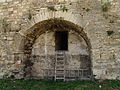
The fortress, having been rebuilt by Petru Rareș [ clarification needed ] and conquered in 1538 by the Turkish sultan Soliman the Magnificent, became the residence of the Turkish raya. Its old name was replaced by a new one, Bender, meaning "river port, berth". During this period, Soliman I ordered that the fortress be rebuilt in stone and enlarged according to the design of the architect Sinan, the reconstruction works being completed only in 1541.

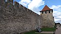
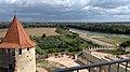
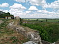
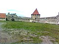
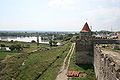
Using local resources and the work of the local peasants, the Ottomans turned the fortress into a well-established fighting outpost. At that time the fortress built of stone was a quadrangle surrounded on three sides by a very deep ditch.

By the end of the 16th century, Moldavian detachments had attacked the Bender fortress several times, but without any success. In the summer of 1574, John the Brave had besieged it with his army. Then in 1595 and 1600 Michael the Brave had made two attempts, but neither of the two rulers had any success. Around the same time, Bender was attacked by the Zaporozhian Cossacks. In the years 1705-1707 the works of strengthening this fortification of special military importance on behalf of Turks were continued by the prince Antioh Cantemir. In this last variant, the fortress consisted of an ensemble of 10 bastions and 11 towers surrounded by the same traditional defense ditch.

The bitter fate of the fortress ruled by the Turks made the chronicler Miron Costin write that "the fortress of Tighina has darkened". As a result of the three Russo-Turkish wars, it came under the rule of the Russian Empire, the Tsarist generals finding it very suitable for military barracks. From 1812 or rather from the second half of the 19th century,[ clarification needed ] the fortress of Bender gradually began to lose its former strategic importance.

Since 1991, the fortress has been under the control of the Transnistrian separatist regime, which restored it between 2008 and 2012. [2]

2021

2013

Before 2013

Historical portrayal

Related Research Articles

<span class="mw-page-title-main">Moldavia</span> Historical region and former principality in Central and Eastern Europe

Moldavia is a historical region and former principality in Central and Eastern Europe, corresponding to the territory between the Eastern Carpathians and the Dniester River. An initially independent and later autonomous state, it existed from the 14th century to 1859, when it united with Wallachia as the basis of the modern Romanian state; at various times, Moldavia included the regions of Bessarabia, all of Bukovina and Hertsa. The region of Pokuttya was also part of it for a period of time.

<span class="mw-page-title-main">Bender, Moldova</span> Municipality in Transnistria, Moldova

Bender or Bendery, also known as Tighina, is a city within the internationally recognized borders of Moldova under de facto control of the unrecognized Pridnestrovian Moldavian Republic (Transnistria) (PMR) since 1992. It is located on the western bank of the river Dniester in the Romanian historical region of Bessarabia.

<span class="mw-page-title-main">Bilhorod-Dnistrovskyi</span> City in Odesa Oblast, Ukraine

Bilhorod-Dnistrovskyi, historically known as Aq Kirmān or by other names, is a port city in Odesa Oblast, southwestern Ukraine. It is situated on the right bank of the Dniester Estuary leading to the Black Sea, in the historical region of Budjak. It also serves as the administrative center of Bilhorod-Dnistrovskyi Raion and is coterminous with Bilhorod-Dnistrovskyi urban hromada, one of the hromadas of Ukraine. It is the location of a large freight seaport. Population: 47,727.

<span class="mw-page-title-main">Budjak</span> Historical region in southwestern Ukraine

Budjak, also known as Budzhak, is a historical region that was part of Bessarabia from 1812 to 1940. Situated along the Black Sea, between the Danube and Dniester rivers, this multi-ethnic region covers an area of 13,188 km2 (5,092 sq mi) and is home to approximately 600,000 people. The majority of the region is now located in Ukraine's Odesa Oblast, while the remaining part is found in the southern districts of Moldova. The region is bordered to the north by the rest of Moldova, to the west and south by Romania, and to the east by the Black Sea and the rest of Ukraine.

<span class="mw-page-title-main">Khotyn</span> City in Chernivtsi Oblast, Ukraine

Khotyn is a city in Dnistrovskyi Raion, Chernivtsi Oblast of western Ukraine, located south-west of Kamianets-Podilskyi. It hosts the administration of Khotyn urban hromada, one of the hromadas of Ukraine. According to the 2001 Ukrainian census, it has a population of 11,124. Current population: 8,936.

<span class="mw-page-title-main">Battle of Vaslui</span> 1475 battle of the Moldavian-Ottoman Wars

The Battle of Vaslui was fought on 10 January 1475, between Stephen III of Moldavia and the Ottoman governor of Rumelia, Hadım Suleiman Pasha. The battle took place at Podul Înalt, near the town of Vaslui, in Moldavia. The Ottoman troops numbered up to 120,000, facing about 40,000 Moldavian troops, plus smaller numbers of allied and mercenary troops.

<span class="mw-page-title-main">Trajan's Wall</span> Eastern European fortifications made of earth

Trajan's Wall is the name used for several linear earthen fortifications (valla) found across Eastern Europe, Moldova, Romania, and Ukraine. Contrary to the name and popular belief, the ramparts were not built by Romans during Trajan's reign, but during other imperial periods. Furthermore, the association with the Roman Emperor may be a recent scholarly invention, only entering the imagination of the locals with the national awakening of the 19th century. Medieval Moldavian documents referred to the earthworks as Troian, likely in reference to a mythological hero in the Romanian and Slavic folklore. The other major earthen fortification in Romania, Brazda lui Novac, is also named after a mythological hero.

<span class="mw-page-title-main">Religion in Transnistria</span> Overview of religion in Transnistria

Pridnestrovian Moldavian Republic (Transnistria) official statistics show that 91 percent of the Transnistrian population adhere to Eastern Orthodox Christianity, with 4 percent adhering to the Catholic Church. Roman Catholics are mainly located in Northern Transnistria, a region with notable Polish minority.

<span class="mw-page-title-main">Battle of Khotyn (1673)</span> 1673 battle of the Polish–Ottoman War of 1672-76

The Battle of Khotyn or Battle of Chocim or Hotin War took place on 11 November 1673, where the forces of the Polish–Lithuanian Commonwealth under the Grand Hetman of the Polish Crown John Sobieski defeated Ottoman Empire forces, with Moldavian and Wallachian regiments, led by Husein Pasha. It reversed the fortunes of the previous year, when Commonwealth weakness led to the signing of the Treaty of Buchach, and allowed John Sobieski to win the upcoming royal election and become the King of Poland.

<span class="mw-page-title-main">Khotyn Fortress</span> Fortress complex in Chernivtsi Oblast, Ukraine

The Khotyn Fortress is a fortification complex located on the right bank of the Dniester River in Khotyn, Chernivtsi Oblast (province) of south - western Ukraine. It is situated on a territory of the historical northern Bukovina, a Romanian region which was occupied in 1940 by the Soviet Union following the Molotov–Ribbentrop Pact. The fortress is also located in a close proximity to another famous defensive structure, the Old Kamianets Castle of Kamianets-Podilskyi. Construction on the current stone Khotyn/Hotin fortress was started in 1375, while major improvements were made in the 1380s and in the 1460s, under the Moldavian princes, Alexander the Good, and Stephen the Great.

<span class="mw-page-title-main">Kamianets-Podilskyi Castle</span> Castle and fortress in Kamianets-Podilskyi, Ukraine

Kamianets-Podilskyi Castle is a former Ruthenian-Lithuanian castle and a later three-part Polish fortress located in the historic city of Kamianets-Podilskyi, Ukraine, in the historic region of Podolia in the western part of the country. Its name is attributed to the root word 'kamin', from the Slavic word for 'stone'.

<span class="mw-page-title-main">Neamț Citadel</span>

Neamț Citadel is a medieval fortress located in north-eastern part of Romania, near Târgu Neamț, Neamț County. It was built in 14th century Moldavia during Petru I of Moldavia's reign and expanded in the 15th century. The citadel played a key role in Stephen III of Moldavia's defense system, along with Suceava, Hotin, Soroca, Orhei, Tighina, Chilia and Cetatea Albă.

This deals with the History of Transnistria before it became part of the Russian Empire in 1792.

<span class="mw-page-title-main">Medzhybizh Fortress</span>

Medzhybizh Fortress also known as Medzhybizh Castle, is situated at the confluence of the Southern Bug and Buzhok rivers, in the town of Medzhybizh, Ukraine. Today the castle is part of the State Historical and Cultural Reserve.

<span class="mw-page-title-main">Soroca Fort</span> Historical and architectural monument of national importance in Moldova

The Soroca Fort is a historic fort in the Republic of Moldova, in the modern-day city of Soroca.

<span class="mw-page-title-main">Dacian fortress of Căpâlna</span>

Situated at the top of a steep hill, the Dacian fortress of Căpâlna was built in the second half of the 1st century BC as a military defense, guarding the entrance from the Sebeș Valley to the capital of the Dacian kingdom, Sarmizegetusa Regia.

The town of Maurocastrum, also known historically as Cetatea Alba in Romanian, was a settlement on the banks of the Dniester River, now the city of Bilhorod-Dnistrovskyi, Ukraine, in the 6th century BC. It later came under successive Greek, Roman and Byzantine rule. Under the Treaty of Nymphaion of 1261, the city came under the control of the Republic of Genoa. Called Mauricastro by them, it then became a base for trading by Genoese merchants with both the Byzantine Empire and the Mongol Empire.

Stephen V Locust, was Prince of Moldavia from 1538 to 1540. His nickname comes from a large locust invasion of the country that happened during his reign and led to harvest loss, and famine.

<span class="mw-page-title-main">Bilhorod-Dnistrovskyi fortress</span>

Bilhorod-Dnistrovskyi fortress or Akkerman fortress is a historical and architectural monument of the 13th-14th centuries. It is located in Bilhorod-Dnistrovskyi in the Odesa region of southwestern Ukraine, the historical Budjak.

<span class="mw-page-title-main">Terebovlia Castle</span>

Terebovlia castle is a ruined 17th-century castle in the town of Terebovlia in western Ukraine.

References

  1. 1 2 3 Eugen SAVA; Ion TENTIUC; Ana BOLDUREANU. "CETATEA TIGHINA/BENDER – UNA DINTRE CELE MAI ENIGMATICE FORTIFICAŢII MEDIEVALE DIN SPAŢIUL PRUTO-NISTREAN" [TIGHINA/BENDER FORT – ONE OF THE MOST ENIGMATIC MEDIEVAL FORTIFICATIONS IN THE PRUTO-NISTREAN AREA]. EuroEast Culture – Eastern Partnership Culture Programme (in Romanian). Archived from the original on 2021-08-14. Retrieved 2021-08-14.
  2. "Указ Президента ПМР от 19 апреля 2007 г. N 294 "О ВОССТАНОВЛЕНИИ И СОЗДАНИИ ИСТОРИЧЕСКОГО ВОЕННО-МЕМОРИАЛЬНОГО КОМПЛЕКСА "БЕНДЕРСКАЯ КРЕПОСТЬ"" [Decree of the President of the PMR dated April 19, 2007 N 294 "ON RESTORATION AND CREATION OF THE HISTORICAL MILITARY MEMORIAL COMPLEX "BENDERY FORTRESS"] (in Russian). bendery-fortress.com. 19 April 2007. Archived from the original on 2013-10-29. Retrieved 2013-04-14.

46°50′17″N29°29′15″E / 46.8381°N 29.4874°E / 46.8381; 29.4874