See also
Wikimedia Commons has media related to St. John's .
The timeline of St. John's history shows the significant events in the history of St. John's, Newfoundland and Labrador.
| Government | |
|---|---|
| Geography | |
| Sports | |
| Culture | |
| Transportation | |

Newfoundland and Labrador is the easternmost province of Canada, in the country's Atlantic region. The province comprises the island of Newfoundland and the continental region of Labrador, having a total size of 405,212 km2 (156,453 sq mi) As of January 1, 2024, the population of Newfoundland and Labrador was estimated to be 540,552. The island of Newfoundland is home to around 94 per cent of the province's population, with more than half residing in the Avalon Peninsula. Labrador shares a land border with both the province of Quebec and the territory of Nunavut on Killiniq Island. The French overseas collectivity of Saint Pierre and Miquelon lies about 20 km (12 mi) west of the Burin Peninsula.
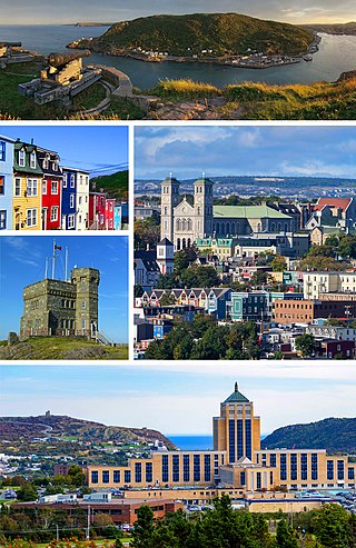
St. John's is the capital and largest city of the Canadian province of Newfoundland and Labrador. It is located on the eastern tip of the Avalon Peninsula on the island of Newfoundland. The city spans 446.04 km2 (172.22 sq mi) and is the easternmost city in North America.

The 16th century in Canada saw the first contacts, since the Norsemen 500 years earlier, between the indigenous peoples in Canada living near the Atlantic coast and European fishermen, whalers, traders, and explorers.

Bonavista is a town on the Bonavista Peninsula, Newfoundland in the Canadian province of Newfoundland and Labrador. Unlike many Newfoundland coastal settlements, Bonavista was built on an open plain, not in a steep cove, and thus had room to expand to its current area of 31.5 km2 (12.2 sq mi). Bonavista is located approximately 300 km by road from the provincial capital of St. John's.

Channel-Port aux Basques is a town at the extreme southwestern tip of Newfoundland fronting on the western end of the Cabot Strait. A Marine Atlantic ferry terminal is located in the town which is the primary entry point onto the island of Newfoundland and the western terminus of the Newfoundland and Labrador Route 1 in the province. The town was incorporated in 1945 and its population in the 2021 census was 3,547.

An outport is the term given for a small coastal community in the Canadian province of Newfoundland and Labrador. Originally, the term was used for coastal communities on the island of Newfoundland, but the term has now been adopted for those on the mainland area of Labrador as well.

Placentia is a town located in the Canadian province of Newfoundland and Labrador. It consists of the amalgamated communities of Placentia ("Townside"), Southeast Placentia, Freshwater, Dunville and Jerseyside and also includes the Argentia Industrial Park.

Carbonear is a town on the Avalon Peninsula in Newfoundland and Labrador, Canada. It overlooks the west side of Conception Bay and had a history long tied to fishing and shipbuilding. Since the late 20th century, its economy has changed to emphasize education, health care, retail, and industry. As of 2021, there were 4,696 people in the community.

Trepassey is a small fishing community located in Trepassey Bay on the south eastern corner of the Avalon Peninsula of Newfoundland and Labrador. It was in Trepassey Harbour where the flight of the Friendship took off, with Amelia Earhart on board, the first woman to fly across the Atlantic Ocean.
The province of Newfoundland and Labrador covers the period from habitation by Archaic peoples thousands of years ago to the present day.

Argentia is a Canadian commercial seaport and industrial park located in the Town of Placentia, Newfoundland and Labrador. It is situated on the southwest coast of the Avalon Peninsula and defined by a triangular shaped headland which reaches northward out into Placentia Bay creating a natural harbour 3 km (1.9 mi) in length.

Bay Bulls is a small fishing town in the province of Newfoundland and Labrador, Canada.
Bay de Verde is an incorporated town in Conception Bay on the northern tip of the Bay de Verde Peninsula of Newfoundland and Labrador, Canada. The first recorded inhabitants at Bay de Verde arrived in 1662. Bay de Verde became an incorporated town in 1950.
Bay Roberts is a town located on the north shore of Conception Bay on the northeastern Avalon Peninsula in the province of Newfoundland and Labrador, Canada. The growth of the local economy can be connected to the town's proximity to other major Newfoundland markets, by road and by water.

Fox Harbour is a small community on the Avalon Peninsula of Newfoundland. According to Statistics Canada in 2011, the population was 270. It is surrounded by hills. It is located close to Argentia, the site of the Naval Station Argentia. According to some sources, Fox Harbour got its name from tales of foxes that came down from the surrounding hills and ate the drying fish on the flakes. As well, the community was called Little Glocester before it became officially named Fox Harbour.
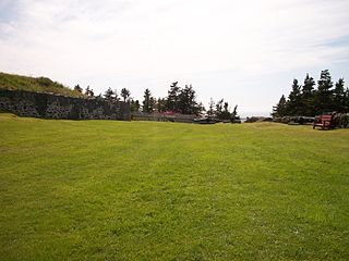
Castle Hill is an area containing the remains of both French and British fortifications, overlooking the town of Placentia in Newfoundland and Labrador, Canada. The site was originally established in order to protect the French fishing interests in Terre-Neuve (Newfoundland) and the approaches to the French colony of Canada.

Newfoundland is a large island within the Canadian province of Newfoundland and Labrador. It is situated off the eastern coast of the North American mainland and the geographical region of Labrador.

The Newfoundland expedition was a series of fleet manoeuvres and amphibious landings in the coasts of Newfoundland, Labrador and Saint Pierre and Miquelon carried out by the combined French and Spanish fleets during the French Revolutionary Wars. This expedition, composed of seven ships of the line and three frigates under the orders of Rear-Admiral Richery sailed from Cadiz in August 1796 accompanied by a much stronger Spanish squadron, commanded by General Solano, which had the aim of escorting it to the coast of Newfoundland.

Newfoundland was an English and, later, British colony established in 1610 on the island of Newfoundland, now the province of Newfoundland and Labrador. That followed decades of sporadic English settlement on the island, which was at first seasonal, rather than permanent. It was made a Crown colony in 1824 and a Dominion in 1907. Its economy collapsed during the Great Depression and on 16 February 1934, the Newfoundland legislature agreed to the creation of a six-member Commission of Government to govern the country. In 1949, the country voted to join Canada as the province of Newfoundland.
Division No. 1, Subdivision C is an unorganized subdivision on the Avalon Peninsula in Newfoundland and Labrador, Canada. It is in Division 1 and contains the unincorporated communities of Cape St. Mary's, Cuslett, Gooseberry Cove, Great Barasway, Lears Cove, Patrick's Cove-Angels Cove, Ship Cove and Stoney House.