Segeberg is a district in Schleswig-Holstein, Germany. It is bounded by the districts of Pinneberg, Steinburg and Rendsburg-Eckernförde, the city of Neumünster, the districts of Plön, Ostholstein and Stormarn, and the city state of Hamburg.
Stormarn is a district in Schleswig-Holstein, Germany. It is bounded by the districts of Segeberg and Ostholstein, the city of Lübeck, the district of Lauenburg, and the city-state of Hamburg.

Lüneburg Heath is a large area of heath, geest, and woodland in the northeastern part of the state of Lower Saxony in northern Germany. It forms part of the hinterland for the cities of Hamburg, Hanover and Bremen and is named after the town of Lüneburg. Most of the area is a nature reserve. Northern Low Saxon is still widely spoken in the region.

The Hamburg Metropolitan Region is a metropolitan area centred around the city of Hamburg in northern Germany, consisting of eight districts (Landkreise) in the federal state of Lower Saxony, six districts (Kreise) in the state of Schleswig-Holstein and two districts in the state of Mecklenburg-Vorpommern along with the city-state of Hamburg itself. It covers an area of roughly 26,000 square kilometres (10,000 sq mi) and is home to more than 5.1 million inhabitants.

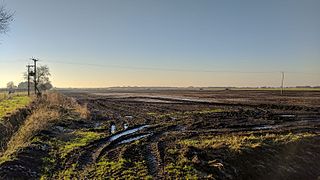
A kettle is a depression/hole in an outwash plain formed by retreating glaciers or draining floodwaters. The kettles are formed as a result of blocks of dead ice left behind by retreating glaciers, which become surrounded by sediment deposited by meltwater streams as there is increased friction. The ice becomes buried in the sediment and when the ice melts, a depression is left called a kettle hole, creating a dimpled appearance on the outwash plain. Lakes often fill these kettles; these are called kettle hole lakes. Another source is the sudden drainage of an ice-dammed lake. When the block melts, the hole it leaves behind is a kettle. As the ice melts, ramparts can form around the edge of the kettle hole. The lakes that fill these holes are seldom more than 10 m (33 ft) deep and eventually become filled with sediment. In acid conditions, a kettle bog may form but in alkaline conditions, it will be kettle peatland.
Chat Moss is a large area of peat bog that makes up 30 per cent of the City of Salford, in Greater Manchester, England. North of the Manchester Ship Canal and River Mersey, five miles (8 km) to the west of Manchester, it occupies an area of about 10.6 square miles (27.5 km2).
The city of Hamburg in Germany is made up of seven boroughs and subdivided into 104 quarters. Most of the quarters were former independent settlements. As of 2008 the areal organisation is regulated by the constitution of Hamburg and several laws.

The North German Plain or Northern Lowland is one of the major geographical regions of Germany. It is the German part of the North European Plain. The region is bounded by the coasts of the North Sea and the Baltic Sea to the north and Germany's Central Uplands to the south.

Raised bogs, also called ombrotrophic bogs, are acidic, wet habitats that are poor in mineral salts and are home to flora and fauna that can cope with such extreme conditions. Raised bogs, unlike fens, are exclusively fed by precipitation (ombrotrophy) and from mineral salts introduced from the air. They thus represent a special type of bog, hydrologically, ecologically and in terms of their development history, in which the growth of peat mosses over centuries or millennia plays a decisive role. They also differ in character from blanket bogs which are much thinner and occur in wetter, cloudier climatic zones.

The Harburg Hills are a low ridge in the northeastern part of the German state of Lower Saxony and the southern part of the city state of Hamburg. They are up to 155 metres (509 ft) high.

The region between the Elbe and Weser rivers forms the Elbe–Weser triangle, also rendered Elbe-Weser Triangle, in northern Germany. It is also colloquially referred to as the Nasses Dreieck or "wet triangle".
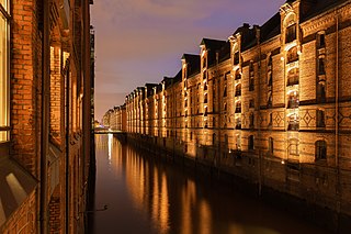
The Speicherstadt in Hamburg, Germany is the largest warehouse district in the world where the buildings stand on timber-pile foundations, oak logs, in this particular case. It is located in the port of Hamburg—within the HafenCity quarter—and was built from 1883 to 1927.
Land Hadeln is a historic landscape and former administrative district in Northern Germany with its seat in Otterndorf on the Lower Elbe, the lower reaches of the River Elbe, in the Elbe-Weser Triangle between the estuaries of the Elbe and Weser.

The Wittmoor bog trackway is the name given to each of two historic corduroy roads, trackway No. I being discovered in 1898 and trackway No. II in 1904 in the Wittmoor bog in northern Hamburg, Germany. The trackways date to the 4th and 7th century AD, both linked the eastern and western shores of the formerly inaccessible, swampy bog. A part of the older trackway No. II dating to the period of the Roman Empire is on display at the permanent exhibition of the Archaeological Museum Hamburg in Harburg, Hamburg.

The Bishop's Tower, or Bishop's Castle, is an archaeological site in the historic city center of Hamburg, Germany, containing the oldest known remains of a stone building in the city. The site includes the foundations of a circular tower and a well, originally believed to represent the 11th-century stone residence of Archbishop Adalbrand of Bremen. Later finds, however, disproved this theory and it is now considered to be part of a 12th-century defensive structure.
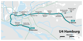
The U4 is a line of the Hamburg U-Bahn, which opened in 2012, serving 12 stations. It is the shortest line of the network, with a length of 11.9 kilometres (7.39 mi) and from Jungfernstieg to Billstedt it shares tracks with the U2.

Barmbek-Süd (help·info) is a quarter of Hamburg, Germany, in the borough of Hamburg-Nord. It is located in the east of Hamburg-Nord, approximately five kilometers from Hamburg city center. Barmbek-Süd is a densely built-up area.
Bergstedt is a quarter of Hamburg, Germany, in the borough of Wandsbek. It is located on the northeastern border of the borough and of the city. It is part of the area of Walddörfer. In 2016 10,687 lived in Bergstedt.

Billbrook is a quarter of Hamburg, Germany, in the borough of Hamburg-Mitte. It is located on the southeastern border of the borough adjacent to the borough of Bergedorf. Billbrook is located in a swamp area near the Elbe and Bille rivers, which is described by the name, meaning Brook at the river Bille. 2,198 people lived in Billbrook in 2016.

Curslack is a quarter of Hamburg, Germany, in the borough of Bergedorf. It is located in the eastern part of the borough, which lies in the southeast of Hamburg.
