Oriental Mindoro, is a province in the Philippines located on the island of Mindoro under Mimaropa region in Luzon, about 140 kilometres (87 mi) southwest of Manila. The province is bordered by the Verde Island Passage and the rest of Batangas to the north, by Marinduque, Maestre de Campo Island, Tablas Strait and the rest of Romblon to the east, by Semirara and the rest of Caluya Islands, Antique to the south, and by Occidental Mindoro to the west. Calapan, the only city in the island, is the provincial capital.

Tourism in Australia is an important part of the Australian economy, and comprises domestic and international visitors. In the financial year 2018/19, tourism was Australia's fourth-largest export and over the previous decade was growing faster than national GDP growth. At the time it represented 3.1% of Australia's GDP contributing A$60.8 billion to the national economy.
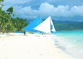
Boracay is a resort island in the Western Visayas region of the Philippines, located 0.8 kilometers (0.50 mi) off the northwest coast of Panay. It has a total land area of 10.32 square kilometers (3.98 sq mi), under the jurisdiction of three barangays in Malay, Aklan. Boracay had a population of 32,267 in 2015, including the Ati people who were the original inhabitants of the land, although commercial development has led to their severe marginalization over the years.
Santa Maria, officially the Municipality of Santa Maria, is a 1st class Highly urbanized municipality in the province of Bulacan, Philippines. According to the 2020 census, it has a population of 289,820 people. representing 7.8% of the population of the province.

Pandan, officially the Municipality of Pandan, is a 4th class municipality in the province of Antique, Philippines. According to the 2020 census, it has a population of 35,965 people. Making it 7th most populous municipality in the province of Antique.

Bauan, officially the Municipality of Bauan, is a 1st class municipality in the province of Batangas, Philippines. According to the 2020 census, it has a population of 90,819 people.

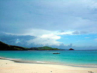
Siargao is a tear-drop shaped island in the Philippine Sea situated 196 kilometers southeast of Tacloban. It has a land area of approximately 437 square kilometres (169 sq mi). The east coast is relatively straight with one deep inlet, Port Pilar. The coastline is marked by a succession of reefs, small points and white, sandy beaches. The neighboring islands and islets have similar landforms.

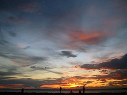
Tourism is an important sector for Philippine economy. The travel and tourism industry contributed 12.7% to the country's GDP in 2019. The country is known for having its rich biodiversity as its main tourist attraction. Popular destinations among tourists include Boracay, Palawan, and Siargao. Despite potential, the Philippines has lagged in tourism industry behind some of its Southeast Asian neighbors due to political and social problems.

Panglao is an island in the north Bohol Sea, located in the Central Visayas region of the Visayas island group, in the south-central Philippines.
Montenegro is one of the fastest-growing tourist destinations. In 2007, over a million tourists visited Montenegro, making some 7.3 million overnight stays. This accounted for some 480 million euros in tourism revenue in 2007. In 2015, tourism realised over 1.7 million arrivals, with a further increase in 2016. In the same year, the coastal town of Kotor was named the best city to visit by Lonely Planet, whereas the country itself is continuously included in touristic top lists. With a total of 1.8 million visitors in 2016, the nation became the 36th most popular country to travel to in Europe. Montenegro was further visited by over 2 million tourists in 2017. The Government aims to attract greenfield investments, which should make best use of undeveloped parts of the coast, such as Jaz Beach, Velika Plaža, Ada Bojana and Buljarica.

Verde Island is a volcanic island situated along the bodies of Verde Island Passage between the islands of Luzon and Mindoro, Philippines. It was in 1988 when a small village was connected to mains electricity through the effort of a European project using technologies such as solar panels for the island's self-sufficiency. Since then, it has been declared by the Philippine Tourism Authority as one of the country's marine reserves.
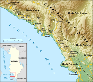
The Albanian Riviera, also popularly known as Bregu, is a coastline along the Northeastern Ionian Sea in the Mediterranean Sea encompassing the districts of Sarandë and Vlorë in Southwestern Albania. It forms an important section of the Albanian Ionian Sea Coast dotted with the villages of Palasë, Dhërmi, Vuno, Himara, Qeparo, Borsh, Piqeras, Lukovë and the city of Sarandë.

Nyali is a residential area and Sub-County within Mombasa City, located on the mainland north of Mombasa County. It is connected to Mombasa Island by the New Nyali Bridge. Nyali is known for its many high-class hotels and residential houses, modern standards, and long white sand beaches making it a popular destination for both local and foreign tourists.
Guintinua is one of the two major islands in the Calaguas group. It is located in Vinzons, Camarines Norte, Philippines, and is part of the Barangay Banocboc. The island is the second largest in the Calaguas group, measuring almost 6.5 km (4.0 mi) long.
Maculabo is an island of the Calaguas group of islands in Camarines Norte province of the Philippines. Although part of the Calaguas group, the island is under the jurisdiction of the municipality of Paracale, Camarines Norte. The island serves as a major stop-over going to Tinaga Island where the well-known long beach Mahabang Buhangin is located. The island is about four kilometres (2.5 mi) long. Locals reside on parts of the Island with farming and fishing as their main source of income.
Calaguas, also known as Calaguas Islands, is a group of islands located in the Philippine province of Camarines Norte. It includes the major islands of Tinaga Island and Guintinua Island, the minor Maculabo Island, as well as several other minor. The group of islands is around 200 km away from the capital city of Manila and can be accessed through the ports at Paracale and Daet, Camarines Norte.

Tofino is a town of approximately 2,516 residents on the west coast of Vancouver Island in the Canadian province of British Columbia. The District of Tofino is located at the western terminus of Highway 4 on the tip of the Esowista Peninsula at the southern edge of Clayoquot Sound. It is situated in the traditional territory of the Tla-o-qui-aht First Nations.
Alibijaban is a small island located off the southeastern coast of Bondoc Peninsula in the Philippines. It belongs administratively to the municipality of San Andres, Quezon province, and is coterminous with the barangay of the same name. With a population of 1,643 inhabitants in 2015, it is the smallest of seven barangays in San Andres.