Tindo | |
|---|---|
 | |
 Tindo | |
| Coordinates: Coordinates: 10°00′N10°50′W / 10°N 10.83°W | |
| Country | |
Tindo is a sub-prefecture in Guinea. Its population is 5,052 according to 2014 census. [1] [2] [3]
Tindo | |
|---|---|
| | |
| Tindo | |
| Coordinates: Coordinates: 10°00′N10°50′W / 10°N 10.83°W | |
| Country | |
Tindo is a sub-prefecture in Guinea. Its population is 5,052 according to 2014 census. [1] [2] [3]

Okinawa Prefecture is a prefecture of Japan. Okinawa Prefecture is the southernmost and westernmost prefecture of Japan, has a population of 1,457,162 and has a geographic area of 2,281 km2.

Aomori Prefecture is a prefecture of Japan in the Tōhoku region. The prefecture's capital, largest city, and namesake is the city of Aomori. Aomori is the northernmost prefecture on Japan's main island, Honshu, and is bordered by the Pacific Ocean to the east, Iwate Prefecture to the southeast, Akita Prefecture to the southwest, the Sea of Japan to the west, and Hokkaido across the Tsugaru Strait to the north. Aomori Prefecture is the 8th-largest prefecture, with an area of 9,645.64 km2 (3,724.20 sq mi), and the 31st-most populous prefecture, with more than 1.2 million people. Approximately 45 percent of Aomori Prefecture's residents live in its two core cities, Aomori and Hachinohe, which lie on coastal plains. The majority of the prefecture is covered in forested mountain ranges, with population centers occupying valleys and plains. Aomori is the third-most populous prefecture in the Tōhoku region, after Miyagi Prefecture and Fukushima Prefecture. Mount Iwaki, an active stratovolcano, is the prefecture's highest point, at almost 1,624.7 m (5,330 ft).
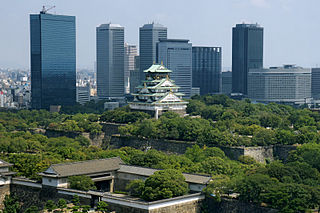
Osaka Prefecture is a prefecture of Japan located in the Kansai region of Honshu. Osaka Prefecture has a population of 8,778,035 and has a geographic area of 1,905 square kilometres (736 sq mi). Osaka Prefecture borders Hyōgo Prefecture to the northwest, Kyoto Prefecture to the north, Nara Prefecture to the southeast, and Wakayama Prefecture to the south.

Kyoto Prefecture is a prefecture of Japan located in the Kansai region of Honshu. Kyoto Prefecture has a population of 2,561,358 and has a geographic area of 4,612 square kilometres (1,781 sq mi). Kyoto Prefecture borders Fukui Prefecture to the northeast, Shiga Prefecture to the east, Mie Prefecture to the southeast, Nara Prefecture and Osaka Prefecture to the south, and Hyōgo Prefecture to the west.

Fukuoka Prefecture is a prefecture of Japan located on the island of Kyūshū. Fukuoka Prefecture has a population of 5,109,323 and has a geographic area of 4,986 km2. Fukuoka Prefecture borders Saga Prefecture to the southwest, Kumamoto Prefecture to the south, and Ōita Prefecture to the southeast.

Fukushima Prefecture is a prefecture of Japan located in the Tōhoku region of Honshu. Fukushima Prefecture has a population of 1,810,286 and has a geographic area of 13,783 square kilometres (5,322 sq mi). Fukushima Prefecture borders Miyagi Prefecture and Yamagata Prefecture to the north, Niigata Prefecture to the west, Gunma Prefecture to the southwest, and Tochigi Prefecture and Ibaraki Prefecture to the south.

Faranah is a prefecture located in the Faranah Region of Guinea. The capital is Faranah. The prefecture covers an area of 12,966 km2 and has an estimated population of 280,511.

The metropolitan area of Adelaide, South Australia is served by a wide variety of transport. Being centrally located on the Australian mainland, it forms a hub for east–west and north–south routes. The road network includes major expressways such as the Southern Expressway, the South Eastern Freeway, the Port River Expressway, the Northern Expressway and the South Road Superway. The city also has a public transport system managed by Adelaide Metro, consisting of a contracted bus system including the O-Bahn Busway, six metropolitan railway lines, and the Glenelg-Adelaide-Hindmarsh Tram. According to a study conducted by the Australian Bureau of Statistics, Adelaide has the highest passenger vehicle travel to work (84%) and the second lowest proportion of people walking to work (2.9%)–something that is being combated by the South Australian government in an effort to increase citizen ridership and use of public transport.
Events in the year 1992 in Japan. It corresponds to Heisei 4 (平成4年) in the Japanese calendar.
The Bayshore Route signed as Route B, is one of the routes of the tolled Shuto Expressway system in the Greater Tokyo Area. The Bayshore Route is a 62.1-kilometer (38.6 mi) stretch of toll highway that runs from the Kanazawa ward of Yokohama in the west, northeast to the city of Ichikawa in Chiba Prefecture in the east. Opened in phases beginning in 1976 and ending in 2001, it is an important route that runs between the artificial islands lining the western shore of Tokyo Bay by way of bridges and sub-sea tunnels that bypass central Tokyo.

National Route 394 is a national highway in the Japanese prefecture of Aomori. Route 394 stretches 185 km from National Routes 279 and 338 in Mutsu southwest to National Route 7 in Hirosaki.
Shimmer Chinodya is a Zimbabwean novelist.
Events in the year 1942 in Japan.

Prairie is a rural town and locality in the Flinders Shire, Queensland, Australia. In the 2016 census the locality of Prairie had a population of 143 people.
Events in the year 1940 in Japan. It corresponds to Shōwa 15 (昭和15年) in the Japanese calendar.
Events from the year 1935 in Japan.
Events of the year 1960 in Japan. It corresponds to Shōwa 35 (昭和35年) in the Japanese calendar.
The following is an overview of the year 2018 in Japan.
Capital: Faranah | ||
| Sub-prefectures |  | |