Related Research Articles

Tallahatchie County is a county in the U.S. state of Mississippi. At the 2010 census, the population was 15,378. Its county seats are Charleston and Sumner.

Issaquena County is a county located in the U.S. state of Mississippi. As of the 2010 census, the population was 1,406, making it the least populous county in the United States east of the Mississippi River. Its county seat is Mayersville. With a per-capita income of $18,598, Issaquena County is the poorest county in the United States.

Bolivar County is a county located on the western border of the U.S. state of Mississippi. As of the 2010 census, the population was 34,145. Its county seats are Rosedale and Cleveland. The county is named in honor of Simón Bolívar, early 19th-century leader of the liberation of several South American colonies from Spain.
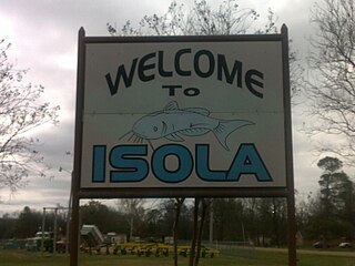
Isola is a town in Humphreys County, Mississippi, United States, on the banks of Lake Dawson. The population was 713 at the 2010 census, down from 768 at the 2000 census.

Des Allemands is an unincorporated community and census-designated place (CDP) in Lafourche and St. Charles parishes in the southeastern part of the U.S. state of Louisiana. The population was 2,505 at the 2010 census. The town, known as the "Catfish Capital of the Universe", is along the Bayou des Allemands, which is the boundary of Lafourche and St. Charles parishes. Lac des Allemands is located northwest of the town. The ZIP code for Des Allemands is 70030.
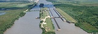
The Gulf Intracoastal Waterway is the portion of the Intracoastal Waterway located along the Gulf Coast of the United States. It is a navigable inland waterway running approximately 1,050 mi (1,690 km) from Carrabelle, Florida, to Brownsville, Texas.

The Tallahatchie River is a river in Mississippi which flows 230 miles (370 km) from Tippah County, through Tallahatchie County, to Leflore County, where it joins the Yalobusha River to form the Yazoo River. The river is navigable for about 100 miles.

The Battle of Chickasaw Bayou, also called the Battle of Walnut Hills, fought December 26–29, 1862, was the opening engagement of the Vicksburg Campaign during the American Civil War. Confederate forces under Lt. Gen. John C. Pemberton repulsed an advance by Union Maj. Gen. William T. Sherman that was intended to lead to the capture of Vicksburg, Mississippi.

The Battle of Georgia Landing was fought October 27, 1862 in Labadieville, Assumption Parish, Louisiana, as part of the Operations in LaFourche District (1862), during the American Civil War.
Chickasaw Bayou is a stream in the U.S. state of Mississippi. It is a tributary to the Yazoo River.

The Tallahatchie National Wildlife Refuge was established in 1990 and consists of 4,083 acres (16.52 km2) in Grenada and Tallahatchie counties. Topography is relatively flat and land has been subject to extensive clearing and drainage for commodity crops, including cotton before and after the Civil War. Upon acquisition the refuge lands consisted mostly of agricultural fields. Since then, nearly 1,300 acres (5.3 km2) have been reforested. The unit's largest continuous tract is a patchwork of cultivated farmlands, old fields, and small scattered hardwood bottomland forests bisected by the meandering Tippo Bayou, which is its centerpiece.
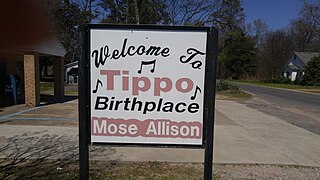
Tippo is an unincorporated community located in Tallahatchie County, Mississippi, United States, located approximately 10 miles (16 km) from Swan Lake; 11 miles (18 km) northeast of Glendora; and approximately 14 miles (23 km) from Charleston. Tippo is located at the intersection of Tippo and Sharkey roads.
WKXY is a radio station airing a country music format. The station is licensed to Merigold, Mississippi and broadcasts on 92.1 mHz. WKXY is owned by Delta Radio Network LLC. The WKXY studio is located at 3965 Highway 61 North in Cleveland, Mississippi, and the transmitter site is located on East Mound Bayou Road, near the town of Mound Bayou, Mississippi.

Needmore is a ghost town in Tallahatchie County, Mississippi, United States.
James Bayou Township is an inactive township in Mississippi County, in the U.S. state of Missouri.
St. James Township is an inactive township in Mississippi County, in the U.S. state of Missouri.
Bayou Costapia is a stream in the U.S. state of Mississippi. It is a tributary to the Biloxi River.
Pelucia Bayou is a stream in the U.S. state of Mississippi.
Skillikalia Bayou is a stream in the U.S. state of Mississippi.
Tokeba Bayou is a stream in the U.S. state of Mississippi.
References
- ↑ U.S. Geological Survey Geographic Names Information System: Tippo Bayou
- ↑ Baca, Keith A. (2007). Native American Place Names in Mississippi. University Press of Mississippi. p. 114. ISBN 978-1-60473-483-6.
Coordinates: 33°42′31″N90°11′21″W / 33.7087278°N 90.1892525°W
| This article related to a river in Mississippi is a stub. You can help Wikipedia by expanding it. |