
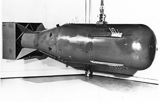
The Tsar Bomba, also known by the alphanumerical designation "AN602", was a thermonuclear aerial bomb, and the most powerful nuclear weapon ever created and tested. The Soviet physicist Andrei Sakharov oversaw the project at Arzamas-16, while the main work of design was by Sakharov, Viktor Adamsky, Yuri Babayev, Yuri Smirnov, and Yuri Trutnev. The project was ordered by Nikita Khrushchev in July 1961 as part of the Soviet resumption of nuclear testing after the Test Ban Moratorium, with the detonation timed to coincide with the 22nd Congress of the Communist Party of the Soviet Union.
Nuclear weapons tests are experiments carried out to determine nuclear weapons' effectiveness, yield, and explosive capability. Testing nuclear weapons offers practical information about how the weapons function, how detonations are affected by different conditions, and how personnel, structures, and equipment are affected when subjected to nuclear explosions. However, nuclear testing has often been used as an indicator of scientific and military strength. Many tests have been overtly political in their intention; most nuclear weapons states publicly declared their nuclear status through a nuclear test.

Severny Island is a Russian Arctic island. It is the northern island of the Novaya Zemlya archipelago. It was historically called Lütke Land after Friedrich Benjamin von Lütke, who explored it. It lies approximately 400 km north of the Russian mainland. It has an area of 48,904 square kilometres (18,882 sq mi), making it the 30th-largest island in the world and the 3rd-largest uninhabited island in the world. It is part of Russian Arctic National Park.
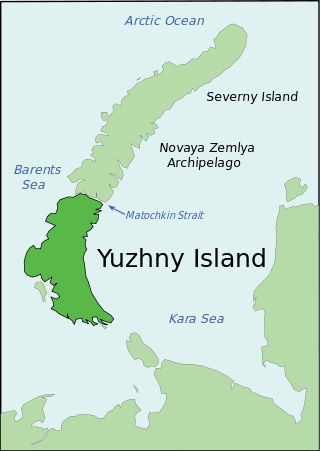
Yuzhny is the southern island of the Novaya Zemlya archipelago, lying north of Russia. It has an area of 33,275 square kilometres (12,800 sq mi), which while smaller than the northern island of Severny, makes it one of the largest islands in the world. It is separated from Severny Island by the narrow Matochkin Strait, which is covered with ice most of the year. West of Yuzhny Island lies the Barents Sea, and to the east the Kara Sea.
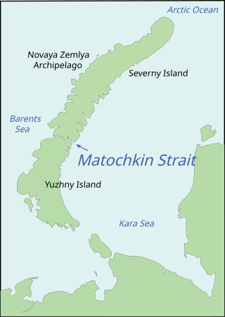
Matochkin Strait or Matochkin Shar is a 323 km2 (125 sq mi) strait, structurally a fjord, between the Severny and Yuzhny Islands of Novaya Zemlya. It connects the Barents Sea and the Kara Sea.
Amchitka is a volcanic, tectonically unstable and uninhabited island in the Rat Islands group of the Aleutian Islands in southwest Alaska. It is part of the Alaska Maritime National Wildlife Refuge. The island, with a land area of roughly 116 square miles (300 km2), is about 42 miles (68 km) long and 1 to 4 miles wide. The area has a maritime climate, with many storms, and mostly overcast skies.
Peaceful nuclear explosions (PNEs) are nuclear explosions conducted for non-military purposes. Proposed uses include excavation for the building of canals and harbours, electrical generation, the use of nuclear explosions to drive spacecraft, and as a form of wide-area fracking. PNEs were an area of some research from the late 1950s into the 1980s, primarily in the United States and Soviet Union.

Underground nuclear testing is the test detonation of nuclear weapons that is performed underground. When the device being tested is buried at sufficient depth, the nuclear explosion may be contained, with no release of radioactive materials to the atmosphere.
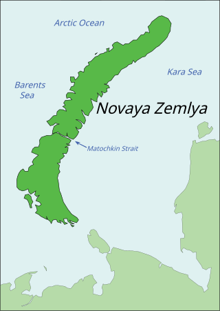
Novaya Zemlya is an archipelago in northern Russia. It is situated in the Arctic Ocean, in the extreme northeast of Europe, with Cape Flissingsky, on the northern island, considered the easternmost point of Europe. To Novaya Zemlya's west lies the Barents Sea and to the east is the Kara Sea.
Sukhoy Nos is a cape on Severny Island, the northern island of the archipelago Novaya Zemlya, projecting westward into the Barents Sea. The site lies near the southwestern corner of the island, 15 km (9.3 mi) from Mityushikha Bay, north of Matochkin Strait, which separates Severny from Yuzhny Island, the southern island of the archipelago.

On 12 February 2013, North Korean state media announced it had conducted an underground nuclear test, its third in seven years. A tremor that exhibited a nuclear bomb signature with an initial magnitude 4.9 was detected by the China Earthquake Networks Center, Preparatory Commission for the Comprehensive Nuclear-Test-Ban Treaty Organization and the United States Geological Survey. In response, Japan summoned an emergency United Nations meeting for 12 February and South Korea raised its military alert status. It is not known whether the explosion was nuclear or a conventional explosion designed to mimic a nuclear blast; as of two days after the blast, Chinese, Japanese, and South Korean investigators had failed to detect any radiation.

The Soviet Union's 1964 nuclear test series was a group of 9 nuclear tests conducted in 1964. These tests followed the 1962 Soviet nuclear tests series and preceded the 1965 Soviet nuclear tests series.
The Soviet Union's 1962 nuclear test series was a group of 78 nuclear tests conducted in 1962. These tests followed the Soviet Project K nuclear tests series and preceded the 1964 Soviet nuclear tests series.
The Soviet Union's 1961 nuclear test series was a group of 57 nuclear tests conducted in 1961. These tests followed the 1958 Soviet nuclear tests series and preceded the Soviet Project K nuclear tests series.
The Soviet Union's 1958 nuclear test series was a group of 36 nuclear tests conducted in 1958. These tests followed the 1957 Soviet nuclear tests series and preceded the 1961 Soviet nuclear tests series.
The Soviet Union's 1957 nuclear test series was a group of 16 nuclear tests conducted in 1957. These tests followed the 1956 Soviet nuclear tests series and preceded the 1958 Soviet nuclear tests series.
The Soviet Union's 1955 nuclear test series was a group of 7 nuclear tests conducted in 1955. These tests followed the 1954 Soviet nuclear tests series and preceded the 1956 Soviet nuclear tests series.
The Soviet Union's 1972 nuclear test series was a group of 24 nuclear tests conducted in 1972. These tests followed the 1971 Soviet nuclear tests series and preceded the 1973 Soviet nuclear tests series.
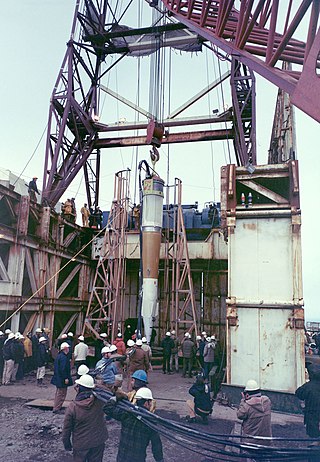
Mount Lazarev is a massif on the northern portion of Yuzhny Island, Novaya Zemlya, in Russia. It was used for many Soviet nuclear tests, starting with the first underground nuclear test on Novaya Zemlya, 18 September 1964, which may have resulted in tired mountain syndrome.
