Tiszacsege | |||
|---|---|---|---|
| |||
 Tiszacsege | |||
| Coordinates: 47°42′N21°00′E / 47.700°N 21.000°E | |||
| Country | |||
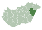
| County | Hajdú-Bihar | ||
| District | Balmazújváros | ||
| Area | |||
| • Total | 136.4 km2 (52.7 sq mi) | ||
| Population (2015) | |||
| • Total | 4,713 [1] | ||
| • Density | 34.6/km2 (90/sq mi) | ||
| Time zone | UTC+1 (CET) | ||
| • Summer (DST) | UTC+2 (CEST) | ||
| Postal code | 4066 | ||
| Area code | (+36) 52 | ||
| Website | www | ||


Tiszacsege is a town in Hajdú-Bihar county, in the Northern Great Plain region of eastern Hungary.

A town is a human settlement. Towns are generally larger than villages but smaller than cities, though the criteria to distinguish them vary considerably between different parts of the world.

The Northern Great Plain is a statistical region of Hungary. It is part of the Great Plain and North region. The Northern Great Plain includes the counties of Hajdú-Bihar, Jász-Nagykun-Szolnok, and Szabolcs-Szatmár-Bereg, with a total area of 17,749 km2 (6,853 sq mi) and a population of around 1.5 million.
In geography, regions are areas that are broadly divided by physical characteristics, human impact characteristics, and the interaction of humanity and the environment. Geographic regions and sub-regions are mostly described by their imprecisely defined, and sometimes transitory boundaries, except in human geography, where jurisdiction areas such as national borders are defined in law.