
Kiribati, officially the Republic of Kiribati, is an island country in the Micronesia subregion of Oceania in the central Pacific Ocean. Its permanent population is over 119,000 as of the 2020 census, with more than half living on Tarawa atoll. The state comprises 32 atolls and one remote raised coral island, Banaba. Its total land area is 811 km2 (313 sq mi) dispersed over 3,441,810 km2 (1,328,890 sq mi) of ocean.

The islands which now form the Republic of Kiribati have been inhabited for at least seven hundred years, and possibly much longer. The initial Austronesian peoples’ population, which remains the overwhelming majority today, was visited by Polynesian and Melanesian invaders before the first European sailors visited the islands in the 17th century. For much of the subsequent period, the main island chain, the Gilbert Islands, was ruled as part of the British Empire. The country gained its independence in 1979 and has since been known as Kiribati.
Nauru, officially the Republic of Nauru and formerly known as Pleasant Island, is an island country and microstate in Micronesia, part of Oceania in the Central Pacific. Its nearest neighbour is Banaba of Kiribati, about 300 km (190 mi) to the east. It lies northwest of Tuvalu, 1,300 km (810 mi) northeast of Solomon Islands, east-northeast of Papua New Guinea, southeast of the Federated States of Micronesia and south of the Marshall Islands. With an area of only 21 km2 (8.1 sq mi), Nauru is the third-smallest country in the world, larger than only Vatican City and Monaco, making it the smallest republic and island nation. Its population of about 10,800 is the world's third-smallest larger than only Vatican City and Tuvalu.
The history of human activity in Nauru, an island country in the Pacific Ocean, began roughly 3,000 years ago when clans settled the island.

The Gilbert Islands are a chain of sixteen atolls and coral islands in the Pacific Ocean, about halfway between Papua New Guinea and Hawaii. They constitute the main part of the nation of Kiribati.

The Gilbert and Ellice Islands in the Pacific Ocean were part of the British Empire from 1892 to 1976. They were a protectorate from 1892 to 12 January 1916, and then a colony until 1 January 1976. The history of the colony was mainly characterized by phosphate mining on Ocean Island. In October 1975, these islands were divided by force of law into two separate colonies, and they became independent nations shortly thereafter: the Ellice Islands became Tuvalu in 1978, and the Gilbert Islands became part of Kiribati in 1979.
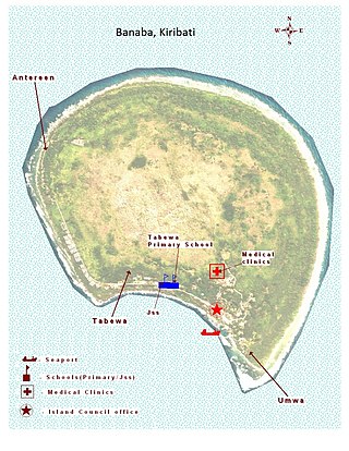
Banaba is an island of Kiribati in the Pacific Ocean. A solitary raised coral island west of the Gilbert Island Chain, it is the westernmost point of Kiribati, lying 185 miles (298 km) east of Nauru, which is also its nearest neighbour. It has an area of six square kilometres (2.3 sq mi), and the highest point on the island is also the highest point in Kiribati, at 81 metres (266 ft) in height. Along with Nauru and Makatea, it is one of the important elevated phosphate-rich islands of the Pacific.

Ieremia Tienang Tabai is an I-Kiribati politician who served as the first Beretitenti President of the Republic of Kiribati, after being the youngest ever Chief minister of the Commonwealth of Nations and then becoming the youngest ever head of State. During his presidency, he was described as being the most able leader of the Pacific island states.
The Micronesians or Micronesian peoples are various closely related ethnic groups native to Micronesia, a region of Oceania in the Pacific Ocean. They are a part of the Austronesian ethnolinguistic group, which has an Urheimat in Taiwan.
Rabi is a volcanic island in northern Fiji. It is an outlier to Taveuni, in the Vanua Levu Group. It covers an area of 66.3 square kilometers, reaching a maximum altitude of 463 meters and has a shoreline of 46.2 kilometers. With a population of around 5,000, Rabi is home to the Banabans who are the indigenous landowners of Ocean Island; the indigenous Fijian community that formerly lived on Rabi was moved to Taveuni after the island was purchased by the British government. The original inhabitants still maintain their links to the island, and still use the Rabi name in national competitions.

Sir Albert Fuller Ellis was an Australian prospector in the Pacific. He discovered phosphate deposits on the Pacific islands of Nauru and Banaba in 1900. He was the British Phosphate Commissioner for New Zealand from 1921 to 1951.
The British Phosphate Commissioners (BPC) was a board of Australian, British, and New Zealand representatives who managed extraction of phosphate from Christmas Island, Nauru, and Banaba from 1920 until 1981.

Makatea, or Mangaia-te-vai-tamae, is a raised coral atoll in the northwestern part of the Tuamotus, which is a part of the French overseas collectivity of French Polynesia. It is located 79 kilometres (49 mi) southwest from Rangiroa to the west of the Palliser group, which also is in French Polynesia. Makatea is surrounded by spectacular cliffs, rising to a plateau 80 metres (260 ft) above sea level. This island is 7.5 kilometres (4.7 mi) long, with a maximum width of 7 kilometres (4.3 mi) in the south. It is 24 square kilometres (9.3 sq mi) in area. Makatea is one of the only four islands of the Tuamotu Archipelago that do not take the form of a typical atoll.
John T. Arundel was an English entrepreneur who was instrumental in the development of the mining of phosphate rock on the Pacific islands of Nauru and Banaba. Williams & Macdonald (1985) described J. T. Arundel as "a remarkable example of that mid-Victorian phenomenon, the upright, pious and adventurous Christian English businessman."
Nauruan nationality law is regulated by the 1968 Constitution of Nauru, as amended; the Naoero Citizenship Act of 2017, and its revisions; custom; and international agreements entered into by the Nauruan government. These laws determine who is, or is eligible to be, a national of Nauru. The legal means to acquire nationality, formal membership in a nation, differ from the domestic relationship of rights and obligations between a national and the nation, known as citizenship. Nauruan nationality is typically obtained either on the principle of jus soli, i.e. by birth in the Nauru or under the rules of jus sanguinis, i.e. by birth to parents with Nauruan nationality. It can be granted to persons with an affiliation to the country who has lived in the country for a given period of time through naturalization.

The economy of Banaba and Nauru has been almost wholly dependent on phosphate, which has led to environmental disaster on these islands, with 80% of the islands’ surface having been strip-mined. The phosphate deposits were virtually exhausted by 2000, although some small-scale mining is still in progress on Nauru. Mining ended on Banaba in 1979.
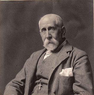
Edward Carlyon Eliot, was a British Colonial Service administrator.
The Japanese occupation of Nauru was the period of three years during which Nauru, a Pacific island which at that time was under Australian administration, was occupied by the Japanese military as part of its operations in the Pacific War during World War II. With the onset of the war, the islands that flanked Japan's South Seas possessions became of vital concern to Japanese Imperial General Headquarters, and in particular to the Imperial Navy, which was tasked with protecting Japan's outlying Pacific territories.
The Japanese occupation of the Gilbert Islands was the period in the history of Kiribati between 1941 and 1945 when Imperial Japanese forces occupied the Gilbert Islands during World War II, in the Pacific War theatre.
Katerina Teaiwa, is a Pacific scholar, artist and teacher of Banaban, I-Kiribati and African American heritage. Teaiwa is well known for her scholarly and artistic work that focuses on the history of British Phosphate Commissioners mining activity in the Pacific during the 1900s and the consequent displacement of Banabans. In 2022, she became the first Indigenous woman from the Pacific to win the Australian University Teacher of the Year award and be promoted to full professor at the Australia National University.
