Tittensor

Last updated
Tittensor
St Luke's Church - geograph.org.uk - 5236.jpg
St Luke's Church, Tittensor
Staffordshire UK location map.svg
Red pog.svg
Tittensor
Location within Staffordshire
Civil parish
District
Shire county
Region
Country England
Sovereign state United Kingdom
Post town Stoke-on-Trent
Postcode district ST12
Police Staffordshire
Fire Staffordshire
Ambulance West Midlands
UK Parliament
List of places
UK
England
Staffordshire
52°56′31″N2°11′20″W / 52.942°N 2.189°W / 52.942; -2.189

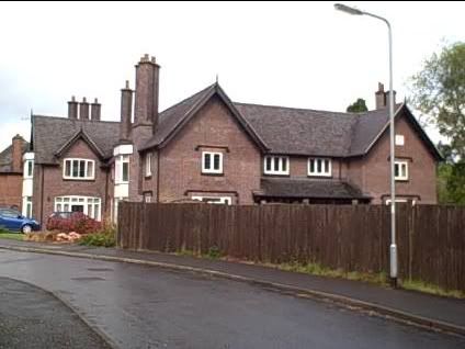
Tittensor village is located in Staffordshire, England, between Newcastle-under-Lyme and Stone. The population as taken at the 2011 census can be found under Swynnerton. The village consists of mostly 1960s housing as well as the few remaining houses from the 19th century. Historically Tittensor forms part of Stone parish. The Tittensor family [1] occupied a manor house which passed to the Gerrard family sometime before 1405. The house was destroyed and rebuilt several times over the centuries, and was finally demolished in 1834. Some of the materials were used to build St Luke's church in Tittensor which was constructed in 1880-81. The ruins of the manor house remained until they were finally demolished in the early 1960s.

Contents

History

It was originally mentioned in the Domesday Book and became part of the Trentham Estate of the Duke of Sutherland in the nineteenth century. The village was enlarged in the 1960s by a private estate, providing the majority of the houses that stand there today, including council owned houses. In 2002 Tittensor has been expanded by a new development on the site of Groundslow Hospital, [2] an old maternity hospital. Groundslow Villa was built in 1832 as a hunting lodge for the Duke of Sutherland when he lived at Trentham Park (the date can be seen on one of the walls) and in 1913 was sold and became a tuberculosis sanatorium as an annexe to the Staffordshire General Infirmary in Stafford.

In 1956 it was still a tuberculosis sanatorium, with separate men's and women's wards. In later years, certainly by 1960, the former women's TB building had become a 117-bed maternity hospital, until closure in 1983. [3] Camelot Court nursing home later opened in the administrative block of the former hospital in September 1985, while Groundslow Grange care home opened in October 1984 in the former nurses' accommodation, which had been built in 1949. It was run by Peter Ratchford and former Benny Hill girl Anne Bruzac. The residential care home closed in 1997, and by 2002 the adjacent former hospital was redeveloped into detached homes and terraces, while the Duke's former home was converted into 25 flats. [4]

Village hall

The village hall is located just off the main A34 along Winghouse Lane. [5]

The land of about one acre was given by conveyance dated 10 April 1956 made between Thomas Fortescue Crawshay Frost, the Honourable William Humble David Ward and Arthur Stephen Fuller (acting as the 'Sutherland Trustees') for the purpose of a Village Hall for the Benefit of the inhabitants of the Parish of Tittensor and the neighbourhood. This Land was originally part of the late Duke of Sutherland's estate left in trust on 13 June 1960 by Frederick Maitland Wright, Thomas Robert Copeland, Mary Clare Bassett and Harold Spilsbury.

The hall is used for meetings, lectures and classes, recreation and leisure with the object of improving the conditions of life for its residents. The opening of the hall was held on Saturday 7 July 1956 and was performed by Mrs Maitland Wright on behalf of her mother Mrs Frank Wedgwood who was in South Africa. She was one of the prime movers in the campaign for a village hall. The brick-built hall, costing £5,000, was designed and planned by Albert Homes an assistant Surveyor to the Stone Rural District Council, who lived next door to the hall. The committee had been trying to get a hall for some six years, after residents had begun to subscribe money after the First World War, some thirty years before.

An alcove extension to the width of the hall was in the planning from 1985 with the free work being undertaken by the Community Programme Agency the original scheme to cost £7,000 for materials. This turned out to become £21,260 and by 1990 the Community Programme Agency was disbanded and became the Employment Training Division. Meanwhile, extensions to the kitchen and toilets were completed.in 1990.

During 2003/4 a complete renovation was completed. This included new ceiling tiles and Led lighting, replacement flooring in the alcove, passage and kitchen new chairs, tables and curtains. To complete the project the hall was completely redecorated. A child's play area project was completed adjacent to the village hall using £20,000 from Stafford Borough Council Section 106 funds (resulting from housing development at Groundslow) plus a grant from the Staffordshire Environmental Fund (landfill tax) of £30,000. The grants were made to Swynnerton Parish Council and the land was also leased to them by the village hall. The council took the responsibility for ownership, maintenance and insurance.

In 2013 a defibrillator was sited on the outside wall of the hall. Donations were received from all the village groups, Bassetts and the parish council of £1,537. Training was given to two groups of residents.

Facilities

In the village there is St Luke's Church, [6] a village shop and post office, a village hall, a car sales garage and a wine shop. A converted private house in the village is home to a small community of adults with learning difficulties, some of whom attend the church regularly.

Transport

It lies on the A34 road which is dual carriageway through the village, with a 40 mph speed limit and speed cameras. It is well served by regular bus service [7] (number 101) north to Trentham, Newcastle-under-Lyme and Stoke-on-Trent and south to Stone and Stafford.

There is also a freight transport company. [8]

The Winghouse public house closed in 2012 and houses have been built on the site. The village hall is a very popular venue for local organisations. It has a bowling green and in 2013 a new child's play area – with land leased to Swynnerton Parish Council who maintain the project.

Education

There is a primary school which has close links with the church, and some church members serve on the board of governors. There are about 60 children in the school at present, some coming from outside the village. Daily coaches from the village offer transport to middle and high schools serving the Stone district.

Leisure

A woodland walk in Tittensor Tittensor Chase - geograph.org.uk - 291312.jpg
A woodland walk in Tittensor

The village has a bowling green with an active club and also has a well supported Gardening Guild that hosts its own show each summer. The 'Green Drive' is a lake and woodland area, often used by dog walkers, located next to the village, and once home to a children's playground which has since been removed. The area offers a large lake attracting anglers, as well as nature sightings for visitors. Wildlife includes kingfishers and wildcats.

Nearby locations

See also

Related Research Articles

<span class="mw-page-title-main">Duke of Sutherland</span> Title in the peerage of the United Kingdom

Duke of Sutherland is a title in the Peerage of the United Kingdom which was created by William IV in 1833 for George Leveson-Gower, 2nd Marquess of Stafford. A series of marriages to heiresses by members of the Leveson-Gower family made the dukes of Sutherland one of the richest landowning families in the United Kingdom. The title remained in the Leveson-Gower family until the death of the 5th Duke of Sutherland in 1963, when it passed to the 5th Earl of Ellesmere from the Egerton family.

<span class="mw-page-title-main">Stone, Staffordshire</span> A Town in Staffordshire

Stone is a market town and civil parish in Staffordshire, England, situated approximately 7 miles north of the county town of Stafford, 7 miles south of Stoke-on-Trent, and 15 miles north of Rugeley. As a notable canal town, Stone is recognised for its rich history, originating from the early Bronze Age and continuing through the Industrial Revolution, with the introduction of the Trent and Mersey Canal shaping the town's development and local industry.

<span class="mw-page-title-main">History of Staffordshire</span> Aspect of history

Staffordshire is a landlocked county in the West Midlands of England. It adjoins Cheshire to the north west, Derbyshire and Leicestershire to the east, Warwickshire to the south east, West Midlands and Worcestershire to the south, and Shropshire to the west. The historic county of Staffordshire includes Wolverhampton, Walsall, and West Bromwich, these three being removed for administrative purposes in 1974 to the new West Midlands authority. The resulting administrative area of Staffordshire has a narrow southwards protrusion that runs west of West Midlands to the border of Worcestershire. The city of Stoke-on-Trent was removed from the admin area in the 1990s to form a unitary authority, but is still part of Staffordshire for ceremonial and traditional purposes.

<span class="mw-page-title-main">Trentham Estate</span>

The Trentham Estate, in the village of Trentham, is a visitor attraction located on the southern fringe of the city of Stoke-on-Trent in Staffordshire, United Kingdom.

<span class="mw-page-title-main">Stone (UK Parliament constituency)</span>

Stone is a constituency represented in the House of Commons of the UK Parliament since its 1997 recreation by Sir Bill Cash, a Conservative. On 9 June 2023, he announced his intention to stand down at the next general election.

<span class="mw-page-title-main">George Leveson-Gower, 1st Duke of Sutherland</span> English politician, diplomat and landowner

George Granville Leveson-Gower, 1st Duke of Sutherland KG, PC, known as Viscount Trentham from 1758 to 1786, as Earl Gower from 1786 to 1803 and as the Marquess of Stafford from 1803 to 1833, was an English politician, diplomat, landowner and patron of the arts from the Leveson-Gower family. He was the wealthiest man in Britain during the latter part of his life. He remains a controversial figure for his role in the Highland Clearances.

<span class="mw-page-title-main">George Sutherland-Leveson-Gower, 2nd Duke of Sutherland</span> English peer, MP and cricketer

George Granville Sutherland-Leveson-Gower, 2nd Duke of Sutherland, KG, styled Viscount Trentham until 1803, Earl Gower between 1803 and 1833 and Marquess of Stafford in 1833, was a British Whig MP and peer from the Leveson-Gower family.

<span class="mw-page-title-main">Barlaston</span> Human settlement in England

Barlaston is a village and civil parish in the borough of Stafford in the county of Staffordshire, England. It is roughly halfway between the city of Stoke-on-Trent and the small town of Stone. According to the 2001 census the population of the parish was 2,659, rising at the 2011 Census to 2,858.

<span class="mw-page-title-main">Trentham, Staffordshire</span> Human settlement in England

Trentham is a suburb of the city of Stoke-on-Trent in North Staffordshire, England, south-west of the city centre and south of the neighbouring town of Newcastle-under-Lyme. It is separated from the main urban area by open space and by the Trent and Mersey Canal and the River Trent, giving it the feel of a village.

<span class="mw-page-title-main">Swynnerton</span> Human settlement in England

Swynnerton is a village and civil parish in Staffordshire, England. It lies in the Borough of Stafford, and at the 2001 census had a population of 4,233, increasing to 4,453 at the 2011 Census.

Yarnfield is a village in Staffordshire, England. Population details as taken in the 2011 census can be found under Swynnerton It is considered part of historic Stone, and is near to other historic locations such as Eccleshall and Swynnerton.

<span class="mw-page-title-main">Clayton, Staffordshire</span> Human settlement in England

Clayton is a suburb and a ward in the Newcastle-under-Lyme district, in the county of Staffordshire, England.

<span class="mw-page-title-main">Acton, Staffordshire</span> Hamlet in Staffordshire, England

Acton is a hamlet in the Borough of Newcastle-under-Lyme, Staffordshire.

Stone Rural District was a rural district in Staffordshire, England. It was created in 1894 and abolished by virtue of the Local Government Act 1972 in 1974. It was originally formed of the civil parishes of Barlaston, Chebsey, Cold Norton, Eccleshall, Milwich, Sandon, Standon, Stone Rural, Swynnerton and Trentham. In 1897 two new civil parishes were added, Fulford and Hilderstone.

<span class="mw-page-title-main">Swynnerton Hall</span> Country house in Swynnerton, Staffordshire

Swynnerton Hall is an 18th-century country mansion house, the home of Lord Stafford, situated at Swynnerton near Stone, Staffordshire. It is a Grade I listed building.

Trentham Priory was a Christian priory in North Staffordshire, England, near the confluence between the young River Trent and two local streams, where the Trentham Estate is today.

<span class="mw-page-title-main">Standon, Staffordshire</span> Human settlement in England

Standon is a village and civil parish in the Stafford district, in the county of Staffordshire, England. Standon has a church called Church of All Saints and one school called All Saints C of E First School. In 2001 the population of the civil parish of Standon was 823, and in the 2011 census it had a population of 879.

Swynnerton is a civil parish in the Borough of Stafford, Staffordshire, England. It contains 62 listed buildings that are recorded in the National Heritage List for England. Of these, two are listed at Grade I, the highest of the three grades, six are at Grade II*, the middle grade, and the others are at Grade II, the lowest grade. The parish contains villages including Swynnerton, Tittensor, Yarnfield, and Hanchurch, and the surrounding area. In the parish is the Trentham Estate, the area around the former Trentham Hall, most of which has been demolished. The remains of the hall, associated structures, and buildings in the garden and surrounding park are listed. Outside the estate, most of the listed buildings are houses and associated structures, cottages, farmhouses and farm buildings, the earlier of which are timber framed. The other listed buildings include churches and a chapel, items in churchyards, a country house and associated structures, buildings associated with a pumping station, bridges, and war memorials.

References

  1. "TITTENSOR One-Name Study Homepage". tittensor.com.
  2. "Archaeology Data Service: myADS" (PDF). archaeologydataservice.ac.uk.
  3. "Midlands Heritage Forum". Midlands Heritage Forum.
  4. Photos of Grounslow slow to load Retrieved Jan 2017
  5. TITTENSOR VILLAGE HALL website History page retrieved Jan 2017
  6. Website for St Luke's Church retrieved Jan 2017
  7. Potteries First website Route 101 page retrieved Jan 2017
  8. Bassetts website retrieved Jan 2017

52°56′31″N2°11′20″W / 52.942°N 2.189°W / 52.942; -2.189