
Ghazipur, is a city in the state of Uttar Pradesh, India. Ghazipur city is the administrative headquarters of the Ghazipur district, one of the four districts that form the Varanasi division of Uttar Pradesh. It is located on the Ganges (Ganga) River near the border with Bihar state, about 40 miles (65 km) northeast of Varanasi (Benares).The city of Ghazipur also constitutes one of the seven distinct tehsils, or subdivisions, of the Ghazipur district.

Ghazipur district is a district of Uttar Pradesh state in northern India. The city of Ghazipur is the district headquarters. The district is part of Varanasi Division. The region of Ghazipur is famous mainly for the production of its unique rose-scented Spray called Gulab Jal, and for the tomb of the Governor General of British India, Lord Cornwallis, who died here. His tomb is situated in Western part of City, and is conserved by Archaeological Survey of India.

Dildarnagar Fatehpur Bazar is a neighbourhood of Dildarnagar, located in the Ghazipur district of the Indian state of Uttar Pradesh. It is situated on the banks of the River Ganges and is approximately 35 kilometers from the city of Ghazipur. The town is known for its historical and cultural significance, and it has several temples, mosques, and other landmarks that attract visitors from different parts of India. Dildarnagar is also an important commercial center and has a bustling market where locals and visitors can purchase a variety of goods and products. As of 2011 estimate the Population of Dildarnagar is 12855 and have an area of 1000 hectares.
Zamania is a town in the Indian state of Uttar Pradesh. Its municipal council is subordinate to the Ghazipur District. It is also the administrative head of Zamania tehsil,. It is also a very historical town, it derives its name from Ali Quli Khan Zaman, who was also known as Khan Zaman or Zaman Khan, he was a governor of Jaunpur, and Ghazipur during the time of Akbar.
Iraqi Biradri is a Sunni Muslim caste found chiefly in Ghazipur, Azamgarh, Ballia, Deoria and Gorakhpur districts of the eastern Uttar Pradesh in India. Iraqi Biradri is also referred to as Iraqi Shaikh.
Bahadurganj is a Municipality located in Zahurabad pargama of the Kasimabad Tehsil in Ghazipur district of Uttar Pradesh, India. Bahadurganj is located one the banks of Tamsa and Bhainsahi rivers.The town also served as the capital of Qasimabad estate.
Yusufpur Mohammadabad is a town and a Township in Ghazipur district in the Indian state of Uttar Pradesh. Haydaria village near Mohammadabad is the starting point of Purvanchal Expressway.
The Great Sherpur is a region or a pargana of 'Shankarwar Vansh' in the Mohammadabad tehsil of Ghazipur district in Uttar Pradesh. It consists of Sherpur Kalan, Sherpur Khurd, Semra, Firozpur, villages which were established by the descendants of Dullah Rai. It has population of 31322 as per 2011 Census.

Ghazipur Sadar is a constituency of the Uttar Pradesh Legislative Assembly covering the city of Ghazipur Sadar in the Ghazipur district of Uttar Pradesh, India.
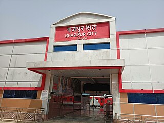
Ghazipur City railway station is located in Ghazipur City of Uttar Pradesh. It lies in the Malgodam Road. It comes under North Eastern Railway Zone (NER), Gorakhpur under Varanasi division. The station is directly connected to major cities of India.
Suhwal is a village of Ghazipur district under Reotipur block. It is situated on Ghazipur to Buxar Road 8 km (5 mi) from Ghazipur City. Its population is 10,814. The Village is quite old. It has its own local administration under the Panchayati Raj system, with Gram Pradhan as head of local administration. There are two Government Secondary Schools, three Government Primary Schools and some privately run Schools. There is a small permanent Market in the western side of the Village and also a weekly Market. Suhwal is a center of Shopping and Primary Education for many other small villages situated on its fringe.
Usia is a village in Kamsaar, Uttar Pradesh, India. It is located southeast of Ghazipur and east of Dildarnagar, near the Bihar State border. The village has a population of 24,786 residents living in 3,471 households. Usia is approximately 7 km from Dildarnagar. Around 8500 Kamsar Pathans lived here as of 2011.
Kusi is a village of Kamsaar in Ghazipur district in the Indian state of Uttar Pradesh. The village has also Jama masjid Kusi. The nearest railway station is Dildar nagar. As of 2011 census the main population of the village lived in an area of 62 acres and had 796 households. The family of Kusi were one of the largest zamindars of Ghazipur and their zamindari was known as Kusi Kusi zamindari it became a Zamindari chieftaincy in year 1858 which was ruled by the family of Kusi and Bhaksi, it had 15 villages with an area of 94 km² in year 1901.

Saraila is a village in Kamsaar in the Indian state of Uttar Pradesh.Saraila is a village in Seorai Tehsil in Ghazipur District of Uttar Pradesh, India. It belongs to Varanasi Division. It is located 30 km to the south of District headquarters Ghazipur. 11 km from Seorai. 372 km from State capital Lucknow. The village was also a part of Daudpur Estate which had its capital at Dewaitha during Mughal and early British era.
Pakhanpura is a village situated in Bhawarnkol Block in Ghazipur district of Uttar Pradesh, India. The village lies 29 km east of Ghazipur, 18 km (11 mi) from Bhawarnkol, and 373 km (232 mi) from the State capital Lucknow. The village has one post office. The population of the village is approximately 20,000 people.
Bhimapar is a village and a Gram panchayat in Ghazipur district of Uttar Pradesh, India. Bhimapar is a developing and new face town. It is 57 km from Varanasi and 57 km from Ghazipur.
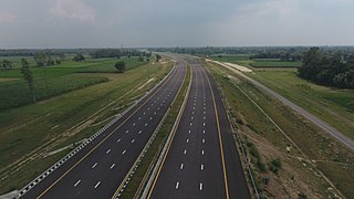
Purvanchal Expressway is a 340.8 km long, 6-lane wide access-controlled expressway in the state of Uttar Pradesh, India. The expressway connects Chand Saray village near Gosainganj in Lucknow district with Haydaria village on NH-31 in Ghazipur district. It is developed by the Uttar Pradesh Expressways Industrial Development Authority (UPEIDA). The Purvanchal Expressway has a 3.2 km long airstrip at Akhalkiri Karwat village near Kurebhar in Sultanpur district for emergency landing of aircraft. The construction work was started by the UPEIDA on 10 October 2018 and was inaugurated and opened to the public on 16 November 2021.
Bhurkura is a village in Jakhanian tehsil of Ghazipur district. of Uttar Pradesh, India. It belongs to Varanasi Division.
Dewaitha is a village of Dildarnagar Kamsar,in Zamania tehsil of Ghazipur, India, located on the banks of the Karmanasa River and it's tributary Eknaiya, The village had a population of 7,104 as of the 2011 Census of India. The place is inhabited by Kamsar Pathans..
