Related Research Articles

The Cook Islands is a self-governing island country in the South Pacific Ocean in free association with New Zealand. It comprises 15 islands whose total land area is 240 square kilometres (93 sq mi). The Cook Islands' Exclusive Economic Zone (EEZ) covers 1,960,027 square kilometres (756,771 sq mi) of ocean.

Auraka is a locality in the Keia district, on the western side of the island of Mangaia in the Cook Islands. The Keia district contains at least two ancient burial caves, Kauvava and Piri Te Umeume, which were accessed by diagonal descents through boulder-strewn roof collapses from the top of the makatea, the limestone cliffs that form a concentric ring around the central basalt core of the island. Gill, an early source for the mythology of Mangaia, noted a cave in Keia named Auraka, with one of its two entrances named Kauvava (1876a:71–79). However, according to Anton and Steadman, Gill's "description of the physical features of this cave does not match that of the cave currently known as Kauvava". Gill describes Auraka as a cave which is the 'last resting-place of the dead'.

In Cook Islands mythology, Avatea was a lunar deity and the father of gods and men in Mangaian myth of origin. His eyes were thought to be the Sun and the Moon; he was also known as the god of light.
In the mythology of Mangaia in the Cook Islands, Moko is a wily character and grandfather of the heroic Ngaru.
Ngaru is a mythological hero from Avaiki (Hawaiki) in the mythology of Mangaia in the Cook Islands. Ngaru's mother was Vaiare and his grandfather the great lizard Moko. His wife was the beautiful Tongatea. To prove his prowess, he battles Tikokura and the shark Tumuitearetoka, who he outwits with the aid of Moko. he later descends to the underworld and returns to the land of the living where he subsequently defeats the sky fairies and Amai-te-rangi, a sky demon.
Mangaia is the most southerly of the Cook Islands and the second largest, after Rarotonga. It is a roughly circular island, with an area of 51.8 square kilometres (20.0 sq mi), 203 kilometres (126 mi) from Rarotonga. Originally heavily populated, Mangaia's population has dropped by 75% in the last 50 years.

Atiu, also known as Enuamanu, is an island of the Cook Islands archipelago, lying in the central-southern Pacific Ocean. Part of the Nga-pu-Toru, it is 214 km (133 mi) northeast of Rarotonga. The island's population has dropped by two-thirds in the last 50 years.
Cook Islands Cricket Association is the official governing body of the sport of cricket in Cook Islands. Its current headquarters is in Rarotonga, Cook Islands. Cook Islands Cricket Association is Cook Islands's representative at the International Cricket Council and is an affiliate member and has been a member of that body since 2000. It is also a member of the East Asia-Pacific Cricket Council. Cricket in the Cook Islands has been around for over a hundred years. The first official record of cricket is in 1910 with the registration of the Rarotonga Cricket Association, however photos pre date this to at least the late 19th century. In 2012 CICA was struck of the register. The CICA organises the Cook Islands men's and women's national teams.In 2017, became an associate member
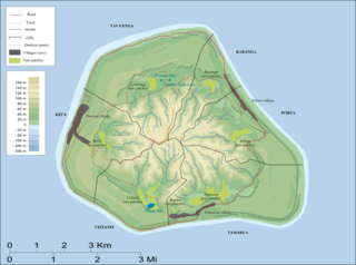
Kei'a is one of the six traditional districts of the island of Mangaia in the Cook Islands. It is located on the west side of the island, to the south of the District of Tava'enga and west of Veitatei. The district was traditionally divided into 6 tapere:
- Akaoro
- Tapuata
- Tongamarama
- Te-inati
- Rupetau-i-miri
- Rupetau-i-uta
Akava'ine is a Cook Islands Māori word which has come, since the 2000s, to refer to transgender people of Māori descent from the Cook Islands.

Tropical Cyclone Trina was a weak but destructive tropical cyclone in late 2001 which caused some of the worst flooding in the South Pacific island of Mangaia, Cook Islands, in nearly 50 years. Forming out of an upper-level low pressure system on November 29 near the island of Rarotonga, or roughly 1,470 mi (2,365 km) southeast of Fiji, Trina remained practically stationary as it meandered in the same general area for over a week. Due to unfavorable conditions for tropical cyclogenesis, the storm struggled to develop significant convection, preventing it from intensifying beyond 65 km/h (40 mph). After finally succumbing to wind shear on December 2, the system weakened to a tropical depression near Mangaia and dissipated several days later.
The Te Ipukarea Society (TIS) is an environmental non-government organisation based in the Cook Islands of Polynesia in the south-western Pacific Ocean. The original name was Taporoporo'anga Ipukarea Society, but was shortened a number of years ago to make it easier to pronounce. An approximate translation of the name from Cook Islands Māori is "looking after our heritage". It is the BirdLife International partner organisation for the Cook Islands, and also a member of the International Union for Conservation of Nature.
The Mangaia rail is an extinct species of flightless bird in the rail family, Rallidae.
The Mangaia crake is an extinct species of flightless bird in the rail family, Rallidae.
In Cook Islands mythology, Tumu-te-ana-oa was the female personification of Echo. She was the fourth child of Vari, the primordial mother goddess. Both her name and the land she occupied had to do with the production of echoes. Her name means "the cause (tumu) of the call or voice (oa) heard from caves (ana)". The term oa is used by people when calling out to evoke an echo. Her land was Te Parae-tea, which Gill translates, "The-hollow-gray-rocks". Mamae gives no more detail, but Gill recounts that Tumu-te-ana-oa frequented the caves of Mangaia, where she was seen by Rangi, one of the first inhabitants. The cave in which she was first seen was Aitu-mamaoa.
The following is a list of all reported tropical cyclones within the South Pacific Ocean, to the east of 160°E, before 1900.

Ngatupuna Matepi was a Cook Islands politician. He served as a member of the Legislative Assembly from 1958 until his death, had two spells in the cabinet between 1962 and 1965, and became the first official Leader of the Opposition in 1968.

Homalium acuminatum, the Cook Islands homalium, is a species of tree in the willow family, Salicaceae. It is endemic to the Cook Islands, growing on the islands of Rarotonga, where it is known as mato, and Mangaia, where it is known as moto. It grows to a height of up to 20 m (66 ft). On Rarotonga it dominates steep mountain slopes. The IUCN Red List calls it the Rarotonga homalium and considers it endemic to Rarotonga, though the Cook Islands Biodiversity Database lists it as also present, but "uncommon" on Mangaia.

Severe Tropical Cyclone Peni was the first and only tropical cyclone to impact and cause significant damage to the Cook Islands in the 1990 South Pacific cyclone season. A shallow area of low-pressure began to develop near Rakahanga, an island in the Cook Island chain. The storm had also formed on the South Pacific convergence zone. The storm was first recognized on February 12, and had received tropical cyclone characteristics on the 13th. At 21:00 UTC, the storm was recognized as Tropical Cyclone Peni. The storm then took a path southwest towards the Cook Islands, Peni made a narrow turn and passed close to Aitutaki. Peni had gained hurricane status on the 15th, at 06:00 UTC. Peni had been able to keep hurricane characteristics until February 17, when it was downgraded to a storm, and soon, was declared extratropical. The name Peni was retired from the naming list.
References
- 1 2 Joanna C. Ellison (August 1994). "Caves and Speleogenesis of Mangaia, Cook Islands" (PDF). National Museum of Natural History. Retrieved 31 July 2020.
- ↑ Stanley, David. South Pacific Handbook. Moon Travel Handbooks. p. 351.
- ↑ Iliffe, Thomas. "Anchialine Caves and Cave Fauna of the South Pacific" (PDF).
| | This Cook Islands location article is a stub. You can help Wikipedia by expanding it. |