
Shitara is a town located in Kitashitara District, Aichi Prefecture, Japan. As of 1 October 2019, the town had an estimated population of 4,531 in 2,133 households, and a population density of 16.5 persons per km². The total area of the town was 273.94 square kilometres (105.77 sq mi).

Hukuntsi is a village in Kgalagadi District (Kalahari) in Botswana.
Mochudi is one of the larger villages in Botswana with a population of 44,815 people in 2011. It is situated in the Bakgatla tribal region, in Kgatleng District, about 37 km (23 mi) northeast of Gaborone. The village lies several kilometres from the main Gaborone–Francistown road, and can be accessed through a short turn at Pilane. Mochudi was settled by the Tswana people in 1871. The main attraction in Mochudi is the Phuthadikobo Museum which is perched at the top of a hill and holds a rich history of Bakgatla tribe and Batswana in general
Molepolole is a large village in Kweneng District, Botswana.
Francistown is the second largest city in Botswana, with a population of about 100,079 and 150,800 inhabitants for its agglomeration at the 2011 census. and often described as the "Capital of the North". It is located in eastern Botswana, about 400 kilometres (250 mi) north-northeast from the capital, Gaborone. Francistown is located at the confluence of the Tati and Inchwe rivers, and near the Shashe River and 90 kilometres from the international border with Zimbabwe. Francistown was the centre of southern Africa's first gold rush and is still surrounded by old and abandoned mines. The City of Francistown is an administrative district, separated from North-East District. It is administered by Francistown City Council.

Education in Botswana is provided by public schools and private schools. Education in Botswana is governed by the Ministries of Basic Education. and Tertiary, Research Science and Technology
Bobonong is a town in the Central District of Botswana 80 km from Selibe Phikwe town. Bobonong has a population of around 19,000. The Babirwa tribe can be found in this town. The Botswana Pink semi-precious stones can be found in Bobonong region. The Babirwa are known for harvesting the mophane worm. The locals refer to the town as Bobcity or formerly Lekgarapeng, which was derived from the stoney landscape of the town.
Letlhakane is a village in the Central District of Botswana. Letlhakane is the headquarters of the Boteti sub-district. It is located south of Mmatshumo and the population of the village was 22,911 in 2011 census.

Thamaga is a large village located in the Kweneng District of Botswana and about 40 km west of the capital city Gaborone. It is home to 19,547 inhabitants at the 2011 census. It is becoming year by year like a suburb part of the Gaborone agglomeration.
Tutume is a large Bakalanga village located in the Central District of Botswana, about 50 km from the Zimbabwe border gate at Maitengwe. The nearest city is Francistown, about 100 km away. The village is a sub district headquarters and has a population of 13,000.It is made up of wards: Madikwe, Selolwane, Thini and Magapatona. In each ward there is a headman and his advisers in the kgotla. The main kgotla is located in Madikwe ward near Tutume Central Primary School. The village was named after the river "TUTUME", in Kalanga they will say "gwizi go Tutuma", meaning that the river was overflowing.
Mosu is a village in Central District of Botswana. The village is located to the south of Sua Pan – the eastern half of Makgadikgadi Pan – and it has a primary school and a junior secondary school namely Mosu Primary School and Makgadikgadi Junior Secondary School respectively. The population was 1,792 in 2011 census. Mosu is also the gateway to Makgadikgadi plains. Village is located on the foot of a hilly landform, exposing the village's terrain to massive soil erosion.
Tshokwe is a village in Central District of Botswana. The village is located south-east of Francistown, near the border with Zimbabwe, and it has a primary school. The population was 897 according to the 2001 census.
Maunatlala is a village in Central District of Botswana at the feet of the Tswapong Hills, near the Lotsane River. It is located 65 km (40 mi) east of Palapye and 60 km (37 mi) from the border with South Africa. The population was 4,364 in 2011 census. The village is the site of the Lotsane Dam, which started impounding in January 2012 and supplies drinking water as well as water for irrigation in a 250 hectares horticulture operation near Maunatlala.
Otse is a village in the South-East District of Botswana. It is located 60 km south of Gaborone, along the Gaborone–Lobatse road and close to the border with South Africa. This village is home to the Balete people who are related to those in Ramotswa, Gabane and Mogobane. The population was 7,636 in 2011 census.
Letlhakeng or Lethakeng is an urban village in Kweneng District of Botswana. The village is located 75 km north-west of Molepolole. The population of Letlhakeng was 7,229 in the 2011 census.
Lejwana, Botswana is a small village in the Republic of Botswana in Africa. It is situated in the Southern District of Botswana. It lies between the coordinates 25°24'23S and 25°32'27E. It is situated between the villages of Gathwane, Pitsane, Kgoro and Digawana. Lejwana is about 30 km from Lobatse and about 100 km by road from the capital Gaborone.
Molapowabojang is a village in the Southern District of Botswana, Located between Lobatse and Kanye, about 15 km North-West of Lobatse. With a population of about 7,520. This village falls under an administration of the Southern District Council which is headquartered in Kanye.
Mmadinare is a village that is located in the Central District of Botswana, 15 kilometers from Selibe Phikwe. The village is slowly growing into a town, with a population estimate of about 13 000 people of different tribes including Bangwato, Batalaote, Babirwa, and others. Mmadinare is located in the center of hills; like other villages in Southern Africa it was started during wars and hills were used as a form of protection from enemies, as they were able to see them from a distance.
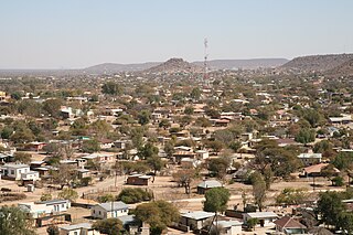
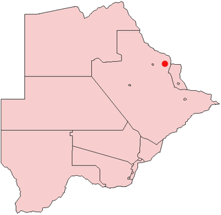
Makaleng is a village in the North-East district of Botswana, roughly 60km from Francistown.
