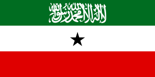
Somaliland, officially the Republic of Somaliland, is an unrecognised state in the Horn of Africa, recognised internationally as a de jure autonomous region of Somalia. Its located on the southern coast of the Gulf of Aden. It is bordered by Djibouti to the northwest, Ethiopia to the south and west, and Somalia to the east. Its claimed territory has an area of 176,120 square kilometres (68,000 sq mi), with approximately 5.7 million residents as of 2021. The capital and largest city is Hargeisa. The government of Somaliland regards itself as the successor state to British Somaliland, which, as the briefly independent State of Somaliland, united from 1960 to 1991 with the Trust Territory of Somaliland to form the Somali Republic.
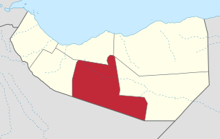
Togdheer is an administrative region (gobol) in central Somaliland. Togdheer is bordered by Maroodi Jeex to the west, Saaxil to the north, Sanaag to the northeast, Sool to the east and Ethiopia to the south. Its capital is Burao.

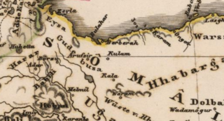
Burao, also spelt Bur'o or Bur'ao, is the capital of the Togdheer region and the second largest city in Somaliland. Burao was also the third largest city of Somalia and the site of the declaration of an independent Somaliland on 18 May 1991.
The Habar Yoonis alternatively spelled as Habr Yunis is a major clan part of the sub-clan Garhajis of the wider Isaaq. As descendants of Ismail bin Sheikh Isaaq, its members form a part of the wider Habar Magaadle confederation which constitutes the largest sub-clan of the Isaaq.

The Isaaq (Somali: Reer Sheekh Isxaaq, is an ethnic group in Somaliland. It is one of the major tribes in the Horn of Africa, with a large and densely populated traditional territories.
The Garhajis historically known as the Habar Gerhajis is a major clan of the wider Isaaq clan family. They are the traditional holders of the Isaaq Sultanate and Habr Yunis Sultanate since the 18th century. As descendants of Ismail bin Sheikh Isaaq, its members form a part of the Habar Magaadle confederation, and they constitute the largest sub-clan of the Isaaq. The Garhajis are divided into two major sub-clans: the Habr Yunis and Eidagale. They are traditionally nomadic pastoralists, merchants and skilled poets.
The Ogaden is one of the major Somali clans.
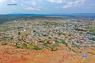
Sheikh, is a city in central Somaliland. Sheikh is the capital of the Sheikh district in the region/province Sahil. It lies at an altitude of some 1430 m in the Golis Mountains, roughly halfway between the larger cities of Berbera and Burao .
The broader Sheikh District has a total population of about 100,000 residents.
Burao District is a district of the Togdheer region in central Somaliland. Its capital lies at Burao.

Gaanlibah or Ga'an Libah is mountain range, archaeological site, and national park located in the Maroodi Jeex region of Somaliland. Nearby are the Golis Mountains. Its upper slopes are the source of the seasonal Togdheer river that flows through the city of Burao into the Nugaal Valley.
Ahmed Warsama, more commonly known as Haji Sudi was one of the leaders behind the Somali Dervish movement. He was also the movement's right-hand man and chief lieutenant till its demise in 1920. He is described as the Mullah's right hand in the earlier days of his rise. He hailed from the Adan Madoba sub-clan of the Habr Je'lo clan.
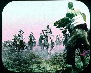
SultanNur Ahmed Aman, was a learned religious leader and the 5th Sultan of the Habr Yunis Sultanate and later also one of the leaders behind the Somali Dervish movement and revolt (1899–1920). He was the principal agitator rallying the followers of the Kob Fardod Tariqa behind his anti-French Roman Catholic Mission campaign that would become the cause of the Dervish uprising. He assisted in assembling men and arms and hosted the revolting tribesmen in his quarter at Burao in August 1899, declaring the Dervish rebellion. He fought and led the war throughout the years 1899–1904. He and his brother Geleh Ahmed were the main signatories of the Dervish peace treaty with the British, Ethiopians and Italian colonial powers on March 5, 1905, known as the Ilig Treaty or the Pestalozza agreement. Sultan Nur is entombed in a white-domed shrine in Taleh, the location of the largest Dervish forts and the capital of the Dervish from 1912 to 1920, a testimony to his contribution in creating the movement.
The Issa Musa or ‘Isa Musa is a northern Somali clan. Its members form a part of the Habr Awal clan of the Isaaq clan family. The Isa Musa are divided into four major sub-clans: Mohammed Issa, Adam Issa, Abokor Issa and Idarais Issa. The Isa Musa traditionally consists of coastal people, nomadic pastoralist and merchants. This clan are primarily settled in Somaliland, including Maroodi Jeex, Togdheer, Sahil, Ethiopia, as well as Kenya. The Issa Musse have produced many prominent Somali figures with the Undersecretary General of the United Nations Abdulrahim Abby Farah, the first Somali Prime Minister & second President of Somaliland Muhammad Haji Ibrahim Egal, and the second tallest man in the world Hussein Bisad.
Events of 2020 in Somaliland.
Sultan AwadDeria was a Somali ruler and the 4th Sultan of the Habr Yunis during the late nineteenth century.
The Somaliland Declaration of Independence was proclaimed on 18 May 1991 by Somali Sultans from the Isaaq, Dhulbahante, Issa, Gadabursi, Warsangali clans and the Somali National Movement.
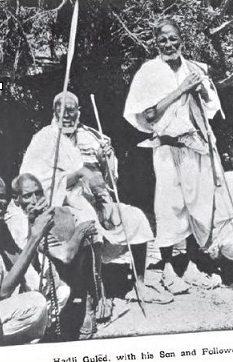
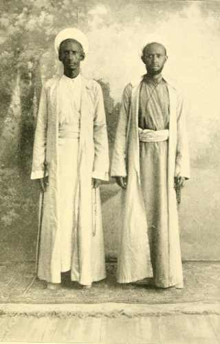
Guled Haji was a Somali sage and the Aqil or leader of the Baha Sugule branch of the powerful Rer Ainanshe Habr Yunis. The Rer Ainashe are the traditional rulers of the Habr Yunis Sultanate.
The Habr Yunis Sultanate was a Somali kingdom that ruled parts of the Horn of Africa during the 18th century. It spanned the territories of the Habr Yunis clan which is part of the wider Isaaq in modern day Somaliland and Ethiopia. The sultanate was governed by the Rer Ainanshe branch of the Habr Yunis clan.
The Reer Caynaashe also spelled Reer Caynaanshe are a royal Somali clan and the traditional rulers of the Habr Yunis. They divide into 17 major sub-clans that together form the Baha Ainanshe and Rer Sugulle, from the latter descend the rulers of the Habr Yunis Sultanate. They inhabit the Togdheer and Maroodi Jeex regions of Somaliland and the Daroor, Danot and Misraq Gashamo regions of Ethiopia

Cayn or Ayn is an administrative region that Puntland declared to be founded in the 2000s. However, the administrative division of Somaliland defines it as Buhoodle District in Togdheer, and Somaliland effectively controls it with the exception of Buhoodle district and some other parts. It is bordered by Togdheer to the west, Sool to the east, and Ethiopia to the south. Its capital is Buuhoodle. As an intra-46th meridian east territory, Buuhoodle has a tradition of being external to European colonial rule or convention.