Golis Mountains

Last updated
Golis
Foothills of Golis Mountain range.jpg
Foothills of the mountain range
Highest point
Elevation 1,371 m (4,498 ft) [1]
Coordinates 9°52′0″N44°55′0″E / 9.86667°N 44.91667°E / 9.86667; 44.91667
Geography
Somaliland relief location map.svg
Red triangle with thick white border.svg
Golis
Location of the Golis Mountains
Africa relief location map.jpg
Red triangle with thick white border.svg
Golis
Golis (Africa)
Location Togdheer & Maroodi Jeex & Saaxil Flag of Somaliland.svg  Somaliland

The Golis Mountains [2] (Golis range, Somali : Buuraleyda Golis) are a mountain range in Somaliland. [3] Also known as Qar Golis, they cut through the Togdheer region, [1] and end near the Gan Libah. [4]

Contents

The original meaning of Golis Mountains is a mountain range near Golis mountain, but since the Somali Civil War, the entire so-called Karkaar mountains are often referred to as the Golis Mountains.

Golis mountains in its original meaning

The mountain range near Sheikh is the Golis Mountains in its original sense, and also the Golis Mountains in today's narrower sense.

Area

In 1898, a map published in Two Recent Journeys in Northern Somaliland shows the Golis Range as being around 10 degrees north latitude and 44 degrees 30 minutes to 45 degrees 30 minutes east longitude. [5]

The North-Eastern British Somaliland of 1931 lists the area from 45°E to 46°E as the "Golis mountains" and the area near the border with Italian Somaliland as the "Al hills". [6]

A general survey of the Somaliland protectorate 1944-1950, a book published in 1951, refers to the combined topography of the Golis and Wogr mountains as the Golis-Wogr Range. The book says Golis Mountain is the name of a mountain east of Henweina [7] :157 and west of Sheikh. [7] :171 The town of Sheikh is located in the Sheikh Gorge between Golis Mountain to the west and Wogr Mountain to the east. [7] :101

In The World Atlas published by Soviet Union in 1967, the Golis Mountains are only shown around Golis mountain, and the area around Wogr mountain just east of Golis mountain is called Wogr Mountains. The mountain ranges east of the Wogr mountains have no names written on them. [8]

Jerato Pass

This range has a mountain pass known as the "Jerrato Pass". [4]

The Jerato or Gellato Pass, 1896 Jerato (Gellato) Pass (3948855536).jpg
The Jerato or Gellato Pass, 1896

Outlook

The eastern part of the Golis mountains is sandy, with many mimosa trees, and in some places Aloe and Sansevieria ehrenbergii . [9] :1

According to British Somaliland and Sokotra published in 1919, a large number of Zebu cattle were raised around the Golis Mountains for the purpose of taking Ghee. The meat and Ghee were exported to Aden in Yemen and the hides to the United States. [9] :52

Names of mountain ranges on the northern coast of the Somali Peninsula

The original Golis Mountains is the name of a mountain range at the northwestern edge of the Togdheer region. However, there is an intermittent east-west mountain range on the northern coast of the Somali Peninsula, which is now often referred to as the Golis Mountains. [10]

Especially after it was discovered that gold could be extracted near the village of Milho on the border of the Bari and Sanaag regions, pro-Islamic State militias and others made this location their base of operations, [11] and the term "Golis Mountains" is often used to refer to the mountain range near the border between the Bari and Sanaag regions. However, it is mainly after the Somali civil war that this terminology has been used.

Before Somali civil war

In the article North-Eastern British Somaliland written in 1931, it distinguishes between the "Golis Range" west of Mount Shimbiris and the Al Hills to the east. [6]

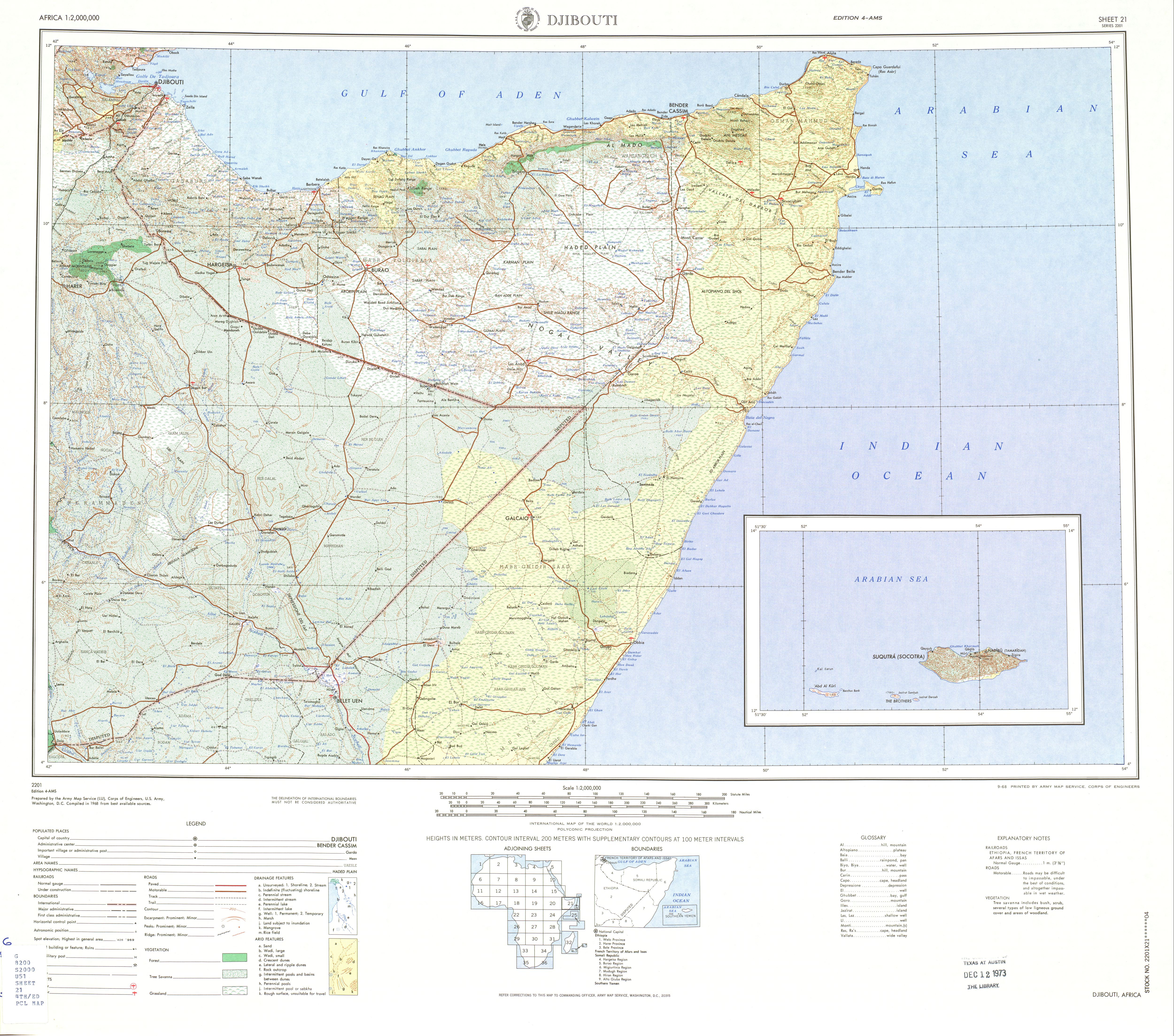
A map published by the US Army in 1968 lists the mountain range north of Sanaag as Al Mado; the Wagger Range is mentioned as a range near Sheikh, but the name Golis Range is not mentioned. [12]

The Historical Dictionary of SOMALIA, published in 1975, states "GOLIS MOUNTAINS. In the north-central area of the Republic. Mountain peaks reach an altitude of almost 8,000 feet." [13] :65

A map published in 1989, U.S. National Imagery and Mapping Agency, Series Y629, also shows the mountain range north of Sanaag as Buuraha Cal Madow. [14]

After Somali civil war

In the 1996 book Constructing colonial hegemony in the Somaliland protectorate, 1941-1960, the Golis Mountains are described as "for three hudred miles runs parallel to the coastal plain", [15] :36 this corresponds to Sheikh to Bosaso in a straight line.

In the web edition of the Encyclopædia Britannica written in 1998, the mountain range on the north coast of the Somali Peninsula is referred to as the Galgodon Highlands or Ogo Highlands. [16]

In 2002, ReliefWeb wrote that Gebi valley is located between Hadeed Plateau and Golis Mountains in Sanaag. [17]

According to the CULTURAL ORIENTATION SOMALI published by the Defense Language Institute in 2020, the Golis Mountains is another name for the Galgala Hills, part of the Karkaar mountain range. and the Ogo Highlands are south of the Karkaar mountain range. [18]

Golis Mountains in Sanaag

Since around 2009, the Golis Mountains appear exclusively as a place name in Sanaag, especially the mountains near Galgala on the eastern edge. Both Al-Shabaab and the Islamic State (ISIS) operate from this mountain range and are fighting for territorial control.

Recent History

In 2009, the Golis Mountains experienced a highly religious insurgency led by Mohamed Said Atom. [19] :9

In 2012, al-Shabaab replaced Atom as the leader of the Golis Mountains rebel group. [19] :8

In 2015, Islamic State began working in Puntland. [20]

In 2017, a large quantity of heavy ammunition was removed from African Union Mission to Somalia and Somali National Army bases. It is believed that these are still being stored at the Al-Shabaab base in the Gilis Mountains as of 2022. [21]

In 2019, al-Shabaab conducted a campaign of gold mining as a source of funding in the village of Milho near the Golis Mountains. [11]

In 2019, According to the Armed Conflict Location and Event Data Project, U.S. forces conducted six airstrikes against ISIS and one against al-Shabaab in the Golis Mountains, killing a total of 32 people. [22]

In August 2021, the Islamic State based in the Golis Mountains occupies Balidhidin in the Bari region. [20]

In March 2022, Puntland forces kill several al-Shabaab soldiers in the Dhagah-dhaabur and Habar-hagoogan hills of the Golis range. [23]

See also

Related Research Articles

<span class="mw-page-title-main">Puntland</span> Federal state in northeastern Somalia

Puntland, officially the Puntland State of Somalia, is a Federal Member State in northeastern Somalia. The capital city is the city of Garoowe in the Nugal region, and its leaders declared the territory an autonomous state in 1998. Puntland had a population of 4,334,633 in 2016. Geographically to the west, Puntland lays claim to the intra-46th meridian territories that were outside European colonial rule during parts of the Scramble for Africa period.

<span class="mw-page-title-main">States and regions of Somalia</span>

Somalia is a federal republic consisting of six federal states, Puntland, Somaliland, Jubaland, Galmudug, Khaatumo, K.g Somalia and Hirshaabelle and one interim administration. Somalia is further subdivided into 18 administrative regions, which are in turn subdivided into districts. One region, Banaadir, is not part of any state.

<span class="mw-page-title-main">Galgala</span> Place in Somalia

Galgala is a town in Bari region of Somalia. The town has ancient markings of religious symbols and crosses and ancient remains of a cairns which commonly found in Sanaag and Bari, Somalia regions.

<span class="mw-page-title-main">Qardho</span> City in Puntland, Somalia

Qardho, also known as Gardo, is a city in the northeastern Bari region of Somalia, a district within the autonomous state of Puntland.

Karkaar is a mountain range which ranges from Somalia's northwestern border with Ethiopia, until Cape Guardafui. It is also an administrative region defined by the autonomous Puntland state. The territory occupies the south of what has traditionally been the Bari region of Somalia, and generally lies south of the Karkaar mountain range.

<span class="mw-page-title-main">Badhan, Sanaag</span> City in Sanaag, Somalia Puntland

Badhan, also known as Baran is a city in the Sanaag region of Puntland state of Somalia.

<span class="mw-page-title-main">Puntland–Somaliland dispute</span> Territorial dispute in the Horn of Africa

The Puntland–Somaliland dispute is a territorial dispute over the provinces of Sool, Sanaag and the Buuhoodle district of Togdheer region between the self-declared Republic of Somaliland and the Puntland state of Somalia.

<span class="mw-page-title-main">Yubbe</span> A town in Somaliland

Yubbe is a town in the Sanaag, Puntland of Somalia. There is a Puntland military base.

<span class="mw-page-title-main">Hadaftimo</span> Town in Sanaag

Hadaftimo is a historic town in the eastern Sanaag region. It is home to several archaeological sites and ancient buildings. There is a Puntland military base.

Majiyohan, is a town in the northeastern Bari region of Somalia. Situated in the autonomous Puntland region. It is located at the northern foothills of the eastern end of the Galgala Mountains, which extend from east to west. It is mainly inhabited by the Dubays branch of the Warsangali clan.

<span class="mw-page-title-main">Buuhoodle</span> City in Khatumo

Buuhoodle, also known as Bohotle, is the largest city in the togdheer region of Somalia. It serves as a significant border town for the movement of goods between Somalia and the Somali Region of Ethiopia. The surrounding district is rich in livestock with growing agricultural activities.

<span class="mw-page-title-main">El Ayo</span> Town in Sanaag, Puntland

El Ayo, also known as El Ayum, is a coastal town in the eastern Sanaag region of puntland.

<span class="mw-page-title-main">Outline of Puntland</span> Overview of and topical guide to Puntland

Puntland, officially the Puntland State of Somalia, is a federal member state in north-eastern Somalia. The capital of Puntland is Garowe.

<span class="mw-page-title-main">Galgala campaign</span>

The Galgala campaign was a military campaign autonomous Puntland region of Somalia, that took place periodically from 8 August until 1 October 2014. It was aimed at re-gaining control of the Galgala hills, which had fallen in hands of al-Qaeda-linked al-Shabaab commander Sheikh Mohamed Said Atom and his militia.

<span class="mw-page-title-main">Mohamed Said Atom</span>

Sheikh Mohamed Said Atom is a Somali arms-smuggler, faction leader and al-Shabaab commander. On 7 June 2014, Atom surrendered to the Somali government.

<span class="mw-page-title-main">Ogo Mountains</span> Mountain range in Somaliland

The Ogo Mountains, also known as the Galgodon Highlands, are a mountain range in Somaliland. They cross the Sanaag and Togdheer regions. With a mean peak height of 2,450 m (8,040 ft), the ecology of this landform is semi-desert.

<span class="mw-page-title-main">Fiqifuliye</span> Town in Khatumo

Fiqifuliye is a town in the Fiqifuliye District of Sanaag region of the SSC-Khatumo State. Inhabited by the Ugaadhyahan specifically Nalaye Axmed - Bihina Caraale sub clan.

Af Urur is a village in the Puntland region of Somalia, located on the Golis Mountains, somewhat far from Bosaso, but its exact location is not known. The settlement is placed at a strategically important location, and has thus become strongly contested during the Somali Civil War. One of the most prominent clans in the village are the Tiinle.

<span class="mw-page-title-main">Battle of Af Urur</span>

The Battle of Af Urur took place on 8 June 2017, when al-Shabaab militants attacked and overran the military base and village of Af Urur in Puntland, killing many soldiers of the Puntland Security Force. It was the deadliest terrorist attack of any militant group in Puntland since the autonomous state's foundation in 1998.

Cayn or Ayn is an administrative region that Puntland unilaterally declared to be established in the 2000s. However, there is Somaliland between Cayn and Puntland, and they do not directly border each other. Somaliland has legally designated this area as its territory as Buhoodle District. SSC-Khatumo, which declared its secession from Somaliland in 2023, claims the territories of Sanaag, Sool, and Cayn, as its name implies, and effectively controls Buuhoodle.

References

  1. 1 2 "Golis Range, Somaliland". Getamap. Retrieved 23 June 2013.
  2. Abdullahi, Mohamed Diriye (2001). Culture and customs of Somaliland . Greenwood. ISBN   978-0-313-31333-2.
  3. Hoehne, Markus Virgil (2014). "Resource conflict and militant Islamism in the Golis Mountains in northern Somalia (2006–2013)". Review of African Political Economy. 41 (141): 358–373. doi:10.1080/03056244.2014.901945. S2CID   145703040.
  4. 1 2 Pease, A. E. (1913). "IV: Of dangerous game". The Book of the Lion. London: John Murray. pp. 46−68.
  5. F. B. Parkinson (January 1898). "Two Recent Journeys in Northern Somaliland". The Geographical Journal. 11 (1): 15–48. doi:10.2307/1774849. JSTOR   1774849 . Retrieved 2023-02-05.
  6. 1 2 Collenette, C. L. (1931). "North-Eastern British Somaliland" . Retrieved 2023-04-29.
  7. 1 2 3 John Anthony Hunt (1951). "A general survey of the Somaliland protectorate 1944-1950" . Retrieved 2021-09-25.
  8. USSR (1967). "170-171. Africa, Equatorial. The World Atlas" . Retrieved 2022-12-25.
  9. 1 2 Mohamed Osman Omar (2009). The scramble in the Horn of Africa. History of Somalia (1827-1977). ISBN   9781874209638 . Retrieved 2021-11-25.
  10. "Villagers: US Drone Strike in Somalia Kills Frankincense Collectors". VOA. 2019-10-27. Retrieved 2023-05-02.
  11. 1 2 "Getting a grip on Somalia's gold rush in Milxo". Hiiraan online. 2022-11-19. Retrieved 2023-05-02.
  12. US Army (1968). "Djibouti Sheet 21, Edition 4, AMS, 1968" . Retrieved 2023-05-02.
  13. Castagno, Margaret (1975). "Historical Dictionary of Somalia" . Retrieved 2023-04-29.
  14. U.S. National Imagery and Mapping Agency (1989). "Badhan (topographic) Sheet 9146, 1:100,000" . Retrieved 2023-05-02.
  15. Jama Mohamed (1996). "Constructing colonial hegemony in the Somaliland protectorate, 1941-1960" . Retrieved 2021-08-07.
  16. "Galgodon Highlands". Britannica. 1998-07-20. Retrieved 2023-05-02.
  17. "Monthly Food Security Report for Somalia Jan 2002". reliwfweb.int. 2002-02-07. Retrieved 2023-05-02.
  18. DEFENSE LANGUAGE INSTITUTE FOREIGN LANGUAGE CENTER TECHNOLOGY INTEGRATION (2020). "CULTURAL ORIENTATION SOMALI" (PDF). Retrieved 2023-05-02.
  19. 1 2 Omar S Mahmood (November 2019). "Overlapping claims by Somaliland and Puntland - The case of Sool and Sanaag" . Retrieved 2023-05-02.
  20. 1 2 "ISIS seizes key area in Somalia's Puntland after battle". Garowe Online. 2021-08-19. Retrieved 2023-05-02.
  21. "Bari". euaa. 2022. Retrieved 2023-05-02.
  22. LANDINFO (2020-04-07). "The security situation in northwestern Somalia (Somaliland)" (PDF). Retrieved 2023-05-02.
  23. "Puntland Forces kill 'several' Al-Shabaab fighters in Golis Mountains". Goobjoog News English. 2022-03-17. Retrieved 2023-05-02.