Outline of Somaliland

Last updated • 6 min readFrom Wikipedia, The Free Encyclopedia
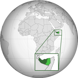
Map of Somaliland Somaliland (orthographic projection).svg
Map of Somaliland
An enlargeable map of Somaliland Map of Somaliland.svg
An enlargeable map of Somaliland
An enlargeable map of Somaliland Somaliland CIA map PL.jpg
An enlargeable map of Somaliland
Blank map of Somaliland Blank Somaliland Map.svg
Blank map of Somaliland

The following outline is provided as an overview and topical guide to Somaliland:

Contents

Somaliland is an internationally unrecognised country. [1] The government of Somaliland regards the territory as the successor state to the British Somaliland protectorate, which was independent for a few days in 1960 as the State of Somaliland, [2] [3] before voluntarily uniting with the Trust Territory of Somalia (the former Italian Somaliland) later the same week to form the Somali Republic. [2] [3] [4] [5] [6]

General reference

Geography of Somaliland

An enlargeable satellite image of Somaliland Somaliland sat.jpg
An enlargeable satellite image of Somaliland
Flag of Djibouti.svg  Djibouti 60 km
Flag of Ethiopia.svg  Ethiopia 766 km
Flag of Somalia.svg  Somalia 402 km
  • Coastline: 850,800 km

Environment of Somaliland

An enlargeable Geographic map of Somaliland Geographic map of Somaliland.svg
An enlargeable Geographic map of Somaliland

Natural geographic features of Somaliland

Ecoregions of Somaliland

List of ecoregions in Somaliland

Location of Somaliland

Administrative divisions of Somaliland

Administrative divisions of Somaliland

Regions of Somaliland
Map of Somaliland regions Somaliland regions.svg
Map of Somaliland regions

Regions of Somaliland

Administrative districts of Somaliland
Map of Somaliland districts Map of Somaliland districts.jpg
Map of Somaliland districts

The regions are divided into eighteen administrative districts.

Cities in Somaliland

The main cities and towns in Somaliland:

Demography of Somaliland

Demographics of Somaliland

Presidents of the Somaliland

Government and politics of Somaliland

Somaliland Presidential Palace - Qasriga Madaxtooyada JSL Somaliland Presidential Palace - Qasriga Madaxtooyada JSL.jpg
Somaliland Presidential Palace - Qasriga Madaxtooyada JSL
Dispute updated as of December 2016 Somaliland Puntland.png
Dispute updated as of December 2016

Politics of Somaliland

Branches of the government of Somaliland

Government of Somaliland

Executive branch of the government of Somaliland

Legislative branch of the government of Somaliland

Judicial branch of the government of Somaliland

Judiciary of Somaliland

Foreign relations of Somaliland

Foreign relations of Somaliland

International organization membership

Law and order in Somaliland

Judiciary of Somaliland

Military of Somaliland

Military of Somaliland

Local government in Somaliland

Local government in Somaliland

History of Somaliland

Agreements and Exchanges of Letters between the Government of the United Kingdom of Great Britain and Northern Ireland and the Government of Somaliland in connexion with the Attainment of Independence by Somaliland Independence Day State of Somaliland.png
Agreements and Exchanges of Letters between the Government of the United Kingdom of Great Britain and Northern Ireland and the Government of Somaliland in connexion with the Attainment of Independence by Somaliland

History of Somaliland

Culture of Somaliland

Culture of Somaliland

Art in Somaliland

Sports in Somaliland

Sports in Somaliland

Economy and infrastructure of Somaliland

Economy of Somaliland

Education in Somaliland

Education in Somaliland

See also

Gnome-globe.svg Wikimedia Atlas of Somaliland

Somaliland

Related Research Articles

<span class="mw-page-title-main">Somaliland</span> Unrecognised country in the Horn of Africa

Somaliland, officially the Republic of Somaliland, is an unrecognised country in the Horn of Africa. It is located in the southern coast of the Gulf of Aden and bordered by Djibouti to the northwest, Ethiopia to the south and west, and Somalia to the east. Its claimed territory has an area of 176,120 square kilometres (68,000 sq mi), with approximately 6.2 million people as of 2024. The capital and largest city is Hargeisa.

<span class="mw-page-title-main">Awdal</span> Region of Somaliland

Awdal is an administrative region (gobol) in western Somaliland. It was separated from Woqooyi Galbeed and became a province in 1984 and is the most northwesterly province of Somaliland. To the east it borders Maroodi Jeex and Sahil; to its north-west it borders Djibouti; to its south and south-west lies Ethiopia; and the Gulf of Aden to its north. The province has an estimated population of 1,010,566. The region comprises the four districts of Borama, the regional capital, Baki, Lughaya, and Zeila.

<span class="mw-page-title-main">Togdheer</span> Region of Somaliland

Togdheer is an administrative region (gobol) in central Somaliland. Togdheer is bordered by Maroodi Jeex to the west, Saaxil to the north, Sanaag to the northeast, Sool to the east and Ethiopia to the south. Its capital is Burao.

<span class="mw-page-title-main">Maroodi Jeex</span> Region of Somaliland

Marodi Jeh is an administrative region (gobol) in western Somaliland. It is the most populous region of the country. It is bordered by Awdal to the west, Sahil to the north, Togdheer to the east and Ethiopia to the south. Marodi Jeh was created by splitting the previously existing region (gobolka). In 2007 the region of Woqooyi Galbeed was renamed to Maroodi Jeex.

<span class="mw-page-title-main">Foreign relations of Somaliland</span>

Foreign relations of the Republic of Somaliland are the responsibility of the Ministry of Foreign Affairs of the Republic of Somaliland. The region's self-declaration of independence remains unrecognised by the international community.

<span class="mw-page-title-main">Economy of Somaliland</span>

The economy of Somaliland largely relies on primary production and agriculture, where livestock is the main export of the country, which it ships to neighbouring Djibouti and Ethiopia, as well as to Gulf states, such as UAE, Saudi Arabia and Oman. Somaliland has a GDP per capita of $1361 and a gross domestic product GDP of $7,583,000,000 as of 2024, most of which it receives in remittances from Somalis working abroad. The COVID-19 pandemic has restricted Somaliland's trade flows with decreased demand in the agriculture sector, a significant source of tax revenue.

<span class="mw-page-title-main">Regions of Somaliland</span>

The regions of Somaliland is divided into six administrative regions, Awdal, Sahil, Maroodi-Jeeh, Togdheer, Sanaag and Sool. These are in turn subdivided into twenty-two districts. Regions of Somaliland are the primary geographical divisions through which Somaliland is administered. A distinction is made between districts of grades A, B, C and D, with the classification being based on population, area, economy and production.

<span class="mw-page-title-main">Borama</span> City in Awdal, Somaliland

Borama is the largest city of the northwestern Awdal region of Somaliland. The commercial seat of the province, it is situated near the border with Ethiopia.

<span class="mw-page-title-main">Administrative divisions of Somalia</span>

Somalia is officially divided into 18 administrative regions. These are in turn subdivided into seventy-two districts

Over the course of the Somali Civil War, there have been many revolutionary movements and militia groups run by competing rebel leaders which have held de facto control over vast areas within Somalia.

<span class="mw-page-title-main">Habr Awal</span> Somali clan

The Awal, also contemporarily known as the Habr Awal, Subeer Awal, and alternately known as the Zubeyr Awal is one of the largest subclans of the wider Isaaq clan family, and is further divided into eight sub-clans of whom the two largest and most prominent are the Isamusa and Sa'ad Musa sub-clans. Its members form a part of the Habar Magadle confederation.

<span class="mw-page-title-main">Borama District</span> District in Awdal, Somaliland

Borama District is a district of the Awdal region in Somaliland.

<span class="mw-page-title-main">Muse Bihi Abdi</span> 5th president of Somaliland (2017-2024)

Musa Bihi Abdi is a Somaliland politician and former military officer who served as the 5th President of Somaliland from 2017 to 2024.

The following is an index of Somaliland-related articles.

Events of 2020 in Somaliland.

Events of 2019 in Somaliland.

Events in the year 2021 in Somaliland.

<span class="mw-page-title-main">Somaliland War of Independence</span> 1981–1991 conflict part of Somali Civil War

The Somaliland War of Independence was a rebellion waged by the Somali National Movement (SNM) against the ruling military junta in Somalia led by General Siad Barre lasting from its founding on 6 April 1981 and ended on 18 May 1991 when the SNM declared what was then northern Somalia independent as the Republic of Somaliland. The conflict served as the main theater of the larger Somali Rebellion that started in 1978. The conflict was in response to the harsh policies enacted by the Barre regime against the main clan family in Somaliland, the Isaaq, including a declaration of economic warfare on the clan-family. These harsh policies were put into effect shortly after the conclusion of the disastrous Ogaden War in 1978.

References

  1. "The Transitional Federal Charter of the Somali Republic" (PDF). University of Pretoria. 2004-02-01. Archived from the original (PDF) on 2008-12-18. Retrieved 2010-02-02. "The Somali Republic shall have the following boundaries. (a) North; Gulf of Aden. (b) North West; Djibouti. (c) West; Ethiopia. (d) South south-west; Kenya. (e) East; Indian Ocean."
  2. 1 2 "Somaliland Marks Independence After 73 Years of British Rule" (fee required). The New York Times. 1960-06-26. p. 6. Retrieved 2008-06-20.
  3. 1 2 "How Britain said farewell to its Empire". BBC News. 2010-07-23.
  4. Encyclopædia Britannica, The New Encyclopædia Britannica, (Encyclopædia Britannica: 2002), p.835
  5. "The dawn of the Somali nation-state in 1960". Buluugleey.com. Archived from the original on 2009-01-16. Retrieved 2009-02-25.{{cite web}}: CS1 maint: unfit URL (link)
  6. "The making of a Somalia state". Strategypage.com. 2006-08-09. Retrieved 2009-02-25.
  7. "The Transitional Federal Charter of the Somali Republic" (PDF). University of Pretoria. 2004-02-01. Archived from the original (PDF) on 2008-12-18. Retrieved 2010-02-02. "The Somali Republic shall have the following boundaries. (a) North; Gulf of Aden. (b) North West; Djibouti. (c) West; Ethiopia. (d) South south-west; Kenya. (e) East; Indian Ocean."
  8. Gettleman, Jeffrey (2009-06-02). "No Winner Seen in Somalia's Battle With Chaos". New York Times. Retrieved 2010-02-02.
  9. CIA - The World Factbook - Somalia
  10. "Agreements and Exchanges of Letters between the Government of the United Kingdom of Great Britain and Northern Ireland and the Government of Somaliland in connexion with the Attainment of Independence by Somaliland" (PDF). 1960-06-26. Archived from the original (PDF) on 2020-07-23.

Gnome-globe.svg Wikimedia Atlas of Somaliland