Togo, officially the Togolese Republic, is a country in West Africa bordered by Ghana to the west, Benin to the east and Burkina Faso to the north. The country extends south to the Gulf of Guinea, where its capital Lomé is located. Togo covers 57,000 square kilometres, making it one of the smallest countries in Africa, with a population of approximately 7.9 million, as well as one of the narrowest countries in the world with a width of less than 115 km (71 mi) between Ghana and its slightly larger eastern neighbor, Benin.

Vodun is practiced by the Fon people of Benin, and southern and central Togo; as well in Ghana, and Nigeria.
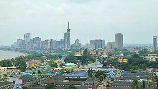
Lagos is the most populous city in Nigeria and the African continent. Lagos is a major financial centre for all of Africa and is the economic hub of Lagos State. The megacity has the fourth-highest GDP in Africa and houses one of the largest and busiest seaports on the continent. It is one of the fastest growing cities in the world.

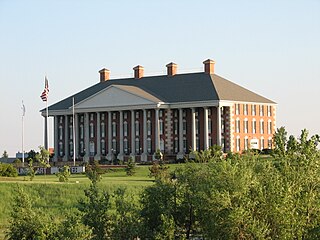
Devils Lake is a city in Ramsey County, North Dakota, United States. It is the county seat of Ramsey County. The population was 7,141 at the 2010 census. It is named after the nearby body of water called Devils Lake. The first house in Devils Lake was built in 1882. It was surveyed in 1883 and named Creelsburg and later Creel City, after the surveyor, Heber M. Creel. In 1884 it was renamed Devils Lake.
Watertown is a city in and the county seat of Codington County, South Dakota, United States. Watertown is home to the Redlin Art Center which houses many of the original art works produced by Terry Redlin, one of America's most popular wildlife artists. Watertown is located between Pelican Lake and Lake Kampeska, from which Redlin derived inspiration for his artwork.

Marshal-Admiral the Marquis Tōgō Heihachirō, served as a gensui or admiral of the fleet in the Imperial Japanese Navy and became one of Japan's greatest naval heroes. As Commander-in-Chief of the Combined Fleet during the Russo-Japanese War of 1904–1905, he successfully confined the Russian Pacific naval forces to Port Arthur before winning a decisive victory over a relieving fleet at Tsushima in May 1905. Western journalists called Tōgō "the Nelson of the East".

Delavan is a city in Walworth County, Wisconsin, United States. The population was 8,463 at the 2010 census. It is located 45 miles (72 km) southwest of Milwaukee. The city is located partially within the Town of Delavan but the two entities are politically independent.

Srinagar is the largest city and the summer capital of the Indian union territory of Jammu and Kashmir. It lies in the Kashmir Valley on the banks of the Jhelum River, a tributary of the Indus, and Dal and Anchar lakes. The city is known for its natural environment, gardens, waterfronts and houseboats. It is also known for traditional Kashmiri handicrafts like Kashmir shawls and also dried fruits. It is the northernmost city of India with over one million people.

Togoland was a German Empire protectorate in West Africa from 1884 to 1914, encompassing what is now the nation of Togo and most of what is now the Volta Region of Ghana, approximately 77,355 km2 in size. During the period known as the "Scramble for Africa", the colony was established in 1884 and was gradually extended inland.

Kpalimé is a city in the Plateaux Region of Togo, 120 km north of Lomé and 15 km from the border with Ghana. It is the administrative capital of Kloto Prefecture. Kpalimé has a population of 75,084, making it the fourth-biggest town in Togo, after Lomé, Sokodé and Kara. The town has a cathedral, a scientific lycée, and a post-office, as well as several banks, medical centres, pharmacies, cyber-cafés and petrol stations.

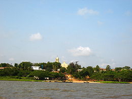
Aného, previously known as Anecho is a town in southeastern Togo, lying on the Gulf of Guinea near the border of Benin. Founded in the late 17th century by Ane peoples fleeing from Asante attacks in Elmina, Aného developed as a slave port and commercial centre. It was the capital of German Togoland from 1885 to 1887 and of the French occupation from 1914 to 1920. Aného remains an important intellectual centre for Togo, though it has not grown as rapidly as Togo’s other major cities. Pop. 25,400. It is situated 45 km east of the capital Lomé, between the Atlantic Ocean and Lake Togo in Maritime Region. Historically it was known as Little Popo and it had a Portuguese slave market. The nearby town of Zebe became the second capital of German Togoland in 1887. It gradually declined in importance after the capital was transferred to Lomé in 1897, a decline exacerbated by coastal erosion.
Togo is a country in West Africa.

Lake Togo(French: Lac Togo) is the largest part of a lagoon in Togo, separated from the Atlantic Ocean by a narrow coastal strip. It is shallow and a popular location for water sports. Towns on the lake's shore include Agbodrafo and Togoville. Transport on the lake is generally by pirogue.
The Ewe people are a West African ethnic group. The largest population of Ewe people is in Ghana, and the second largest population in Togo. They speak the Ewe language which belongs to the Niger-Congo Gbe family of languages. They are related to other speakers of Gbe languages such as the Fon, Gen, Phla Phera, and the Aja people of Togo and Benin.

The Mono River is the major river of eastern Togo.

Volta Region, is one of Ghana's sixteen administrative regions, with Ho designated as its capital. It is located west of Republic of Togo and to the east of Lake Volta. Divided into 25 administrative districts, the region is multi-ethnic and multilingual, including groups such as the Ewe, the Guan, and the Akan peoples. The Guan peoples include the Lolobi, Likpe, Akpafu, Buem, and Nkonya people, et al. This region was carved out of the Volta Region in December 2018 by the New Patriotic Party
German West Africa (Deutsch-Westafrika) was a rarely used designation for the German colonies in West Africa between 1884 and 1919. The term was normally used for the territories of Cameroon and Togo. German West Africa was not an administrative unit. However, in trade and in the vernacular the term was sometimes in use.

Tarakeswar is a city and a municipality in Hooghly district in the Indian state of West Bengal. It is also one of the police stations under Chandannagore subdivision. Tarakeswar is a place of pilgrimage and a centre of the Shaiva sect in West Bengal 58 kilometres (36 mi) away from Kolkata, Tarakeswar can be reached conveniently by train.

Dambai is a city in Ghana and the administrative capital of the newly created Oti Region.

The continent of Africa is one of the regions most rife with contemporary slavery. Slavery in Africa has a long history, within Africa since before historical records, but intensifying with the trans-Saharan and Indian Ocean slave trade and again with the trans-Atlantic slave trade; the demand for slaves created an entire series of kingdoms which existed in a state of perpetual warfare in order to generate the prisoners of war necessary for the lucrative export of slaves. These patterns have persisted into the colonial period during the late 19th and early 20th century. Although the colonial authorities attempted to suppress slavery from about 1900, this had very limited success, and after decolonization, slavery continues in many parts of Africa despite being technically illegal.