Related Research Articles

Issaquena County is a county located in the U.S. state of Mississippi. As of the 2010 census, the population was 1,406, making it the least populous county in the United States east of the Mississippi River. Its county seat is Mayersville. With a per-capita income of $18,598, Issaquena County is the poorest county in the United States.

Bolivar County is a county located on the western border of the U.S. state of Mississippi. As of the 2010 census, the population was 34,145. Its county seats are Rosedale and Cleveland. The county is named in honor of Simón Bolívar, early 19th-century leader of the liberation of several South American colonies from Spain.

Des Allemands is an unincorporated community and census-designated place (CDP) in Lafourche and St. Charles parishes in the southeastern part of the U.S. state of Louisiana. The population was 2,505 at the 2010 census. The town, known as the "Catfish Capital of the Universe", is along the Bayou des Allemands, which is the boundary of Lafourche and St. Charles parishes. Lac des Allemands is located northwest of the town. The ZIP code for Des Allemands is 70030.
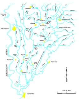
The Yazoo River is a river in the U.S. states of Louisiana and Mississippi. It is considered by some to mark the southern boundary of what is called the Mississippi Delta, a broad floodplain that was cultivated for cotton plantations before the American Civil War. It has continued to be devoted to large-scale agriculture.
The Gulf Intracoastal Waterway is the portion of the Intracoastal Waterway located along the Gulf Coast of the United States. It is a navigable inland waterway running approximately 1,050 mi (1,690 km) from Carrabelle, Florida, to Brownsville, Texas.
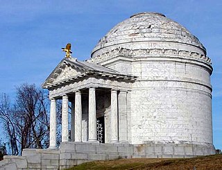
Vicksburg National Military Park preserves the site of the American Civil War Battle of Vicksburg, waged from March 29 to July 4, 1863. The park, located in Vicksburg, Mississippi, also commemorates the greater Vicksburg Campaign which led up to the battle. Reconstructed forts and trenches evoke memories of the 47-day siege that ended in the surrender of the city. Victory here and at Port Hudson, farther south in Louisiana, gave the Union control of the Mississippi River.

The Battle of Chickasaw Bayou, also called the Battle of Walnut Hills, fought December 26–29, 1862, was the opening engagement of the Vicksburg Campaign during the American Civil War. Confederate forces under Lt. Gen. John C. Pemberton repulsed an advance by Union Maj. Gen. William T. Sherman that was intended to lead to the capture of Vicksburg, Mississippi.
Chickasaw Bayou is a stream in the U.S. state of Mississippi. It is a tributary to the Yazoo River.
Bayou Bartholomew is the longest bayou in the world meandering approximately 364 miles (586 km) between the U.S. states of Arkansas and Louisiana. It contains over 100 aquatic species making it the second most diverse stream in North America. Known for its excellent bream, catfish, and crappie fishing, portions of the bayou are considered some of the best kept secrets of Arkansas anglers. It starts northwest of the city of Pine Bluff, Arkansas, in the Hardin community, winds through parts of Jefferson, Lincoln, Desha, Drew, Chicot, and Ashley counties in Arkansas, and Morehouse Parish, Louisiana, and eventually dumps into the Ouachita River after passing by the northernmost tip of Ouachita Parish, near Sterlington, Louisiana. The bayou serves as the primary border separating the Arkansas Delta from the Arkansas Timberlands.

The Aden Site is an archaeological site that is the type site for the Aden Phase of Lower Yazoo Basin Coles Creek culture chronology. It corresponds to Middle Coles Creek, chronologically between the Bayland Phase and Kings Crossing Phase.

The Steele's Bayou expedition was a joint operation of Major General Ulysses S. Grant's Army of the Tennessee and Rear Admiral David D. Porter's Mississippi River Squadron, conducted as a part of the Vicksburg Campaign of the American Civil War. Its aim was to move Union forces from the Mississippi River to a point on the Yazoo River upstream of Confederate Lieutenant General John C. Pemberton's defenses of Vicksburg. To avoid enemy artillery in place on the bluffs to the east of the city, the expedition would leave the Yazoo and proceed indirectly on a route through a series of waterways in the flood plain to the east of the Mississippi.
Bibalucta Creek is a stream in the U.S. state of Mississippi.
Choctaw Creek is a stream in the U.S. state of Mississippi. It is a tributary to Bayou Pierre.
Choctaw Creek is a stream in the U.S. state of Mississippi. It is a tributary to Bayou Pierre.
Hushpuckena Creek is a stream in the U.S. state of Mississippi.
Pelucia Bayou is a stream in the U.S. state of Mississippi.
Poticaw Bayou is a stream in the U.S. state of Mississippi. It is a tributary to the West Pascagoula River.
Skillikalia Bayou is a stream in the U.S. state of Mississippi.
Bayou Talla is a stream in the U.S. state of Mississippi. It is a tributary to Old Fort Bayou.
Tippo Bayou is a stream in the U.S. state of Mississippi.
References
- ↑ U.S. Geological Survey Geographic Names Information System: Tokeba Bayou
- ↑ Baca, Keith A. (2007). Native American Place Names in Mississippi. University Press of Mississippi. p. 119. ISBN 978-1-60473-483-6.
Coordinates: 32°51′33″N90°27′25″W / 32.8592991°N 90.4570367°W
| This article related to a river in Mississippi is a stub. You can help Wikipedia by expanding it. |