
Mysore division, officially Mysuru division, is an administrative division in the southern Indian state of Karnataka. It is one of four administrative divisions in Karnataka, the others being Bangalore division, Belagavi division, and Kalaburagi division. Mysore division comprises eight districts of Karnataka, namely, Chamarajanagar, Chikmagalur, Dakshina Kannada, Hassan, Kodagu, Mandya, Mysore and Udupi district. The city of Mysore is the administrative headquarters of the division. Mysore division covers parts of historical Old Mysore region and southern part of Coastal Karnataka.The total area of the division is 43,503 sq.km. The total population as of 2011 census is 12,563,598.

Shirali is a village in Bhatkal taluk of Uttara Kannada district in Karnataka. Shirali is home to two prominent temples: the Chitrapur Math and the Maha Ganapathi Mahammaya Temple. The Chitrapur Math is the holiest temple of the Chitrapur Saraswat Brahmin community, and the Maha Ganapathi Mahammaya temple is the Kuladev to the Kamaths, Bhats, Puraniks, Prabhus, Joishys, Mallyas, Kudvas and Nayak families from the Goud Saraswat Brahmin community.

Kollur is a village in the southern state of Karnataka, India. It is located in the Byndoor taluk of Udupi district in Karnataka.
The town of Virajpet also spelled as Virajapete is the second town of the district of Kodagu, in Karnataka. It is the main town of the Virajpet taluka, south of the district, in the Kerala-Karnataka border. The name is an abbreviation of Virarajendrapete after the former ruler of Kodagu, Virarajendra.
Palavayal is a village in the eastern hilly areas of Kasaragod district in the Indian state of Kerala. Palavayal consists of small villages like Odakkolly, Chavaragiri and Malankadavu. Palavayal is separated from another town Pulingome which is in Kannur District.
Panambur is one of the localities in Mangalore famous as a tourist spot. It is also a major industrial area and the site of Karnataka's main port, New Mangalore Port. Major industrial plants, such as Mangalore Chemicals & Fertilizers and KIOCL, are located here. Panambur lies north of the Gurupura River's confluence with the Arabian Sea about 10 kilometres (6.2 mi) north of Mangalore city centre, Dakshina Kannada district of Karnataka state, India. Panambur along with Baikampady and Jokatte are the main industrial areas of Mangalore and one of the major industrial areas of Karnataka.
Karnataka's coastline called Karavali stretches 300 km between Mangalore in Dakshina Kannada district and Karwar in Uttara Kannada district. The coastline of Karnataka has been along the eastern shore of Arabian Sea. Karnataka has one major and ten minor ports in this coastal belt. Kali, Belekeri, Gangavali, Aghanashini Sharavathi, Sharabi, Kollur, Gangolli, Sitanadi, Gurpur and Netravati are the important rivers in this belt which empty into the Arabian sea. Sea erosion, migration of river mouths, siltation of ports and harbours are some of the problems common to this belt.

Uppala is a town and Headquarters of Manjeshwaram Taluk in Kasaragod district, Kerala, India. It is geographically located midway from Kasaragod to Mangalore. Easy geographical access and lack of major towns nearby are the key reasons for the town to develop exponentially, especially in the past decade. The population of Manjeshwaram Taluk alone was over 268,642 as of 2011. Uppala is 22 km north of Kasaragod and one of the fastest growing urban settlements in Kasaragod district. It is well known as an important trade hub in the northernmost part of Kerala state.
Kankanadi or Kankanady is one of the major upscale commercial and residential localities of Mangalore city. It houses many highrise buildings and transforming into a highrise hub of Mangalore CBD region along with its major counterparts like Bejai, Kadri, Attavar & Falnir. It is one of the busiest localities of Mangalore.
Chuzhali is a village in the Kannur district of the Indian state of Kerala.
Adhur is a village in Kasaragod district in the state of Kerala, India.

Karadka is a village, block panchayat and grama panchayat in Kasaragod district in the state of Kerala, India.
Arehalli is a village in the state of Karnataka in southern India. As per census 2011, the location code number of Arehalli is 615144. It is located in the Belur taluk of Hassan district in Karnataka, and is about 230 kilometres from the state capital Bangalore, and 146 kilometres from the chief port city of Mangalore. It is well connected by road through the city of Hassan. The nearest airport is Mangalore International Airport at 160 km, and the nearest major railway station is Hassan Junction railway station located at a distance of 46 km; Sakleshpura railway station is 17 km away.
Palakkad railway division is one of the six administrative divisions of the Southern Railway zone of Indian Railways. It is headquartered at city of Palakkad, Kerala. It is the smallest railway division in Southern Railway. It was formed by dissolving the Podanur division. Managing 588 route kilometers of track in the states of Kerala, Tamil Nadu, Karnataka and Mahé, it is one of the oldest railway divisions in India and had a route connectivity of nearly 1,247 km before the formation of current Thiruvananthapuram and Salem divisions. Major stations under the railway division are Palakkad Junction, Ottappalam, Shoranur Junction, Kuttippuram, Tirur, Parappanangadi, Kozhikode, Quilandi, Angadippuram, Vatakara, Thalassery, Kannur, Payyanur, Nilambur, Kanhangad, Kasaragod, Mangalore Central, Mangalore Junction and Pollachi Junction. The terminal facility of Palakkad division is situated in Shoranur Junction & Mangalore Central of Karnataka state.

Mangalore Central railway station, officially Mangaluru Central railway station is the main railway terminus in the city of Mangalore which lies in the heart of the city. It is one of the major railway stations in Karnataka state and it is the biggest terminal station under Palakkad railway division. There is also another railway station named Mangalore Junction railway station, previously known as Kankanady railway station. The Mangalore region provides the highest freight revenue to the Palakkad division, which sums up to 90 per cent of the total revenue which the Palakkad division generates. Mangalore Central comes under the Southern Railway and also provides connectivity for Konkan Railway and South Western Railway of the Indian Railways. It is one of the 5 central railway stations of India.
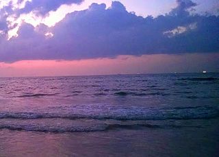
Panambur Beach is a beach on the shores of the Arabian Sea in the city of Mangalore in the Indian state of Karnataka.

Surathkal railway station is one of the main railway stations of Mangalore city along with Mangalore Central railway station and Mangalore Junction railway station and is located in north Mangaluru. Twenty-two trains stop here.KRCL operates RO-RO services from Suratkal to Verna, Kolad, and Karembeli. As per the Konkan railway map, Surathkal railway station is at a distance of 733.825 kilometers from the northern starting point of the Konkan railway line at Roha and 4.615 kilometers from Thokur which is the southern endpoint of Konkan railway jurisdiction. The Surathkal railway station is at distance of 26.285 Kilometre from Mangaluru Central(MAQ) railway station.

NITK Beach also known as Surathkal beach is on the Arabian Sea coast at Surathkal, 16 km (9.9 mi) north of the centre of Mangalore city, in the Dakshina Kannada district of Karnataka, India. It is a private beach that was later named after the nearby NITK.
Sasihithlu beach also known as Daibittil beach is located in Sasihithlu village, which is situated north of Mangalore city, in the state of Karnataka, in India. Sasihithlu Beach is situated approximately 6 km to the west of NH 66, and surrounded by the backwaters of the Pavanje and Shambhavi rivers. The two rivers meet at the beach. It is close to Mukka, one of the fastest developing localities of Mangalore. This beach hosted the Indian Open of Surfing in 2016 and 2017.

Permude is a village (panchayat) located in the Mangalore taluk, Dakshina Kannada district, in Karnataka state, India. The name, "Permude", derived from Perda Mudde, is a reference to the milk that was once locally produced in large quantities. Permude is located approximately 360 kilometers from the state capital, Bangalore. Nearby villages include Bajpe and Kinnigoli. According to 2011 census information, Permude's location code or village code is 617478. The village comprises an area of 742.69 hectares. Permude falls under the Mangalore Special Economic Zone (MSEZ).

