The Maluku Islands or the Moluccas are an archipelago in the east of Indonesia. Tectonically they are located on the Halmahera Plate within the Molucca Sea Collision Zone. Geographically they are located east of Sulawesi, west of New Guinea, and north and east of Timor. Lying within Wallacea, the Maluku Islands have been considered as a geographical and cultural intersection of Asia and Oceania.
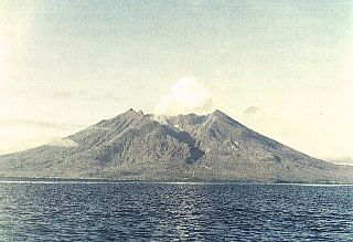
Makian, known to local people as Mount Kie Besi, is a volcanic island, one of the Maluku Islands within the province of North Maluku in Indonesia. It lies near the southern end of a chain of volcanic islands off the western coast of the province's major island, Halmahera, and lies between the islands of Moti and Tidore to the north and Kayoa and the Bacan Group to the south. The island, which forms two districts within South Halmahera Regency of North Maluku Province, covers an area of 84.36 sq.km, and had a population of 12,394 at the 2010 Census, which rose to 14,000 at the 2020 Census.

North Maluku is a province of Indonesia. It covers the northern part of the Maluku Islands, bordering the Pacific Ocean to the north, the Halmahera Sea to the east, the Molucca Sea to the west, and the Seram Sea to the south. The provincial capital is Sofifi on the largest island of Halmahera, while the largest city is the island city of Ternate. The population of North Maluku was 1,038,087 in the 2010 census, making it one of the least-populous provinces in Indonesia, but by the 2020 Census the population had risen to 1,282,937, and the official estimate as at mid 2022 was 1,319,338.

Seram is the largest and main island of Maluku province of Indonesia, despite Ambon Island's historical importance. It is located just north of the smaller Ambon Island and a few other adjacent islands, such as Saparua, Haruku, Nusa Laut and the Banda Islands.
Halmahera, formerly known as Jilolo, Gilolo, or Jailolo, is the largest island in the Maluku Islands. It is part of the North Maluku province of Indonesia, and Sofifi, the capital of the province, is located on the west coast of the island.
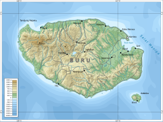
Buru is the third largest island within the Maluku Islands of Indonesia. It lies between the Banda Sea to the south and Seram Sea to the north, west of Ambon and Seram islands. The island belongs to Maluku province and includes the Buru and South Buru regencies. Their administrative centers, Namlea and Namrole, respectively, have ports and are the largest towns of the island, served by Namlea Airport and Namrole Airport.

Maluku is a province of Indonesia. It comprises the central and southern regions of the Maluku Islands. The main city and capital of Maluku province is Ambon on the small Ambon Island. The land area is 46,150.92 km2, and the total population of this province at the 2010 census was 1,533,506 people, rising to 1,848,923 at the 2020 census. The official estimate as at mid 2022 was 1,881,727. Maluku is located in Eastern Indonesia. It is directly adjacent to North Maluku, Southwest Papua, and West Papua in the north, Central Sulawesi, and Southeast Sulawesi in the west, Banda Sea, East Timor and East Nusa Tenggara in the south and Arafura Sea, Central Papua and South Papua in the east.

Ternate, also known as the City of Ternate, is a city in the Indonesian province of North Maluku and an island in the Maluku Islands. It was the de facto provincial capital of North Maluku before Sofifi on the nearby coast of Halmahera became the capital in 2010. It is off the west coast of Halmahera, and is composed of eight islands: Ternate, the biggest and main island of the city, and Moti, Hiri, Tifure, Mayau, Makka, Mano, and Gurida. In total, the city has a land area of 162.17 square kilometres and had a total population of 185,705 according to the 2010 census, and 205,001 according to the 2020 census, with a density of 1,264 people per square kilometre. It is the biggest and most densely populated city in the province, is the economic, cultural, and education center of North Maluku, and acts as a hub to neighbouring regions. It was the capital of the Sultanate of Ternate in the 15th and 16th centuries, and fought against the Sultanate of Tidore over control of the spice trade in the Moluccas before becoming a main interest to competing European powers.

Tidore is a city, island, and archipelago in the Maluku Islands of eastern Indonesia, west of the larger island of Halmahera. Part of North Maluku Province, the city includes the island of Tidore together with a large part of Halmahera Island to its east. In the pre-colonial era, the Sultanate of Tidore was a major regional political and economic power, and a fierce rival of nearby Ternate, just to the north.
The Obi Islands are a group of 42 islands in the Indonesian province of North Maluku, north of Buru and Ceram, and south of Halmahera. With a total area of 3,048.08 km2, they had a population of 41,455 at the 2010 Census and 50,760 at the 2020 Census. The official estimate as at mid 2021 was 51,510.

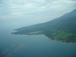
Tobelo is a town and a district on the eastern Indonesian island of Halmahera. It is the capital of the regency (kabupaten) of North Halmahera, part of the province of North Maluku. The town was formalised as the capital of North Halmahera in the district elections held in 2004. It had a population of 34,150 at the 2020 Census. A palm tree lined coastal road connects Tobelo to Galela. The town is predominantly Muslim with a large Christian minority and a Protestant Church has existed in Tobelo since at least 1924.

North Halmahera Regency is a regency of North Maluku Province, Indonesia. It was declared a Regency on 31 May 2003. The capital town of the regency lies at the port of Tobelo. The Regency, which has been considerably reduced by the separation of Tidore and of Morotai Island, now covers an area of 3,891.62 square kilometres (1,502.56 sq mi) and had a population of 161,847 people at the 2010 Census, 179,783 at the 2015 Intermediate Census. and 197,640 at the 2020 Census. The official estimate as at mid 2021 was 199,936. The principal settlements are Tobelo, Kao and Galela. The area is noted for its white beaches and coral reefs.
Ternate is a language of northern Maluku, eastern Indonesia. It is spoken by the Ternate people, who inhabit the island of Ternate and some other areas of the archipelago, including the western coast of Halmahera, Hiri, Obi, Kayoa, and the Bacan Islands. Historically, it served as the primary language of the Sultanate of Ternate, famous for its role in the spice trade. It has established itself as a lingua franca of the North Maluku province. A North Halmahera language, it is unlike most languages of Indonesia which belong to the Austronesian language family.
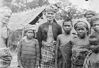
Buru people is an ethnic group mostly living on Indonesian island Buru, as well as on some other Maluku Islands. They also call themselves Gebfuka or Gebemliar, which literally means "people of the world" or "people of the land". Buru people are related to the eastern Indonesian anthropological group and from an ethnographic point of view are similar to other indigenous peoples of the island Buru. They speak the Buru language.
Lisela, also called Li Enyorot, is an Austronesian language; in 1989 it was spoken by about 11,900 Lisela people mostly living in the northern part of Indonesian island Buru. It is also preserved among the small Lisela community on the Ambon Island.

Ambelau or Ambalau is a volcanic island in the Banda Sea within Maluku Islands of Indonesia. The island forms an administrative district which is part of the South Buru Regency of Maluku province, Indonesia. It has a land area of 201.7 km2, and had a population of 6,846 at the 2010 Census. The administrative center is Wailua, a settlement located at the south of the island. About half of the island's population is composed of indigenous Ambelau people who speak the Ambelau language; the other half are mostly immigrants from the nearby Maluku Islands and Java.

The Maluku Islands sectarian conflict was a period of ethno-political conflict along religious lines, which spanned the Indonesian islands that compose the Maluku archipelago, with particularly serious disturbances in Ambon and Halmahera islands. The duration of the conflict is generally dated from the start of the Reformasi era in early 1999 to the signing of the Malino II Accord on 13 February 2002.
Suanggi is a malevolent spirit in the folklore of the Maluku Islands, Indonesia.
Sapalewa River, also Sapolewa, is a river of Seram Island, Maluku province, Indonesia, about 2400 km northeast of the capital Jakarta.
Tulehu is a village in Salahutu, Central Maluku Regency, Maluku, Indonesia.