
Canals are waterway channels, or artificial waterways, for water conveyance, or for servicing water transport vehicles. They carry free surface flow under atmospheric pressure, and can be thought of as artificial rivers.
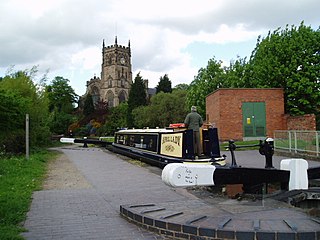
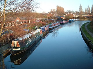
A narrowboat is a particular type of canal boat, built to fit the narrow locks of the United Kingdom. The UK's canal system provided a nationwide transport network during the Industrial Revolution, but with the advent of the railways, commercial canal traffic gradually diminished and the last regular long-distance transportation of goods disappeared in 1970. However, some commercial traffic continued. From the 1970s onward narrowboats were gradually converted into permanent residences or as holiday lettings. Today, approximately 6000 narrowboats are registered as permanent homes on Britain's waterway system and represent a growing alternative community living in semi permanent moorings or continuously cruising.
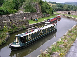
The Staffordshire and Worcestershire Canal is a navigable narrow canal in Staffordshire and Worcestershire in the English Midlands. It is 46 miles (74 km) long, linking the River Severn at Stourport in Worcestershire with the Trent and Mersey Canal at Haywood Junction by Great Haywood.
The Wyrley and Essington Canal, known locally as "the Curly Wyrley", is a canal in the English Midlands. As built it ran from Wolverhampton to Huddlesford Junction near Lichfield, with a number of branches: some parts are currently derelict. Pending planned restoration to Huddlesford, the navigable mainline now terminates at Ogley Junction near Brownhills. In 2008 it was designated a Local Nature Reserve.

The canal network of the United Kingdom played a vital role in the Industrial Revolution. The canals permitted the creation of wealth, by industry, that led to the British Empire in the Victorian Era. The UK was the first country to develop a nationwide canal network, which expanded to nearly 4,000 miles in length. The canals allowed raw materials to be transported to a place of manufacture, and finished goods to be transported to consumers, more quickly and cheaply than via a land based route.

The Worcester and Birmingham Canal is a canal linking Birmingham and Worcester in England. It starts in Worcester, as an 'offshoot' of the River Severn and ends in Gas Street Basin in Birmingham. It is 29 miles (47 km) long. There are 58 locks in total on the canal, including the 30 Tardebigge Locks, one of the largest lock flights in Europe. The canal climbs 428 feet (130 m) from Worcester to Birmingham.

The canals of the United Kingdom are a major part of the network of inland waterways in the United Kingdom. They have a varied history, from use for irrigation and transport, through becoming the focus of the Industrial Revolution, to today's role of recreational boating. Despite a period of abandonment, today the canal system in the United Kingdom is again increasing in use, with abandoned and derelict canals being reopened, and the construction of some new routes. Canals in England and Wales are maintained by navigation authorities. The biggest navigation authorities are the Canal & River Trust and the Environment Agency, but other canals are managed by companies, local authorities or charitable trusts.

Dudley Tunnel is a canal tunnel on the Dudley Canal Line No 1, England. At about 3,172 yards (2,900.5 m) long, it is now the second longest canal tunnel on the UK canal network today.. However, since the Dudley Tunnel is not continuous this status is sometimes questioned:.

The Stourbridge Canal is a canal in the West Midlands of England. It links the Staffordshire and Worcestershire Canal with the Dudley Canal, and hence, via the Birmingham Canal Navigations, to Birmingham and the Black Country.

The Dudley Canal is a canal passing through Dudley in the West Midlands of England. The canal is part of the English and Welsh connected network of navigable inland waterways, and in particular forms part of the popular Stourport Ring narrowboat cruising route.

The River Wey Navigation and Godalming Navigation together provide a 20-mile (32 km) continuous navigable route from the River Thames near Weybridge via Guildford to Godalming. Both waterways are in Surrey and are owned by the National Trust. The River Wey Navigation connects to the Basingstoke Canal at West Byfleet, and the Godalming Navigation to the Wey and Arun Canal near Shalford. The Navigations consist of both man-made canal cuts and adapted parts of the River Wey.
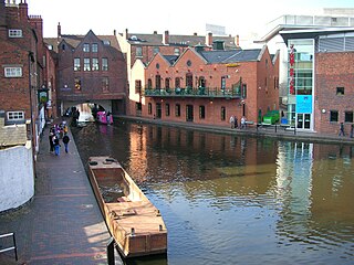
Gas Street Basin is a canal basin in the centre of Birmingham, England, where the Worcester and Birmingham Canal meets the BCN Main Line. It is located on Gas Street, off Broad Street, and between the Mailbox and Brindleyplace canal-side developments.
The BCN Main Line, or Birmingham Canal Navigations Main Line describes the evolving route of the Birmingham Canal between Birmingham and Wolverhampton in England.

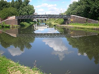
The Birmingham Canal Navigations (BCN), a network of narrow canals in the industrial midlands of England, is built on various water levels. The three longest are the Wolverhampton, Birmingham, and Walsall levels. Locks allow boats to move from one level to another.

The Titford Canal is a narrow (7 foot) canal, a short branch of the Birmingham Canal Navigations (BCN) in Oldbury, West Midlands, England.

The Tipton Green Branch and Toll End Branch were narrow canals comprising part of the Birmingham Canal Navigations near Tipton, West Midlands, England. These canals no longer exist.
Wednesbury Old Canal is part of the Birmingham Canal Navigations (BCN) in West Midlands (county), England. It opened in 1769, and although parts of it were abandoned in 1955 and 1960, the section between Pudding Green Junction and Ryder's Green Junction is navigable, as it provides a link to the Walsall Canal. A short stub beyond Ryder's Green Junction is connected to the network but difficult to navigate.

The Wednesbury Oak Loop, sometimes known as the Bradley Arm, is a canal in the West Midlands, England. It is part of the Birmingham Canal Navigations (BCN), and was originally part of James Brindley's main line, but became a loop when Thomas Telford's improvements of the 1830s bypassed it by the construction of the Coseley Tunnel. The south-eastern end of the loop was closed and in parts built over, following the designation of the entire loop as "abandoned" in 1954, including the section which was filled in at the beginning of the 1960s to make way for the Glebefields Estate in Tipton.

The Bradley Branch or Bradley Locks Branch was a short canal of the Birmingham Canal Navigations in the West Midlands, England. Completed in 1849, it included nine locks, and had a number of basins which enabled it to service local collieries and industrial sites. The locks were unusual, as they had a single gate at both ends, rather than double gates at the bottom end. The route closed in the 1950s, and the top seven locks were covered over and landscaped.
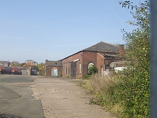
The Boat Gauging House is a building in Tipton, West Midlands, England. It is situated by the Main Line of the Birmingham Canal Navigations, and was used for calibrating new canal boats in order later to ascertain the weight of cargo carried. It is a Grade II listed building.


