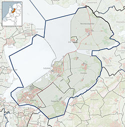
Flevoland is the twelfth and newest province of the Netherlands, established in 1986, when the southern and eastern Flevopolders, together with the Noordoostpolder, were merged into one provincial entity. It is in the centre of the country in the former Zuiderzee, which was turned into the freshwater IJsselmeer by the closure of the Afsluitdijk in 1932. Almost all of the land belonging to Flevoland was reclaimed in the 1950s and 1960s while splitting the Markermeer and Bordering lakes from the IJsselmeer. As to dry land, it is the smallest province of the Netherlands at 1,412 km2 (545 sq mi), but not gross land as that includes much of the waters of the fresh water lakes (meres) mentioned.
Lelystad is a municipality and a city in the centre of the Netherlands, and it is the capital of the province of Flevoland. The city, built on reclaimed land, was founded in 1967 and was named after Cornelis Lely, who engineered the Afsluitdijk, making the reclamation possible. Lelystad is approximately 3 metres below sea level.

The IJsselmeer, also known as Lake IJssel in English, is a closed-off inland bay in the central Netherlands bordering the provinces of Flevoland, North Holland and Friesland. It covers an area of 1,100 km2 (420 sq mi) with an average depth of 4.5 m (15 ft). The river IJssel flows into the IJsselmeer.

The Zuiderzee or Zuider Zee was a shallow bay of the North Sea in the northwest of the Netherlands, extending about 100 km inland and at most 50 km wide, with an overall depth of about 4 to 5 metres (13–16 feet) and a coastline of about 300 km. It covered 5,000 km2 (1,900 sq mi). Its name is Dutch for "southern sea", indicating that the name originates in Friesland, to the north of the Zuiderzee.
The Zuiderzee Works is a human-made system of dams and dikes, land reclamation and water drainage work, in total the largest hydraulic engineering project undertaken by the Netherlands during the twentieth century. The project involved the damming of the Zuiderzee, a large, shallow inlet of the North Sea, and the reclamation of land in the newly enclosed water using polders. Its main purposes are to improve flood protection and create additional land for agriculture.
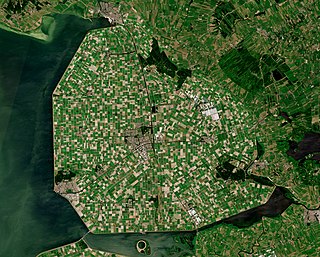
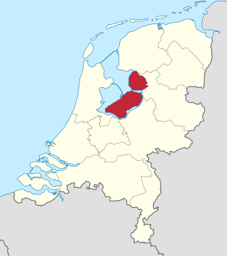
Noordoostpolder is a polder and municipality in the Flevoland province in the central Netherlands. Formerly, it was also called Urker Land. Emmeloord is the administrative center, located in the heart of the Noordoostpolder.

Urk is a municipality and a town in the Flevoland province in the central Netherlands.

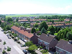
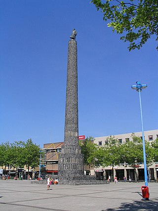
Emmeloord is the administrative centre of the municipality of Noordoostpolder, Flevoland, Netherlands. In 2019, it had a population of 26,055.

Kraggenburg is a settlement in the Noordoostpolder area of the Netherlands.. The village is situated south east of the regional town Emmeloord.

Schokland is a former island in the Dutch Zuiderzee, in the municipality of Noordoostpolder. Schokland was an elongated strip of peat land which ceased to be an island when the Noordoostpolder was reclaimed from the sea in 1942. It is now just a slightly elevated part of the polder, with a still partly intact retaining wall of the waterfront of Middelbuurt. On 1 April 2014, it had 8 inhabitants, but according to Statistics Netherlands there are five people living on the former island.

Ens is a village in the Dutch province of Flevoland. It is a part of the municipality of Noordoostpolder, and lies about 10 km southeast of Emmeloord.

Creil is one of the ten so-called green villages (Dutch: groendorpen) in the Dutch province of Flevoland. It is a part of the municipality of Noordoostpolder, and lies about 6 km northwest of Emmeloord.

Bant is one of the so-called green villages (Dutch: groendorpen) in the Dutch province of Flevoland. It is a part of the municipality of Noordoostpolder, and lies about 7 km north of Emmeloord.

Espel is one of the so-called green villages (Dutch: groendorpen) in the Dutch province of Flevoland. It lies in the municipality of Noordoostpolder next to a crossroads where provincial road N712 from Urk to Lemmer intersects with road N714 to Emmeloord, roughly 6 km to the east.
Marknesse is a village in the Dutch province of Flevoland. It is a part of the municipality of Noordoostpolder, and lies about 7.5 kilometres (4.7 mi) east of Emmeloord.

Nagele is a village in the Dutch province of Flevoland. It is a part of the municipality of Noordoostpolder, and lies about 10 km south of Emmeloord.

Zwolle is the main railway station of Zwolle in Overijssel, Netherlands. The station opened on 6 June 1864 and is on the Utrecht–Kampen railway, also known as the Centraalspoorweg, the Zwolle–Almelo railway, the Arnhem–Leeuwarden railway, the Zwolle–Stadskanaal railway and the Lelystad–Zwolle railway, also known as the Hanzelijn.

Rutten is a village in the central Netherlands. It is located in Noordoostpolder, Flevoland, about 8 km northwest of Emmeloord. It was founded in 1952.

The pilot Polder Andijk, or Test Polder Andijk, Proefpolder Andijk in Dutch, is a polder established in 1926 - 1927 in the Zuiderzee near the village of Andijk. The aim of this prototype is to study the embankments and agriculture for future polders in the Zuiderzee Works. In 1929, the pilot polder was inaugurated by Queen Wilhelmina of the Netherlands.