A toothbrush is an oral hygiene tool used to clean the teeth, gums, and tongue. It consists of a head of tightly clustered bristles, atop of which toothpaste can be applied, mounted on a handle which facilitates the cleaning of hard-to-reach areas of the mouth. They should be used in conjunction with something to clean between the teeth where the bristles of the toothbrush cannot reach - for example floss, tape or interdental brushes.

Rutherglenpronunciation (help·info) is a small town in north-eastern Victoria, Australia, near the Murray River border with New South Wales. The town was named after the Scottish town of Rutherglen which lies just outside Glasgow. At the 2016 census, Rutherglen had a population of 2,109.

Moturoa / Rabbit Island is a small island that lies across the southernmost part of Tasman Bay / Te Tai-o-Aorere, on the northern coast of New Zealand's South Island. The long narrow island runs east–west for 8 kilometres (5 mi), and covers 15 km2 (5.8 sq mi).

The Firth of Thames is a large bay located in the north of the North Island of New Zealand. It is the firth of the rivers Waihou and Piako, the former of which was formerly named the Thames River, and the town of Thames lies on its southeastern coast.

The Bombay Hills are a range of hills to the south of Auckland, New Zealand. Though only a small and seemingly insignificant range of hills, they lie at the southern boundary of the Auckland region, and serve as a divide between Auckland and the Waikato region. There is a 19th-century settlement, Bombay, on the old main road south of Auckland, the Great South Road.
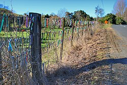
Graeme William Cairns is a New Zealand musician, artist, and political candidate. Originally from Scotland, he is perhaps best known for his role as "Laird McGillicuddy", chief of the Clan McGillicuddy, and as the only-ever leader of the Clan's satirical McGillicuddy Serious political party. In the 1996 election, he was, at 65, the lowest-ranked candidate on their party list. At the next election in 1999, when he stood in the Port Waikato electorate, he was in first rank on the party list. In 2006, he built a toothbrush fence as an absurdist art project.
Okoroire is a small settlement in the South Waikato District and Waikato region of New Zealand's North Island, centered around the Okoroire Hot Springs. The place name means 'place of the koroire / toroire, an extinct species of ring-necked duck.
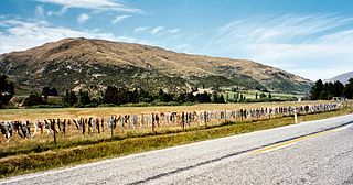
The Cardrona Bra Fence is a controversial tourist attraction in Central Otago, in New Zealand. At some point between 1998 and 1999, passers-by began to attach bras to a rural fence. The fence gradually became a well known site as the number of bras grew to hundreds. The fence is located on a public road reserve, adjacent to farm property in the Cardrona Valley area southwest of Wanaka, near to Cardrona.

The Goldfields Railway is a heritage railway that operates between Waihi and Waikino in the Bay of Plenty region of New Zealand's North Island. It operates over a section of track that was part of the East Coast Main Trunk Railway until the Kaimai Tunnel deviation made it redundant in 1978. The Goldfields Railway was formed in 1980 as the Goldfields Steam Train Society to retain a portion of the old mainline and switched to its current name in the mid-nineties.

"Bret Gives Up the Dream" is the second episode of the HBO comedy series Flight of the Conchords. The episode first aired in the United States on Sunday, June 24, 2007.
The Waikato Institute of Technology, also known as Wintec, is an institute of technology based in New Zealand's Waikato region. Wintec offers over 130 degrees, diplomas and certificates. Wintec specialises in applied tertiary training for nurses, social workers, midwives, graphic designers, performing artists, engineers, trades people, early childhood teachers, horticulturists, arborists and sport scientists. Programmes range from Level 1 to Level 9.

The Martha Mine is a gold mine in the New Zealand town of Waihi. Since July 2015 it has been owned by Australian-based OceanaGold.

Wairere Falls, the highest waterfall in New Zealand's North Island, plunges 153 metres (500 feet) in two steps over the Kaimai escarpment.

Eric Gordon Murray is a retired New Zealand rower and gold medalist at the 2012 London Olympic Games, as well as at the 2016 Rio de Janeiro Olympic Games. He won six consecutive World Rowing Championship gold medals in the coxless pair plus two other gold medals in the coxless four and coxed pair. In 2012 an 2014 he set two world best times in the coxless pair and coxed pair respectively, which as of 2021 still stand as the world's best in those boat classes.

The Hamilton Town Belt, also known as the Green Belt, is a series of public parks in Hamilton, New Zealand that surround the original 1877 city boundaries. Many of the cities notable venues and attractions are located on the belt, including Hamilton Gardens, Waikato Stadium, Seddon Park, Hamilton Girls' High School, Founders Theatre and the Hamilton Lake Domain.
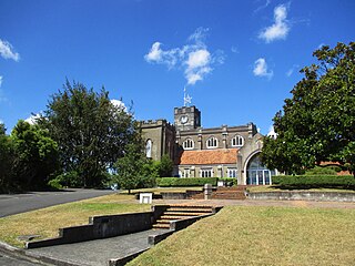
St Peter's Cathedral is the Anglican cathedral in Hamilton, located in the Waikato region of the North Island of New Zealand. It is located on a small hill, known as Cathedral Hill, in the southern central part of the city off Victoria Street.
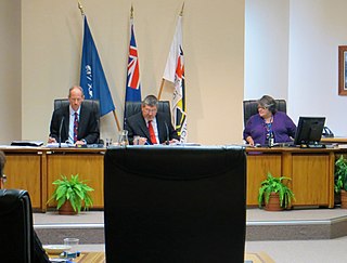
Waikato District Council is the territorial authority for the Waikato District of New Zealand.
The Office of the Waikato District Hospital and Charitable Aid Board (Former) is a historic building at 17 Hood Street, in the CBD of Hamilton and was in 2008 listed as Category 2 by Heritage New Zealand.

The Waikato District Health Board was a district health board that provided healthcare to the Waikato region of New Zealand.
Maratoto is a valley and rural community in the Hauraki District and Waikato region of New Zealand's North Island, north of Paeroa.