Stari Jankovci is a village and a municipality in Vukovar-Syrmia County, Croatia

Borovo, also known as Borovo Selo, is a village and a municipality in Vukovar-Syrmia County in eastern part of Croatia. Situated on the banks of the Danube river, it shares its border with Serbia and the municipality of Bač on the opposite side. The historical development of Borovo is intricately linked with the Danube, which has played a pivotal role in its development as a notable industrial hub in the region.

Konavle is a municipality and a small Dalmatian subregion located southeast of Dubrovnik, Croatia.

Pećinci is a village and municipality located in the Srem District of the autonomous province of Vojvodina, Serbia. The village has a population of 2,581 (2011), while Pećinci municipality has 19,720 inhabitants.
Erdut is a village and a municipality in eastern Croatia some 37 km east of the major city of Osijek. Lying on the border with neighbouring Serbia, it was the site of the signing of the 1995 Erdut Agreement, which initiated the UNTAES transitional administration over the Eastern Slavonia, Baranja and Western Syrmia.

Benkovac is a town and municipality in the Zadar County, Croatia.

Markušica is a village and a municipality in Vukovar-Syrmia County in eastern Croatia. Markušica is located south of the river Vuka and northwest of the town of Vinkovci. The landscape of the Markušica Municipality is marked by the Pannonian Basin plains and agricultural fields of wheat, maize, common sunflower and sugar beet.

Negoslavci is a village and a municipality in Vukovar-Syrmia County in eastern Croatia. It is located south of the town of Vukovar, seat of the county. Landscape of the Negoslavci Municipality is marked by the Pannonian Basin plains and agricultural fields of maize, wheat, common sunflower and sugar beet.

Trpinja is a village and an eponymous municipality in the Vukovar-Syrmia County in eastern Croatia. The village is located on the D55 road between Osijek and Vukovar. Landscape of the Trpinja Municipality is marked by the Pannonian Basin plains and agricultural fields of maize, wheat, common sunflower and sugar beet.

Šodolovci is a village and a municipality in Osijek-Baranja County in eastern Croatia. In the seven villages of the Šodolovci Municipality, there were 1,653 inhabitants at the time of the 2011 Census.
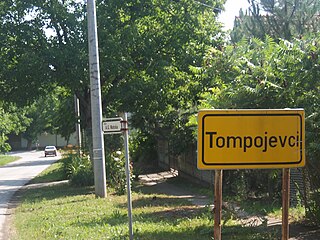
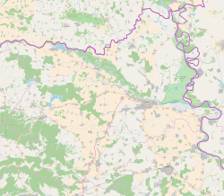
Tompojevci is a village and municipality in the Vukovar-Syrmia County in Croatia.

Čepin is a village and a municipality in Osijek-Baranja County, Croatia. It is located in northeast Slavonia, 10 kilometers southwest of Osijek.

Goričan is a municipality in Međimurje County, Croatia.

Pogány is a village in Baranya county, Hungary.
Andrijaševci is a village and a municipality in Vukovar-Syrmia County in eastern Croatia. Despite its name, the seat of the municipality is in the village of Rokovci.

Srijemske Laze is a village in Stari Jankovci municipality of Vukovar-Syrmia County in eastern Croatia. The village is physically connected with the village of Slakovci. According to 2011 census there is 566 residents in the village. The largest ethnic group in the village are Serbs of Croatia. The village is connected with the rest of the country by the D46 state road connecting it with the town of Vinkovci and continuing into Serbia as the State Road 120 to the nearest town of Šid. Surrounding landscape of the village is marked by the Pannonian Basin plains and agricultural fields of corn, wheat, common sunflower and sugar beet.

Vinkovački Banovci is a village in Croatia in the region of Syrmia. The village is a part of the Nijemci Municipality.

Ćelije sometimes also referred to as Ćelija, is a village in eastern Croatia located west of Trpinja and south of the Osijek Airport. The population is 121.
The Srb uprising was a rebellion against the Independent State of Croatia that began on 27 July 1941 in Srb, a village in the region of Lika. The uprising was started by the local population as a response to persecutions of Serbs by the Ustaše and was led by Chetniks and Yugoslav Partisans. It soon spread across Lika and Bosanska Krajina. During the uprising numerous war crimes were committed against local Croat and Muslim population, especially in the area of Kulen Vakuf. As NDH forces lacked the strength to suppress the uprising, the Italian Army, which was not a target of the rebels, expanded its zone of influence to Lika and parts of Bosanska Krajina.